New Zealand Geyser Gazing
When Suzanne and I started planning for our New Zealand trip, we didn't know what to expect when it came to thermal activity there. From the few other gazers who'd been there, we did know that the activity was a lot less, and that you had to pay for admission. This posting is a generally organized attempt to help others better plan for their trip, and to have some idea what to expect when you get there.
In another posting, I will list a number of links to sites that were either useful, or provided reference material. I've also uploaded to my server several old reports that turned out to be useful, especially their maps, which on the whole are still relevant.
Over the years, I've accumulated a few items on thermal activity in New Zealand. Years ago I managed to get copies of several books through inter-library loans and make photo copies of most of their pages and maps. Later I managed, through eBay and ABE and Alibris to get the actual books, with their sharper photos and maps. But a search of Amazon, for example, didn't turn up anything new that seemed worth buying.
Several GOSA Transactions articles from Vol.7 were useful, as was T.Scott Bryan's short report in Vol.5. We also got some first hand info from Tara Cross about what she'd seen when visiting about 15 years ago. Even the little bits from Mara and Dimitri from their Orakeikorako visit a week earlier helped.
Online, I could find little to nothing about current activity. Current meaning in the last few years. There were some sites that included mentions of thermal areas I didn't know about, and even some mention of geysers and boiling springs.
By the time we ready to leave, I'd determined that there were six places with geysers, and another couple of areas worth visiting in the time we had allocated. One of the places, Ketetahi, an inholding in Mt.Tongariro National Park, for several years now has been off-limits mostly due to the excesses of Nature Lovers seeking hot water, and their abuses of the area. There were reports of at least one or two geysers there. As it turned out, we would've been hard pressed to visit there as part of the Crossing hike anyhow.
Of the other areas, the only reference to a free geyser I could find was that at Tokaanu, which contained at least one geyser. The problem here is that it is over an hour and a half drive from Rotorua, including driving through or around Taupo and vicinity. Fortunately, we were going to be staying nearby for our hike at Mt.Tongariro, and so would be able to stop by.
The two additional areas are free that we could visit. These were Kirirau Park, in downtown Rotorua, and Te Kopia, northeast of Orakeikorako. The first sounded so bizarre that I had to experience it, and the latter was a small area of mudpots (including a "mud geyser" in years past) that was along a route we were going to take anyhow.
As it turned out, we visited one other free area, Te Aroha, because we were driving right through the town and had the time to check out the soda water geyser there. I hadn't planned on visiting it originally as I didn't think we were going there, and erupting wells aren't that high on my list of things to see.
Following are detailed notes on all the areas, including places we didn't visit. On a future visit, I'd like to visit those we missed, at least for completeness, and maybe even to discover an undocumented geyser or two.
For the paid areas, the first disappointment was that all of them were only open about 8 to 10 hours a day. For someone used to access to Yellowstone geysers at any time (except when there are bears about, or a gov't shutdown performance in progress) that was annoying. As it turned out, that was usually sufficient time, and even forced us to wrap things up in a timely manner and rest up for the next day.
In general, New Zealand was a great place for guru geyser gazing. We had almost no information to go on, and only a few hours to make observations, so had to make assumptions and guesses and then live with them. But in three different cases, we managed to use the little information we did have, or what we observed, to see activity of Kereru Geyser, Sapphire Geyser and Waiotapu Geyser.
On the other hand, there's no interest in recording and reporting on day to day changes in activity, or at least in publicizing it. Perhaps it's an attempt to pretend ignorance of activity is somehow "closer to nature" in areas that have had "cultural uses" for hundreds of years. Or just that it's not worth the effort when the vast majority of visitors to the areas don't know or care. (Think of the streams of people heading for their cars as Old Faithful is still erupting...)
Unanswered questions:
Are FRS radios legal?
If so, next time I'd bring some, as there are several places where it's have been nice to split up, especially at Orakeikorako and Whakarewarewa.
It is possible to get multi-day passes?
Again, a return visit to Orakeikorako would probably be worth the effort, as the area seems to vary considerably. Based on our one day, Pohutu could use an extended study, too.
Is there a way to see the Rotomohana features other than the boat tour?
I'm sure it would be expensive, but it would be really interesting to spend a day on a rented boat watching those lakeshore features.
Is it possible to visit Ketetahi?
One would have to get special permission. If so, it's also steep slog up from the trailhead, and the parking there is limited to four hours.
Are there webcams?
Don't seem to be. Would think Pohutu would be a prime candidate, and easy to do. One from the Orakeikorako visitor center looking across the lake would be interesting, too.
(Doesn't seem to be one on Geysir & Strokkr anymore, either.)
Places Visited:
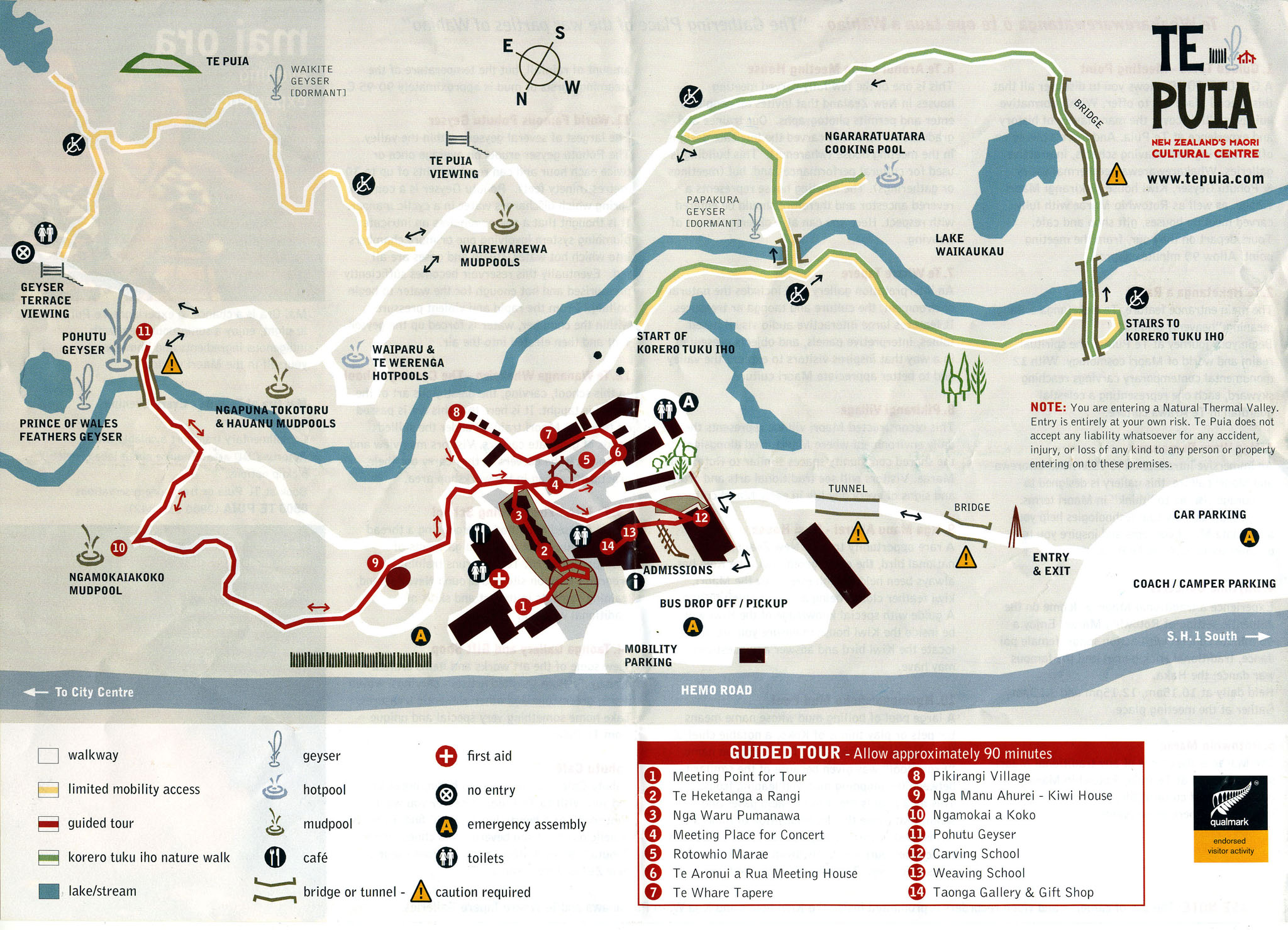
- Location: Whakarewarewa (Te Puia)
- Type: Paid
- Observed Geysers:
Pohutu Geyser
Te Tohu Geyser (Prince of Wales Feathers Geyser)
Kereru Geyser
Small sput to north of Te Tohu - Other Geysers:
Papakura
Waikorohihi
Mahanga - General:
Few places to sit, but lots of railings (on which they don't want you to sit.)
Side spur below the bridge is a good place to watch Kereru. There's also a good viewpoint directly from the paved path from the entrance to the bridge, coming down from Ngamokaiakoko mud pots. We weren't aware of this until late in the afternoon, as we approached Pohutu down the more direct gravel path because Te Teho was in eruption as we arrived. This location also allows a view directly into Kereru's vent.
Across the stream from Pohutu and Kereru was a flat area with several small sputters and frying pans. We never noticed any variation in their activity while we were there.
We stayed in a Holiday Park that was in easy walking distance. Our accommodation was similar to an Old Faithful Budget cabin, but with kitchen facilities. We had refrigerator, sink, microwave, hot plate and some cooking utensils. Toilet and shower facilities were in a nearby building, as well as a common kitchen area. There were also hot soaking pools, filled by one of the bores not closed in the 1980s.
To get to Te Puia, we had to use the pedestrian underpasses under a traffic circle. There were three, with two necessary to get through the intersection. The third led to the northeast side of the roads, from where we could see some of the thermal features in the golf course.
The area opens at 08:00. We were the first ones in at 07:59, and almost immediately saw Te Tohu in eruption.
This is an area which is part of the Tourism-Industrial Complex. Roturua is full of all sorts of "adventure" activities and "experiences", and Te Puia is advertised as one of them. It's the one thermal area where we got to experience the Asian Invasion™, although we didn't see any guides carrying flags. The area around Pohutu would go from overcrowded to nearly empty, independent of the activity of the geyser. It all depended on the timing of the cultural exhibits and the arrival of bus tours.
There is an overlook where Pohutu can be seen for free, at a distance. Sort of like Observation Point for Old Faithful. Go to the Redwood Forest "iSite" information center and hike the yellow trail. (Trails are color coded, and there are lots of them in that area.) That leads to an overlook with a clear view of Pohutu. One could probably see Kereru's steam cloud from there, too, although it would be directly behind Pohutu, and obscured if Pohutu is in eruption. This overlook can also be approached by going to the bicycle parking lot off of SH-5 and hiking the yellow trail in reverse. Be aware that there are branches that aren't signed because they assume the route is obvious to someone walking in the proper order, so expect a little backtracking. (Or at least that's what happened to us.) The noise from the cicadas was deafeningly loud at times. The brim of a hat actually cuts down on that noise even without covering the ears. Also, that bike parking lot closes around dusk, with a locked gate, and there's a fee to unlock it to get out.
We also saw Pohutu in eruption while driving on Fenton Street. The exact locations are an exercise for others to determine. We were too busy keeping left and navigating the roundabouts.
- Kereru:
We'd heard from Dimitri Stoumbos and Mara Reed that Kereru gave very little warning, and that it had minor play after the eruption. That was the sum total of what we had to work with.
It appears Kereru is completely quiet before the initial eruption. We waited for several hours, with a few absences to see the rest of the area, and never saw anything of interest. We left maybe ten minutes before the first eruption to get a different view of Pohutu, which was about to start, when it suddenly took off.
After this first eruption, where were splashes, and small minors, until the second major eruption. After the second eruption, there were a number of larger, more frequent minors. So the activity was definitely different in the two intervals. We weren't around much after the third eruption, but it seemed like the minors were smaller. - Pohutu:
The signs and guide brochures say that Pohutu erupts once or twice an hour. We didn't see that. Instead all but the last intervals we saw were about 1h30m to 1h45m, with durations around 50 minutes. Then there was an eruption that lasted almost twice as long.The last interval was longer, and then the duration of that eruption was shorter. So there's some variation there that could use some investigation.
Observed activity:
Time Duration Interval Quiet 08:03ns >52m46s 57m 09:48 47m58s 1h45m 44m 11:19 47m17s 1h31m 50m 12:56 49m02s 1h37m 52m 14:37 1h34m03s 1h41m 1h02m 17:13 ~20m 2h36m - Small feature near Te Tohu:
A couple of meters to the left of Te Tohu, as seen from our usual vantage point for Kereru, was a small sput. About 10cm high at most, it was occasionally active during an eruption of Pohutu. I did capture a few seconds of its activity in one of the videos of Pohutu.
- Location: Kuirau Park
- Type: Free
- Observed Geysers:
None - Other Geysers
None - General:
Lots of thermal features, every one surrounded by a well-built fence. Park on Kuirau Street, which goes through the park.
It seems like the activity is hotter at the north end of the park. At the southern end there were just scummy, watery mudpots. There was one feature, near the thermal sculpture exhibit which was boiling and splashing. The area around it seemed like it was wet in the past, but was dried out when we were there. In general, a lot of features seemed to be not at their highest water level.
- Location: Waiotapu
- Type: Paid
- Observed Geysers:
Waiotapu Geyser
Lady Knox "Geyser" - Other Geysers:
Several small features at head of Primrose Terrace near Champaign Pool - General:
You've got to see Lady Knox at least once, but I'm not sure I'd go again. There are a lot of disadvantages to seeing it.
The performance timing is wrong. It comes two hours after the main thermal area opens, and is far enough from there that you have to drive there and back. We got a great parking spot in the morning, then when we returned were shunted off to overflow parking. All that wasted a lot of time better spent seeing real thermal activity.
Also, it causes a huge crowd to flow through the thermal area after the performance. We missed a lot of that because we actually stayed until about 11:00, but even then we could notice that it wasn't as crowded as the afternoon progressed. (Although, we did spend several hours at one location.)
The first trail loop goes through and around a large number of huge collapse holes which have small pools at their bottoms. They are so deep that you need to consider the sun angle to see down into them, so
- Feature: Champaign Pool and Primrose Terrace
On the east side there are a number of small steaming features warm enough to keep the bacterial mats from encroaching. A couple of these had raised rims as if they were formed from splashing, but the times we passed by there wasn't any indication of activity.
- Feature: Waiotapu Geyser
In an older Youtube video, this feature is shown with a small fence around it, with its name on a sign. We originally passed right by this feature, because they've changed that. I did find a few frames of it on a video I took during that walk.
Once realized that we hadn't seen it, used the map from Lloyd's Waiotapu paper published in 1959 it figure out where we needed to return. It's #70, and fits the description he gave.
We arrived to find it full, but not really overflowing. It bubbled occasionally. Over the next hour, the bubbling increased, as did the trickle of water.
Eventually the bubbling was continuous, and we got a surge of activity. After that, the water level dropped, only to quickly rise back up. This time the bubbling turned into splashes, enough that I'd consider it to be a minor eruption.
Following the minor, the water dropped again, then rose back up. This time the splashes got stronger, and turned into a full eruption. The water level stayed high at first, with bursting out of the pool, but quickly dropped so that most of the eruptive activity was coming from an drained vent. At the end the splashed turned more into spray, and the eruption ended with heavy steaming coming from the vent.
To the right of the main pool is a small vent, about 4cm across. That was full of water and bubbling before the eruption, but drained and was empty afterwards.
What little information I've been able to find says that the interval is "hours" to 12 hours. That seems reasonable, as the brief glimpse in my first video shows the vent full just like we found it later. We also don't know how long it takes for the vent to fill to that level. So there's lots more to discover about this feature.
- Feature: Lady Knox "Geyser"
This is actually a pretty impressive feature. Having soaped geysers in the past, it was amusing to compare it to our experiences at Steamboat Springs, Nev. back in the 1980s.
The amount of soap used wasn't as much as we used, and it was powdered, while we found liquid worked better. But the progression was similar, with a period of "over-foaming" before the eruption started. Like #42w, after the initial discharge, the water wasn't foamy any more.
The crowd ran away within a minute of the start, as that's when the water column dropped down to less than a meter. But a bit later, a less foamy column achieved full height, maybe even higher than before. This would drop and rise over the next half hour, but was still higher than that as we left.
Definitely get there about a half hour early, take an umbrella and sit up front. Check the wind direction.
- Feature: Devil's Cave
The last numbered item on the tour map, one of the large craters at the north end near the entrance, the color was a remarkably bright yellowish-green. It was even brighter in person than on video, almost phosphorescent.
- Location: Waimangu
- Type: Paid
- Observed Geysers:
"Pink Terrace" Geyser
Iodine Spring
Bird's Nest Terrace, a continuous spouter. - Other Geysers:
A number of spouters at Fumarole Bay, and the guide said there were four geysers there when the lake level is low.
Many sputs and spouters along the Hot Water Creek could be geysers. - General:
Keep in mind that this area did not exist prior to the 1886 June 10 eruption of Mt. Tarawera. All of the green stuff, the formations and the springs are all new.
Don't bother with the side trip to Mt. Haszard. It's steep and there's never really any distant views due to all the thick green stuff. Which is too bad, because every so often you get an idea that there could be some impressive views of the craters and the lake in the distance.
If you take the boat tour, schedule one at 11:30 or later. That will give you more time to walk the route. Then pick up the bus at stop #2 (Warbrick Terrace) and ride it to the dock, as there's really nothing thermal to see between there and the lake. Why walk when you can ride?
Visitor center sells books, prints and posters about thermal features.
- Feature: Inferno Crater
Over a period of weeks, the water level in this feature fluctuates over a range of about five meters. We saw it when it was only down about a meter, and there was no evidence of overflow through the runoff. That probably means it was overflowing a few days later, based on the information I've been able to find about the feature.
- Feature: Waimangu Geyser Crater
We passed through this area and didn't even realize we were in Waimangu Geyser, or at least at the site where it used to be. It's an odd, empty area bordered by Hot Water Creek and many sputs on the north side.
- Feature: Iodine Spring
This feature is visible from the walking trail, but the bus route passes right next to it. When we returned from the boat cruise, we obeyed the sign requesting pedestrians to use the trail. That was a mistake. On one of my videos you can see at least one plume of water going to about two meters several times.
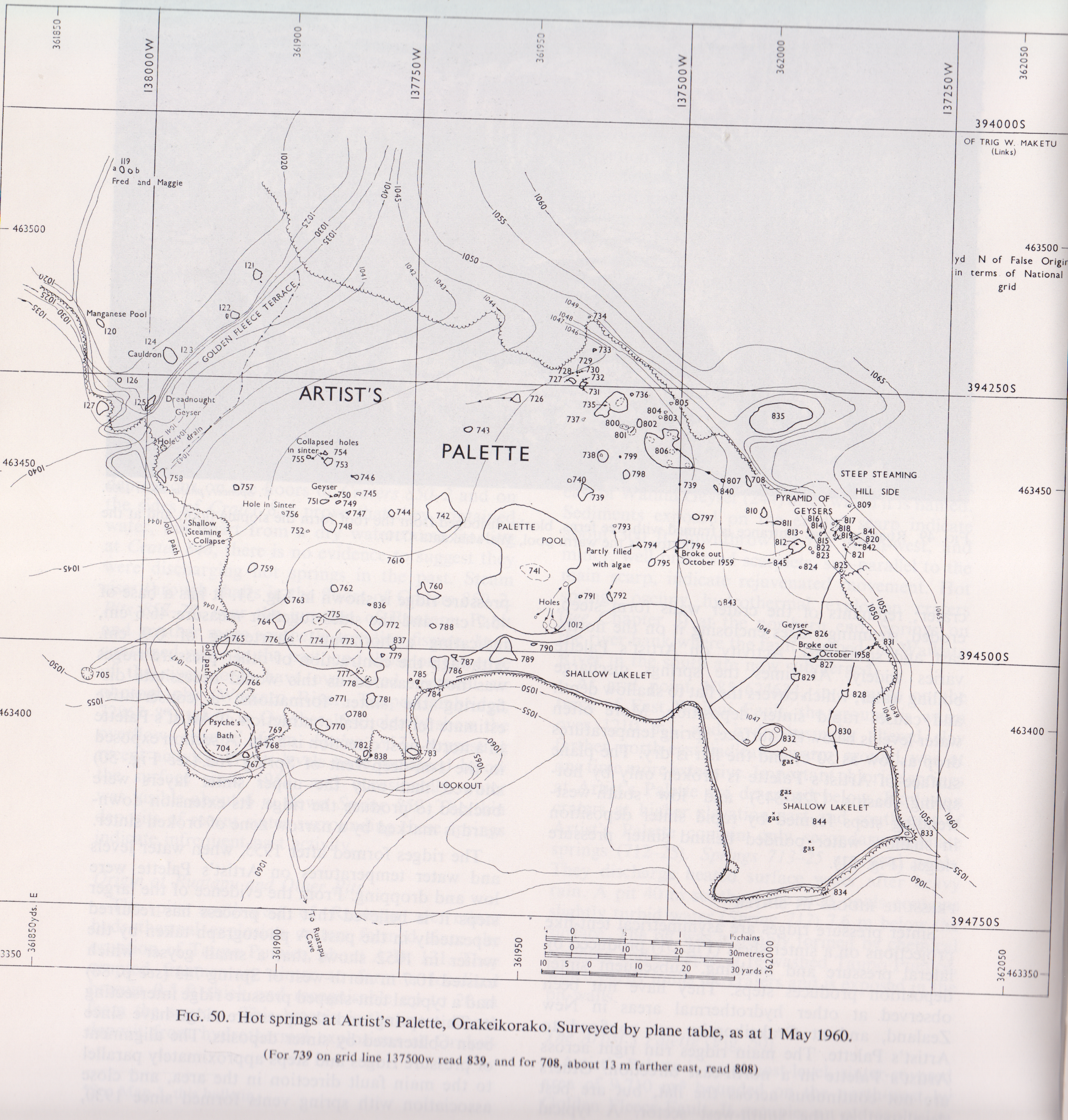
- Location: Orakeikorako
- Type: Paid
- Observed Geysers:
Sapphire Geyser
Cascade Geyser
Soda Fountain Geyser
New Feature (#120nw)
Artist's Palette:-
#742 - Square Spring
#764
#772
#783
#786
#787
#812 - Pyramid of Geysers Spouter - Other Geysers:
Diamond Geyser
Dreadnought Geyser
Wairiri Geyser
Cauldron
#795 - Fissure
Jewel
Kurapai - General:
This area felt the most like being in a Yellowstone thermal area. Primarily because most of the geysers were observed from boardwalks, but also because of the larger areas of sinter covered with runoff and bacteria mats.
On the other hand, the area has been extensively altered and managed. Most of the boardwalks have gutters alongside them making sure any runoff is directed away from the walkway. Ramps are non-existent, with lots and lots of steps instead. (I tripped several times because I was watching or recording a feature instead of looking where I was walking.)
- Feature: Cascade Geyser
The runoff channel is distinctly pink, shading into yellows and oranges of the bacteria mats, contrasting nicely with the surrounding gray. The eruptions were quite regular, every five to seven minutes or so.
The trail goes right along the top of the fault where Cascade is located, but from above couldn't see anything of the vent or the runoff. Should have made a second visit to that area the check on Soda Fountain and to see what it looked like during one of the frequent eruptions.
- Feature: Sapphire Geyser
Time Duration Interval 08:33ie 12:15 1m22s 1h13m * 3 13:31 1m02s 1h16m 14:35 1m11s 1h04m 15:35 53s 1h00m - Feature: Artist's Palette
It seemed like the water level here had been much higher in the past. All of the craters didn't have that crumbly, weathered look from being dry for a long time.
Based on descriptions, we there are a number of geysers in that dried area that we didn't see. Most are described as having intervals in the range of hours. While we spent a fair amount of time at the overlook, we were also gone from there quite a bit, and could easily have missed a few.
One of the problems is that we had no idea what to look for.
- Feature: #764
This appears to be the source of a cascade of water down the Golden Fleece Fault at the far southwest end, next to Dreadnought Geyser. The cascade was intermittent, but because there could be a delay between the eruption and the water getting to the scarp, we missed seeing what was putting out all the water.
- Feature: Diamond Geyser
This feature looked pretty dead the few times we went by. We did spend a lot of time waiting for Cascade and Sapphire, and should have seen steam from it if it had erupted, but we never did.
- Feature: Soda Fountain Geyser
This feature, with well defined scalloped edges, was splashing to maybe 30cm in the sort time observed. Supposedly intermittent, but there was so much to see that we never made it back to see if there were any changes.
- Feature: Golden Fleece Fault
At the base are several geysers including Dreadnought Geyser, Wairiri Geyser and The Cauldron. Didn't see any variations in their water level, or indications of recent activity.
- Feature: New Feature #120nw
This is actually a series of collapses under where the boardwalk used to be. Here is one place where it looks like those alterations around the boardwalk helped speed up the breakout process.
There are at least four vents, and we saw splashes from all of them, but the main eruptive activity came from the double vent on the left (southeast). The splashboard mounted on the new railing implies that it is needed, but we only saw (and felt) a few droplets that far away.
Wairiri Geyser is shown as #120 on Lloyd's Artist Palette map, and I needed a way to refer to it besides "that new thing".
- Feature: Kurapai Geyser
It's my understanding that this feature is visible mainly from across the lake at the visitor center. We didn't spend enough over there there to see it.
- Location: Tokaanu
- Type: Free
- Observed Geysers:
Taumatapuhipuhi - Other Geysers:
None - General:
Area developed as a spa, but thermal walk is explicitly signed and free. Walk is short loop past a number of hot springs and mudpots, some being used to supply the spa. Also some steaming areas around the parking lot and across the street.
- Feature: Taumatapuhipuhi
Descriptions I'd seen say this erupts every few minutes. For us, it was about 1/2 hour between eruptions observed, and well over 15 minutes earlier when we didn't see an eruption.
The geyser formations are behind a "Private Property" sign. From what I've read, this may apply more to the soaking tubs which are filled by the channel cut into the formations. So if you are just observing, the owners probably aren't going to care, but we didn't test this.
Places Not Visited:
- Location: Tikitere (Hell's Gate)
- Type: Spa
- Comment: Northeast of Rotorua. Developed as a spa. Lots of hot springs and mudpots, and a thermal waterfall, but I didn't see any reports of boiling water.
- Location: Government Gardens, Rotorua
- Type: Free
- Comment: Former geysers in area. Heavily developed. Didn't have time to investigate.
- Location: Whakarewareware Village
- Type: Paid
- Comment: Mostly a cultural exhibit. Lots of hot pools and mudpots. Maybe be some heavy boiling geyser-like activity or intermittency from some of the pools.
- Location: Waikite Valley
- Type: Spa
- Comment: Developed as a spa. One large boiling spring, Te Manaroa, access may be free.
- Location: Karapiti (Craters of the Moon)
- Type: Paid
- Comment: Reports of fumaroles only. Area of resurgent activity in conjunction with powerplant operation.
- Location: Wairakei Thermal Valley
- Type: Spa
- Comment: Developed as a spa. Site of several dozen geysers prior to the power plants coming on-line. Craters are still there, filled with vegetation. Unclear if access to view former thermal features is free.