
Posted on
Month: December 2020
Posted on
Posted on
100 Meter Sputs
Update 2020-Mar-27: Added section comparing aerial views from 2001, 2006, 2011, and 2018.
In 1984, Bill Pulliam wrote up a paper on his observations of New Crater/Steamboat Geyser entitled "The 100 Meter Sput." In it, he pointed out that only two features were known to have reached that height, the other being Waimangu Geyser at Waimangu, New Zealand. Many other features have reached 90 meters (300 feet), but in the past year, I've discovered references to a third eruptive feature that was estimated to erupt well over 100 meters.
My very rough measurements of New Crater/Steamboat Geyser eruptions have returned heights as much as 123 meters (405ft), and others have arrived at similar and even much higher heights.
Waimangu Geyser hasn't been active in over a century. It's not just dormant, it's gone, and won't be coming back. When we visited the Waimangu thermal area of New Zealand in 2019, the tourist trail between Frying Pan Lake and Inferno Cauldron goes right through the site of the geyser crater. We walked through there without realizing it. Only on our return trip out did we notice that unlike much of the rest of the crater, there was a large circular area where not much was growing. This is an area where otherwise the "bush" is thick where it's not been cleared for agriculture. What thermal activity there is in that area consists of sputs along the stream that empties Frying Pan Lake. I think there's little danger of Waimangu itself coming back to life.
What are the three hundred foot/ninety meter sputs? I've found references to a few of them.
The obvious ones are Giant Geyser and Excelsior Geyser in Yellowstone. There have not been reports of Giant erupting up to 300 feet although I've measured an eruption at 72 meters, and know I've seen higher.
Excelsior is said to have erupted to "as high as" 300ft, which would be 90 meters.
The first eruptions of Semi-Sentinial, north of Norris, were described as being around 300 feet.
Some say that Great Fountain superbursts can reach up to 250ft, but i've not heard of any hard measurements to support anything higher.
In Iceland, there's Geysir, said to erupt to up to 200ft in years past, but that's nowhere close to 90 meters.
At Dolina Geizerov, Grot was reported to have a horizontal throw of 250ft, but in a broad arc without a similar height.
In New Zealand, before the Ohaki Dam flooded the area, Orakeikorako had Minguini Geyser, which was described as erupting up to 295 feet. That's almost exactly 90 meters.
This past year I discovered references to a third "100 meter sput" feature.
In New Zealand there was an eruption of a feature to heights estimated well over 100 meters. That feature is S-721, located in Kuirau Park in downtown Rotorua. On the eastern side of the park are numerous muddy thermal features. These are mostly in a line south of the large, clear, boiling Kuirau Lake at the north end, and there is a second line of features perpendicular to that forming a sort of sideways "T". There are also a few hot holes here and there. The smaller features are surrounded by wooden fences, either as groups or individual springs, and the areas between them are mowed lawns or thick stands of trees. In the larger areas in the southwest quadrant of the park, there are athletic fields for cricket and rugby, and in the middle, parking lots have been used for a Saturday farmer's market. Since restrictions on well use were put in place in the 1980s, a number of buried features have reappeared at the western end of the perpendicular line of features, to the consternation of the landowners who build houses over some of them. Several of those lots on the west boundary have been incorporated into the park. It's definitely a unique thermal area.

On 26 January 2001 at c. 1600 hrs NZST, a hydrothermal eruption occurred from an acid sulphate pool in Kuirau Park, mapped as S721. Some 1200m3 of material (about 2000 tonnes) was erupted within about 4 minutes, with blocks of 1m diameter being thrown 70m to the northeast and blocks to 0.15m diameter being thrown to -110m, also to the northeast. This eruption was unusual because the eruption column was inclined to the east from vertical, and erupted debris was ejected to the east, with very little being distributed to the west, north or south. Breccia clasts were examined by Siako (2002) and an older hydrothermal eruption event was recognised by its cemented breccia clasts within the 26 January 2001 ejecta, although its source vent was not identified. [pg.28]
Peter Goodwin (ROC) was in the Aquatic Centre [southwest of the feature] at the time and a colleague called out to him to look at the eruption. He indicated an angle at which he looked up to its top, which equated to 25° or 30° over a distance of -250 m. This gives a height range of 117-144 metres. From his vantage point it appeared to be a vertical column, with big rocks falling out of the dark muddy column, which was surrounded in white steam clouds. [pg.49]
S721 was quite unnotable and without any progressive change throughout several spring surveys spanning 1920s until 1998. It is located at about U16 946361 (Map 3, Map Pocket), and on the afternoon of Friday 26 January 2001 at c. 1645 hrs it suddenly erupted into a powerful hydrothermal eruption. The eruption column was unusual in that it was strongly inclined off the vertical towards the east. It rose to about 100 m height and persisted for about 4-4.5 minutes, with large blocks emitted from amongst a dark muddy column and white steam cloud. A steady loud roaring noise accompanied the eruption, which appeared to be steady in its emission of fine ejecta. [pg.90]
At the time of eruption the weather was overcast and showery rain, with a strong westerly wind of about 20-30 kilometres per hour. It is estimated that 99% or more of eruption ejecta was dispersed in an easterly direction, with very little material landing to the north, south or west of the crater (Fig. 3.32). This ejecta deposit was aligned strongly to the east with two conspicuously separate axes of distribution.
A fine wind borne plume of grey mud composed of silt to clay size particles was swept off along an axis of 082°. This formed a continuous ground cover to at least 200 metres distance, over and beyond Ranolf Street and over the Fletcher Challenge Rescue helicopter at its helipad up on Hospital Hill. The mud plume coated cars parked at Queen Elizabeth Hospital, about 1.5 km to the east. Aerial photographs and field studies confirmed the block ejecta dispersed along an axis of about 066°, with the wind-borne mud dispersed along about 082°. [pg.94]

There was also a short report on the eruption a few days later:
Near a road that goes through the park there had been a fairly quiet, murky pool about three meters across, not much different from all the other pools that dot this park. That feature, for 15 minutes in the afternoon of 2001 January 26, erupted to heights estimated well over 100 meters. When the activity subsided, the pool was now about 10 meters across, and left several debris fields across the park and onto a city street well over 100 meters away. [26 January 2001 - Eruption at Kuirau Park, Rotorua]
In 2006, another feature, S-615, to the east of S-721, had a similar eruption, although not as tall and destructive. From From 2006 Master's Thesis by Angela Louise Doherty, Univ. of Canturbury. "Blue‐sky eruptions, do they exist? Implications for monitoring New Zealand’s volcanoes."
A second, smaller eruption occurred in the park on 10 December 2006. This eruption lasted over an hour and ejected mud and blocks 15 m into the air, landing up to 30 m from the pool (New Zealand Herald, 2006). This eruption, from Spring 615, occurred close to the 2001 eruption of Spring 721 but was much smaller in size.
Unfortunately, despite spending several hours in the park during our visit there last year, recording video of the features, I didn't go past either S-721, and didn't know about S-615's past. They're now high on the list should I ever visit again. (S-615 is the large pool in the upper right of the photo, next to "JC's Fountain" monument.) Then again, imagine an eruption of New Crater/Steamboat in the middle of a city park, because that's what happened, and it could happen again.
Finally, here's a link to 30 minutes of video I took of our visit to Kuirau Park, Rotorua on 2019 January 21.
Update: Came across a NZ government website with aerial photos taken over the last 20 years. Below are comparisions of the area around S-721 showing the area before the eruption, and years later.
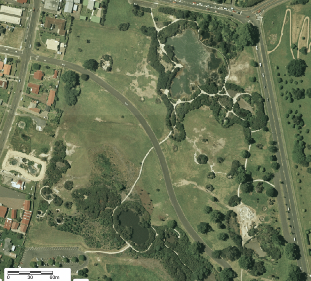
2001 (Pre-eruption) 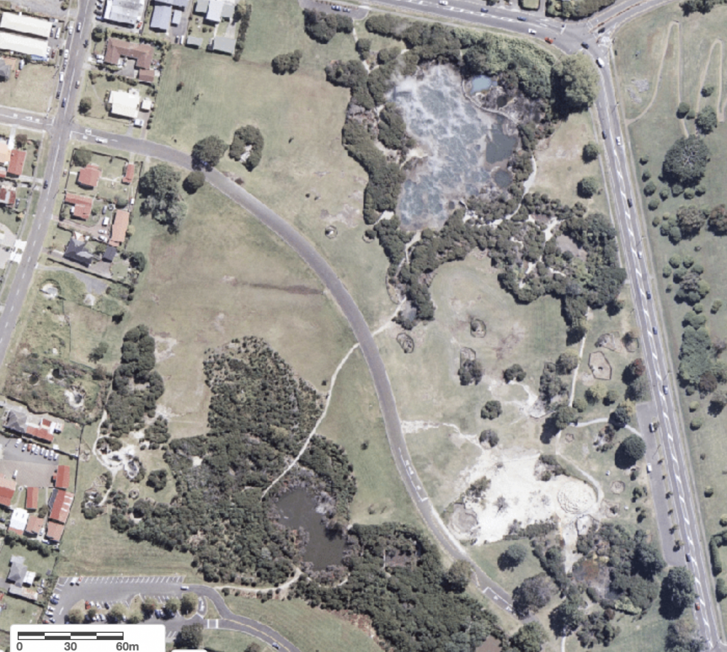
2006 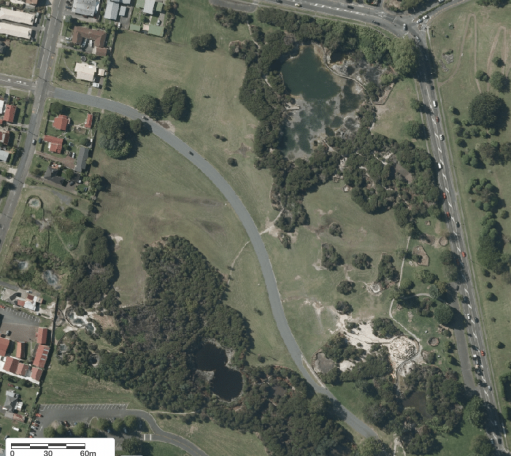
2011 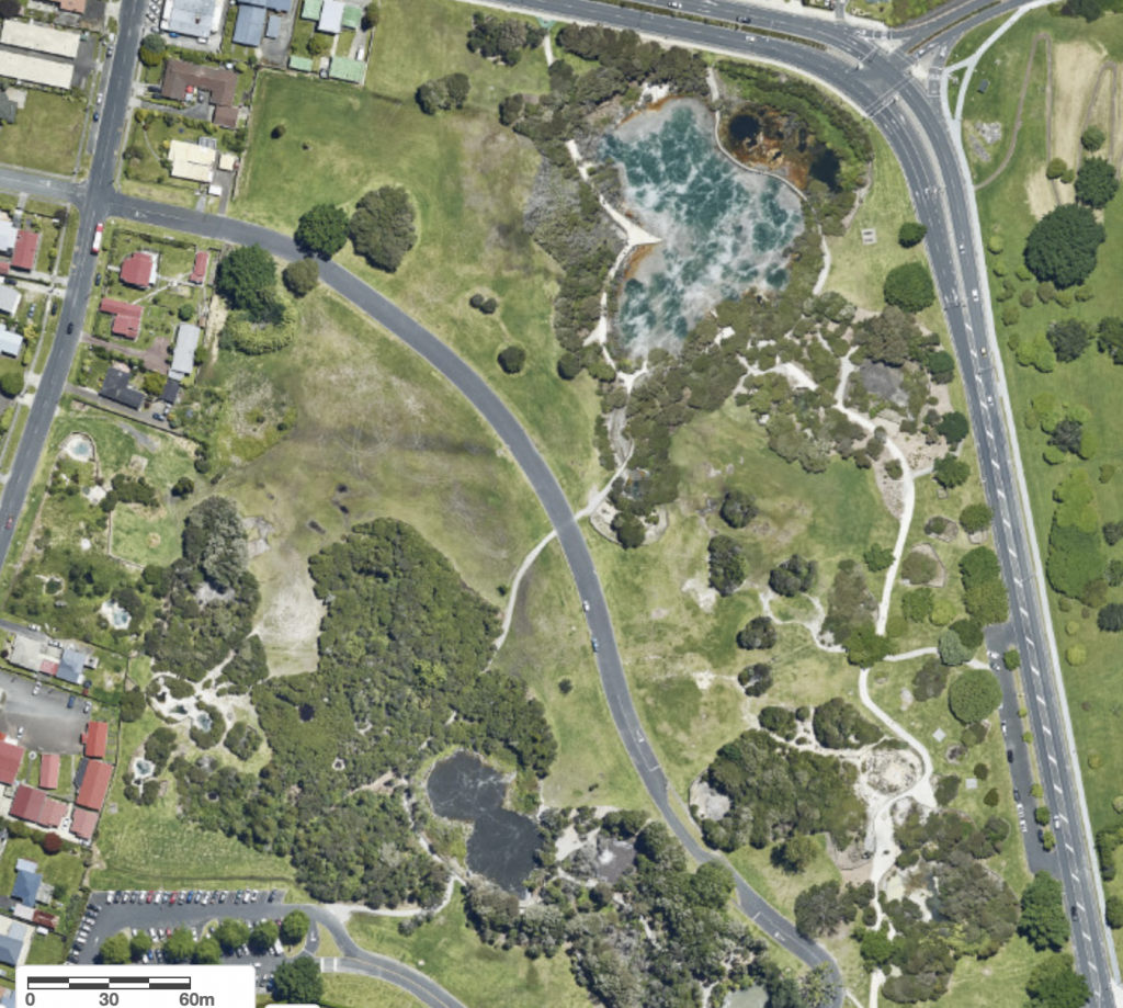
2018

Note on pronunciation-- In Te Reo Maori, the language of the Maori iwi (tribes) of New Zealand, syllables of the words consist of an optional consonant followed by a vowel or vowel pair. No exceptions, even for imported, foreign words. There are only 12 consonant sounds. The letter pairs "wh" and "ng" are considered to be single consonants. The first, "wh" is now pronounced like a soft "f", but originally was more of a "fw" sound. The other, "ng" is described in a pronunciation guide as "sounds soft like singer, not hard like finger." So "Waimangu" should be pronounced Wai-ma-ngu, not Wai-mang-u or Wai-man-gu.