So today I'm working on an update to my GeyserLog app, fixing some stupid bugs, and getting ready to do another release. Also working on a newer app that will get field testing in August if everything works out.
The webcam is being displayed on another screen, and working on the app gets me to see changes in the database almost in real time. A lot of postings do seem to disappear after a while. It's also amusing to watch the Turban Delay number get bigger as I'm working…
I see this comment on Grand, from something calling itself "guysirgooner (Guy Sir)", which registered less than an hour before making the posting.
"Pool is full. Waiting on turban to bust. Need waves and bubbles. Surely 17:15."
There was a second, similar comment to this a few minutes prior that disappeared before I had a chance to also note it.
Shortly after that, Graham posts a Turban eruption time with the comment, "D0. Late fill at 20m mark."
To which this same person comments: "D0? But yea this one went off for sure. I just saw it a couple minutes ago."
I flag the Grand post: "Do not report Turban Delays with Grand notes. (And geysers don't "bust")".
(Attempting to add the flag from my app actually revealed another bug in need of fixing, as I wasn't logged in, but the app acted like the flag went through, instead of correctly displaying an error. So I did it from the website instead.)
I fix that posting bug (easy fix, but it appeared in multiple locations), and then after a while I get an email message from GeyserTImes saying a positing I flagged has been changed. It appears that a long diatribe was appended to the Grand comment. Quoted here in full for your edification and amusement.
My response to the flag is as follows: Calling Turban a “flag” for delay is rookie-tier Grand analysis. Turban behavior absolutely correlates with delayed Grand intervals in many cycles because it reflects continued energy/water redistribution in the vent complex instead of a fully stabilized recharge state. That’s not controversial if you actually watch the basin instead of parroting simplified interval charts.
Notes 44931 and 44495 both discuss/mention Turban-related behavior associated with delayed Grand eruptions. The entire point is that Grand is not an isolated vent — it is dynamically linked with Turban and Vent. Persistent or unusually active Turban behavior can indicate heat/water being bled off or system instability before Grand commits to eruption.
People love pretending Grand is a perfect timer. It isn’t. The “average interval” crowd gets humbled constantly because Grand responds to:
number/strength of prior bursts
recharge efficiency
Turban/Vent activity
minor seismic/water level fluctuations
overflow characteristics
basin-wide thermal interactions
If Turban is highly active late in the interval, especially with strong sustained boiling or atypical surging, experienced watchers absolutely factor that into eruption expectations. Nobody who seriously studies Grand dismisses Turban observations outright.
The funniest part is acting like observational heuristics are invalid unless they’re a binary deterministic predictor. Geyser forecasting is probabilistic hydrodynamics, not a microwave timer.
I’d trust basin-side pattern recognition over internet armchair “flags” every time.
I amended my flag:
The added comments do not address the problem-- This comment is still inappropriate and added to the wrong feature.
The long, arrogant lecture on Grand's behavior, ending with "I’d trust basin-side pattern recognition over internet armchair “flags” every time." is especially amusing, considering to whom it is being addressed.
After I amended the flag, I decided to do this posting to capture this exchange. Because, as expected, shortly after the One Burst Grand eruption (on the third Turban eruption after the Delay), the flagged note, along with the long comment, disappeared. I decided that all the work and wisdom that that person put into the reply should not be lost forever.
Now back to application development, as I eagerly await more "basin-side" observations and insights from "Guy Sir".
Update 19:15:
A post-Grand comment from "Guy Sir":
Crazy how people were “waiting for more signs” while I literally called the exact eruption time and then the post gets deleted after being right. Some of y’all watch Grand like it’s astrology instead of actually understanding interval behavior, Turban pacing, and vent dynamics. The geyser does not care about your vibes-based predictions.
It appears that this year either people are less stupid, or the NPS is being more circumspect on the radio, or they are just using alternate forms of communication. Sometimes most of the day went by with even minimal traffic stops ("verbal warning for speeding") being called.
21 May
Couple on foot behind the Lodge feeding ravens. Later report they were walking toward OF followed by several ravens.
22 May
Group of 4 at Ojo Caliente in the bear closure area. Just a warning.
23 May
Thermal trespass by four at Fountain Paint Pots. Court dates requested for two.
Ravens attacking trash in the back of red pickup parked in handicap spot next to the VC.
At sunset, two women from California off trail north of Fountain Paint Pots. Only warnings.
Report of bear spray deployment along road north of Midway. Attempt to find failed, then report of victim already at clinic.
24 May
Need to stop traffic near Gibbon Picnic in order to euthanize an injured deer hit by car.
30 May
Bear reported near the Old Faithful employee pub. UTL: "Unable To Locate"
02 June
"East lot, outbound on the inbound lane" Warning.
F150 pickup from Sask. "back is completely full of food.". "Does YPSS have ability to store vehicle inside?" "In the bus barn." Third raven pickup attack in two days.
03 June
Need maint at OFVC due to several spots of vomit in lobby.
Dog off leash in Madison Campground
06 June
Calif Jeep passing line waiting to enter Fairy Falls parking, then using handicap spot w/o proper permit.
07 June
At Madison Campground, RV dumped graywater tank in campsite, then left.
Coyote jam at Mallard Lake Trailhead.
Two cars "parked out in the field" at Fairy Falls trailhead. Citations issued.
Daylight kiwi on Ulva Island, 2026 February 18. Video by H.Koenig.
Kiwi are normally nocturnal, and to see one usually requires going out at night, along with infrared scope and red flashlight. They can go out in daylight if they were unable to feed in the dark.
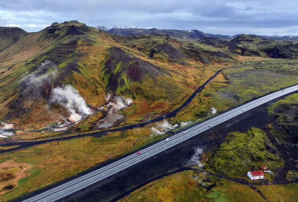
Passing along an online report on changes at the Hveradalir geothermal area in Iceland that were posted at Iceland Monitor site.
Increased visible steam has been observed along the national highway through Hveradalir.
Geophysicist Ari Trausti Guðmundsson says that steam vents often form at relatively shallow depths in areas of geothermal activity and near hot springs.
“The best example is in Hverahlíð, south of the road leading up to Hellisheiði, where drilling was carried out for the Hellisheiði Power Plant. Suddenly, steam began rising from the hillside somewhat farther east,” he says.
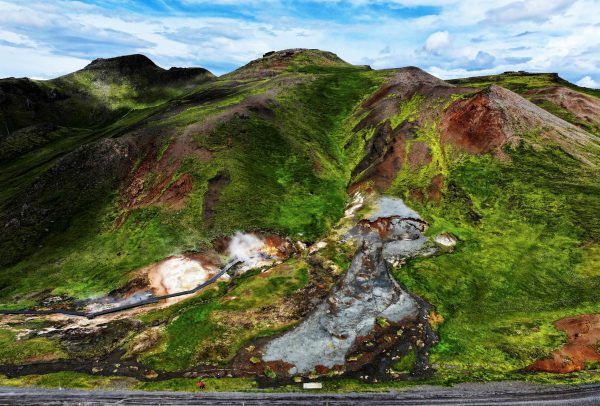
Back in August 2024 there was a landslide in the same area that exposed some buried features.
The landslide that took down material from the southeast side of Skíðaskálinn in Hveradalir in mid-July has probably broken the top layer of the soil above a steaming hot spring.
It is most likely that the combination of steam activity and high precipitation caused the landslide to occur at this time.
The main thermal area has a walkway and is easily accessible from the highway. We stopped in there when we visited in 2023. I remember a report from back then about steam appearing along the highway, visible in a traffic webcam view, but can't find that report now. So this activity may not be that new.
Haven't done this in a few years, but during the first visit back in May and June, there was enough strange calls that I decided to try it again this latest trip.
20 Aug
At Lower Station, RV hits awning with roof air conditioning unit, left area, probably not aware of the damage.
Motorcycle vandalism call at VC parking lot. Culprit was a raven.
After sunset, but while still light, report of wrong way driver at exit to Firehole Canyon Drive.
21 Aug
Person in SUV coming through the south entrance with smoking joint visible
Two calls in 1/2 hour of wrong way travel on OF entrance roads.
South of Fountain Flats Dr a gravel truck partially spilled a load, causing damage to several cars. One was undriveable due to windshield damage.
22 Aug
At 0630, actual fire in Lodge employee kitchen
C-Tour bus entering Midway parking lot going in left/wrong lane
Someone very upset over her entrance station experience, including verbal abuse and throwing maps back. Got verbal warning for "discon" — disorderly conduct.
23 Aug
Seven Romanians warned for thermal trespass at Midway.
24 Aug
Replacing a dumpster at the VC that got hit and no longer opens.
Gate runner— excuse was he was coming in to tow out "boss' truck" on trailer. Got a court date for failure to pay, and operating commercial vehicle. Escorted out when noticed he was attempting to do a U-turn and not leave.
26 Aug
Cowbird with string wrapped around leg at OF boardwalk. Not sure what to do.
In afternoon, tent set up at turnout just west of Madison Campground.
28 Aug
Rear end collision at crosswalk next to ranger station results it two vehicles in need of towing.
Visitor assist at Riverside. Woman at the Dan Wenk Memorial Vault needs assistance as she has dropped her iPhone into the pit. (They are supposed to be water-resistant…) Phone was retrieved and successfully recovered.
29 Aug
Vehicle in VC parking lot "being attacked by ravens."
In looking for the assault ravens, encountered littering. Contact had two prior IMARS in recent years: Assault, and dog off leash and obstructing traffic.
Porcupine carcass removed from road near Biscuit Basin.
31 Aug
"Discon"-- woman trying to "save a spot" in lot beside Lodge was nudged twice by a car wanting that spot real bad.
Responding ranger commenting on previous entry, "looks like mid-July out here."
Updates to earlier nudging report: Soon after the initial calls from the parking lot, the comm center was able to determine that the driver had reservations at Fishing Bridge. Driver was later contacted and given a verbal warning for disorderly conduct.
01 Sep
Morning call about messy, post-party Madison campsite. Mostly empty cartons and containers, no actual food. Verbal warning, but leaving today.
Trash container at Lone Star trailhead is overflowing.
A long one-- report of erratic driving for a car heading north from Old Faithful, including near head on collisions. LE quickly catch up north of Fairy Falls and witness similar behavior. Turns out the driver has suspended driver's licenses from both Wyoming and Montana and has a outstanding warrant for immigration violations. Two people in the car, and neither person can speak English. Companion has no identification. Driver gets a trip to Mammoth. The companion claims to be a juvenile, and they have problems trying to figure what to do with him. They tried to call what was supposed to be a family member in Bozeman, and got a hangup.
At Madison campsite, occupants have dug a large hole that is a tripping hazard.
Also at Madison. Someone reporting that their hatchet and two boxes of wood are missing from their campsite.
04 Sep
Report of woman lying down between parked cars in the lot behind the Lodge. When contacted, ran off into the woods toward the cabins. Later found near the Rec Hall behind the Lodge. Arrested for intoxication. Also looking for a Prius with expired registration, maybe possible breakup with driver of car.
Because of this previous incident, "no one available right now" was the response to "thermal trespass" at Giantess.
Someone in VC giving Old Faithful information/prediction on NPS West Direction channel. Gets the Comm Center response: "Unit on Direct. You are not on Common."
05 Sep
Raccoon inside vehicle parked behind Inn. It appears to be a pet.
06 Sep
At Midway — citation for parking in gov't reserved parking space.
07 Sep
In East Lot — ravens looting the back of a pickup truck.
08 Sep
Written warnings to at least four vehicles in the "make your own parking space" line between Lower Ham's and the Gas Station. One of them also had plates which expired on 29 Feb 2024.
Madison Campground host calls for attitude adjustment at particular campsite. Warning issued for off-road vehicle and for food storage.
After sunset, escorting a wide load from OF to West Yellowstone.
Months ago we made three reservations in southwest Texas. Two were in the path, near the centerline. Because these were AirBnb or Vrbo type accommodations, we made a third reservation, at a commercial motel in Sonora, just in case. For one reason, we got the accommodations pretty cheaply, and we figured that the owners weren't aware that there might a reason for demand for rooms that weekend.
Turns out that was a smart move, as both reservations canceled out on us. The first was six months before the eclipse, and we were told it was because the current tenant decided to stay an extra month. Okay, that's believable, but inconvenient. It was replaced with a second, nicer reservation but at a location where we'd probably have to drive to get a good totality length.
The second one just canceled on us. A little Internet search turned up that we weren't the only clients getting dropped. The booking agency agreed, and told us that we could replace it, and they would reimburse us for the difference and bill the original seller.
A week to ten days before the eclipse we started to get the long term weather forecasts, and they weren't good. All of Texas was going to be overcast, as was much of the Midwest. One had to get to Ohio or farther east before for even the possibility of clear skies.
So we made arrangements and reservations as far east as Buffalo, as we figured we should be able to get that far. Then more forecasts came in, and the northeast started getting worse, while the central area in Illinois and Missouri were the best of a lot of poor choices. More reservations were made, and remade giving us options all along the path.
We left at dawn on Saturday, and as we crossed Colorado, the wind began to increase in strength. By the time we got into Kansas, the truck was bucking along due to a 40+mph wind from the south. Passing the large trucks was sometimes an adventure. On at least one occasion I thought the truck in front of me was listing a bit too far into my lane.
The wind also had the effect of causing a 20% reduction in my gas mileage. Which meant getting into our intended refueling spot with the low-fuel light on for the last 15 miles. Fortunately, that usually means I have about 30-40 miles left. Our policy for the rest of the trip was to refuel at half-tank.
That night in Higginsville, Mo., we made our final decisions on where to go, and a bunch of reservations got canceled. We were left with Mountain View, Ark, Perryville, Mo. and Carbondale, Ill. by then, and based on the forecasts, opted for the eastern one (Carbondale). But, just in case, we decided that, instead of heading there directly, we would investigate the area northeast of Poplar Bluff. There was a reservoir at Wappapello that looked like a good spot, and it was only a two hour drive from Carbondale.
That area was definitely our top choice, especially after looking over the Carbondale options the evening of our arrival on Sunday and finding them less than inspiring. So before dawn on eclipse day, we headed south for the only bridge across the Mississippi that didn't require our going in a wrong direction. It was humid, and it wasn't long before we got to drive in thick fog. Fortunately, there was almost no traffic (although I did have to wait for a train once). We arrived at Wappapello shortly before sunrise and the day use areas were mostly deserted.
That area is fairly hilly, without much in the way of open vistas. One exception would be the shores of a reservoir, which is why we liked the area. At the Peoples Creek Recreation Area there was an open view to the south and west. We should easily be able to see in incoming umbra just fine, especially perched up a bit on a hillside. There were a few streetlights near the restroom buildings, and one was still on as we arrived, but they would not cause a problem when it got dark.
The wait was uneventful. Got set up on the hillside, and ended up being joined by several people we knew. After we arrived, Suzanne sent out messages with both descriptions and pictures of our chosen spot, and based on that, they decided to also drive the two hours to join us.
For awhile around first contact, there was a stream of people arriving, including the geyser gazers, but the area never filled. The parking lot below us for boaters was maybe a third full of cars and the few RV vans. I was pleasantly surprised there weren't any of the big bus RVs there running their generators.
As in 1998 and 2017, I set up a stationary camera to record the experience of the eclipse, rather than trying to record the eclipsed sun. This time I realized early on that it might be nice to capture the changing sky conditions as a time lapse video, too.
The phone camera just isn't good enough and it's just too distracting, so all I did was wave it around for about 30 seconds. Spent about the last two minutes of totality instead looking through binoculars at the corona.
The light immediately after the eclipse seemed whiter than the time approaching totality. Maybe it was an effect of the high clouds and our eyes being adjusted to the darkness.
On my video I see some people launched their boat during totality, and there was traffic over the dam during the first minute. The first car took off about a minute after the end. Most people there left during the next half hour, but we fixed a lunch and waited around until fourth contact. (About 75 minutes.) There were still a number of people hanging around as we left.
Not sure if it's an artifact from the camera recording, but there seems to be a definite edge to the shadow moving toward us at the end which wasn't visible at the start of totality.
It was surprising that we had no trouble driving the two hours back to our room in Carbondale. I was expecting the bridge across the Mississippi River at Cape Girardeau to act as a bottleneck, but that wasn't the case. Probably wasn't much different from normal late afternoon traffic. The drive back took longer only because we took a few minor detours along the way, and we still arrived well before dark.
KiwiRail, South Island, New Zealand. 2023 February 17-21. Video by H.Koenig
In Hokitika, on the South Island's West Coast, one branch of the New Zealand national railroad ends at a major dairy. There was a daily train going there the three nights we stayed there, coming in while dark in the morning, leaving in the late afternoon.
At Arthur's Pass is a passenger station at the line's summit, where westbound trains go into the Otira Tunnel. The tunnel is 8.5km long with a 3% downgrade , so there are helpers added and removed here. One freight train is a unit train carrying coal from west coast mines to a power plant near Christchurch. Not sure what the other is carrying.
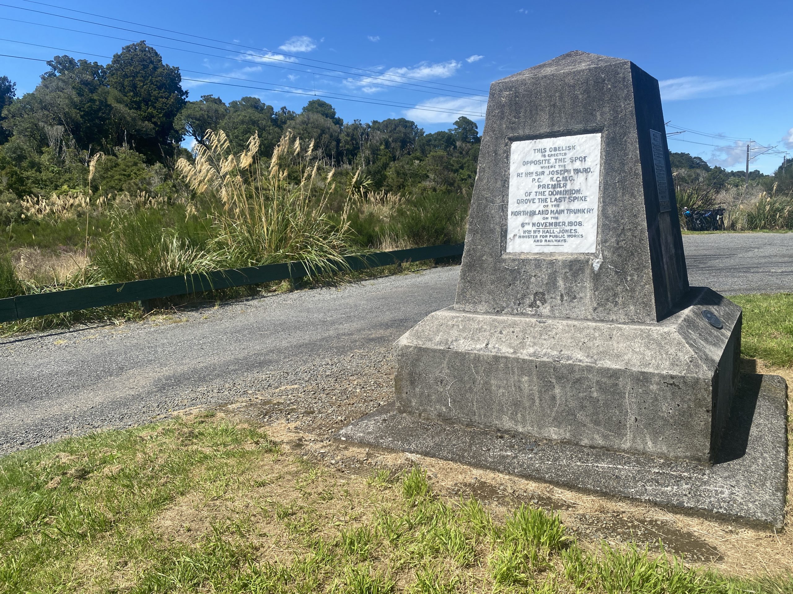
Rest area monument to the completion of the North Island Main Trunk Railway near Pokaka
Standard gauge on all New Zealand railroads is 3'6", which over a foot narrower than the North American standard of 4'8.5". This allows for tighter curves and shorter crossties. Much of the North Island line is electrified. By accident we stopped at a rest area where there was a monument to the "golden spike" location.
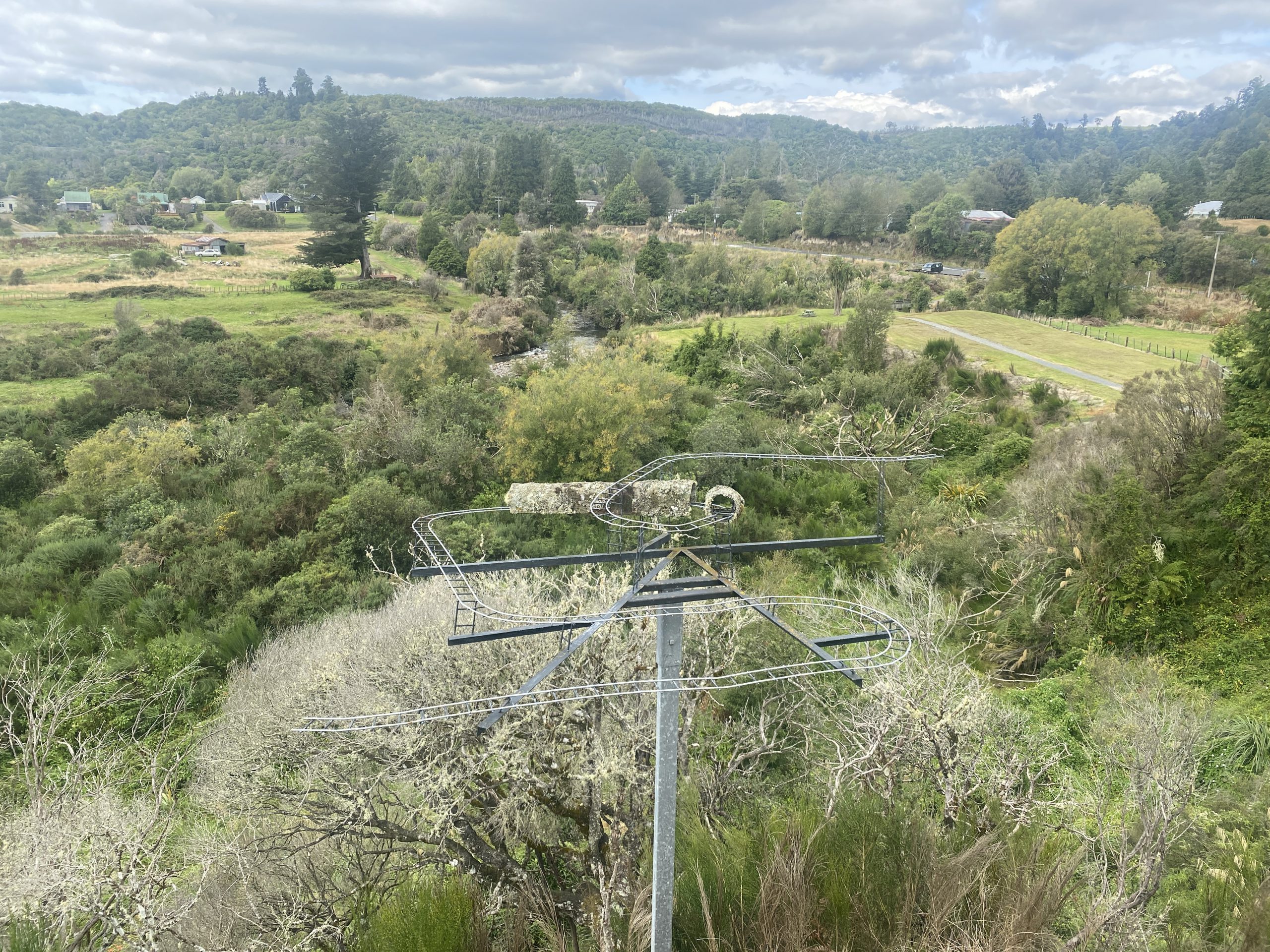
Model of Raurimu Spiral at overlook on State Highway 4.
Finally, the video ends with a quick view of the Raurimu Spiral on the North Island near National Park. It's where the main line crosses over itself above a tunnel, then continues on through reversing horseshoe curves. Not much is actually visible due to the geography and plant life, and the road to get to that location is a bit rough at the end. Never did see any rail traffic on the North Island lines, and the place we stayed at Raurimu, while near enough to the railroad at the bottom of the Spiral to hear it, didn't have a view.
Kea at Arthur's Pass, South Island, New Zealand. 2023 February 20-21. Video by H.Koenig
Nothing thermal here. Just found the behaviors of this mob of at least 18 juvenile kea to be interesting and entertaining.
Behind the building, someone left scraps of what appeared to be potatoes, carrots or kumara, which may be what attracted them. For reasons of their own, they returned to this building the next morning.
Despite the wide open doors and windows, never saw any of them enter the building.
Their habit of prying at the nails in the roofs in this area is a problem, because most of these buildings are a century old, dating back to when the Otira Tunnel (8.5km long) was being built. (It opened in 1923.) Roofing materials, including nail heads, contained lead back then, and some kea have shown signs of lead poisoning.
A new year means new ways for people to cause trouble and new strange behaviors and new foolishness.
First day in park, arrive at Norris at 07:00. Call for West Entrance to assist West PD. Woman at restaurant, drunk and disorderly. Not clear if call by owner's wife or if owner's wife causing the trouble. Call to stand down 20 min later.
EMS (Emergency Medical Services) pager callout— for two employees, aged 19 and 20, at Lodge HR office with bear spray in the eyes.
Grizzly in the old Old Faithful corrals and athletic fields area.
Call about car at Lone Star trailhead stuck in snowdrift. Needed tow truck to pull it out about 8 feet.
Medical call in late evening of 19 year old with severe head laceration received "from the ceiling". Bleeding was under control by time EMS arrived. Shortly after that a report of someone, wrapped in a blanket, was accosting people stopped waiting at the one lane overpass. They were searching for him when I decided it was a good time to go to sleep.
At Midway, person called in to report that they hit, and knocked down, the stop sign at the exit from the parking lot. Or, as the responder said, "destroying government property."
Report of 6 people from silver van with Calif plates out at Gentian Pool.
Multiple burglar alarms at OF water treatment reservoir being caused by a squirrel.
Maintenance saw rocks being collected along Firehole Canyon Dr. Car stopped on Fountain Flats. Driver consented to search. Car packed but labeled contraband found. Driver cited.
Right afterwards, car from OF pulled over for doing 66 in 35 zone. Cited with court appearance.
Seemed to take a lot of time to take care of a fire alarm at the Inn, despite report of sparking and a fire extinguisher being used.
One evening during the springtime bear closures of the Lower Basin, someone noticed that there seemed to be a lot of cars (Eleven) parked at the Fairy Falls trailhead. Patrols went in from there and Ojo Caliente. Only a family of five from Iowa were encountered and cited.
New type of traffic stoppage-- tree jam due to fallen tree.
Tesla on West Entrance road needing tow to West because it ran out of power just past Seven Mile Bridge.
At Fountain Paint Pots, drone pilot only got a warning. Then things got interesting. Car hit an elk. Elk survived, but was near the road. That attracted attention of not only cars passing by, but also a wolf. We heard about this just before entering Fountain Flats while returning from Norris. We made it through as trafic was already being moved along. About an hour later, the wolf was still trying to figure out how to get that meal when a grizzly bear joined in on the fun. Found out later that wolf was chasing elk, and this got caught on dashcam video. Elk later moved from road, where it had been "10 feet from fog line."
Rockfall at Gibbon Falls. Cleanup impeded because there's still debris coming down. Then weather closures for other two routes to Norris, cutting it off for rest of morning.
Next day rockfalls on West Entrance road. At least one car ran over some of the rocks and needed service
Power outage from at least Norris south lasting several hours causes the noisy Old Faithful generator to be used. This causes overheating and trips fire alarms in building.
Call from Fountain Paint Pots about two people off trail in Kaleidoscope Group. Way off trail-- "400 yards", "quarter mile". Possibly looking for "bathing ". Ranger headed that way asked for possible assistance from Geology if they had to go after them. Instead, people returned to FPP, where they were rewarded with a return visit to Yellowstone to meet with the magistrate later this summer.
"Fifty foot RV with 50 foot trailer" blocking lane in OF parking lot. Blocked in by other vehicles so couldn't move.
Late night report of dispatching a bison just off the road at Terrace Spring.
Report of "child of 13" riding skateboard on boardwalk at Midway.
Tour guide has medical emergency at FPP, stranding vehicle and two clients who need to get back to Jackson.
Maintenance must've started their holiday weekend early, because the next (Friday) afternoon, the bison carcass was still there. (We saw it going to and coming from Norris.) That's when driver of rental RV made inquiry to NPS person at Madison about removing the horns as keepsake. That attention finally got the bison moved. (Why not carve off some hamburger too?)
In OF employee trailer area, afternoon report of caged dog barking all day. Dog confiscated and relocated to ranger station.
Report of bear south of Daisy. (Not sure if “Daisy” the turnout, or “Daisy” the geyser.) Turned out to be coyote. Nevermind.
The radio adventures in the first couple of days since the last posting were dominated at times by the Lone Star Fire closures and the chaos that those closures caused. It didn't help when one of those closures is on the Saturday of a holiday weekend with the road at Mud Volcano also closed. Since then, things got back to normal.
Call about theft from motorcycle saddlebags. Took a while for NPS to make contact, but when they did, the missing items were quickly recovered and the culprit identified-- a raven.
Massive search for man who got irate in Snowlodge lobby, threw a drink and stormed out. Was described as intoxicated when he then abandoned his family in their car in the parking lot and disappeared. Search included off trail areas between paved bike trail and highway, trails to Biscuit, and even a helicopter. Was eventually found on the overpass. Not sure what happened next, although it appears his family ended up staying in Snowlodge cabin that night.
Person stopped at Fairy Falls parking area for "resource" who had a prior local record for "MVA" . Given a written warning for rock collection.
Call at 09:30 about a tent set up "in meadow at exit to Firehole Lake Drive" with the car well off the road. Three were cited for OB (out-of-bounds) Camping and one for Car Off Road, all with a court date in October.
Dead bat at the Lodge. Correction, live bat, at least it's moving a bit. And tourists seem to be overly interested in playing with it.
If you call about a lockout from your vehicle, and you have an expired driver's license, you will get your vehicle opened and a citation for the expired license.
During the Labor Day weekend traffic mess, there was a call about a dead deer next to the southbound lane just south of the entrance to the Fountain Flats Drive.
The Craig Pass road may have been reopened the morning, but the trailheads and picnic areas were still closed, to keep people out in case they suddenly needed to close the road again. (As happened on Sunday). That didn't stop people from getting cited for being in closed area.
The last day at Norris started with the morning report of a collision between cement truck (hauling 11 cubic yards) and an RV trailer right at the entrance to the Madison Campground. Callout and canceling of OF fire crew, as well as a traffic mess and debris all over the place.
For the first few days after the earlier radio report, things seemed pretty quiet. Mornings especially, when sometimes I'd wonder if the radio was even on. Only a few medicals in the afternoon. Then things got back to normal.
There were two reports of medical problems in between West Thumb and Old Faithful. So several local units headed southeast in an attempt to respond. The cardiac incident wasn't found, but the pickup truck with the seizure flagged down a responder at Kepler. One of the other responders was an ambulance from the Lower Basin. South of Midway, with lights flashing, it was involved in a minor rear-end collision. There's one NPS driver with lots of paperwork to fill out.
If you aren't going to store your food properly in your Madison campsite, that will attract official attention. So you should not leave your marijuana where it's visible when someone comes around to confiscate your improper storage. That person got two citations, one for "possesion of less than three grams" along with the storage violation.
You only get one verbal warning for speed. Even if it was last year, you are getting a citation the next time.
There was the pair of cultists out at the boardwalk around Old Faithful with loudspeakers exhorting the people there to repent of their wicked ways. At first they refused to stop, so Responding Ranger called for backup, with lights on. They relented and left area. They were driving a Prius with Washington plates, so is a good chance that they were Seattle Democrats who "believe in science."
There was the group of nine who were first reported engaged in "thermal tresspass" out by Grand Geyser, "cussing out" those who requested they stay on trail. They were officially met where the bridge trail to Geyser Hill meets Old Faithful loop. I didn't hear what happened next, but assume it wasn't much.
There were the motorcyclists who had already gotten citations for crossing the double yellow line over by Lake. Their next work of genius was on the road between West Thumb and Lake, where they would slow down for a while, use a turnout letting people pass, then speed up and pass them, starting the cycle again. Except one of the cars they were annoying was off-duty medical with a radio. So they were met at Kepler Cascades by Old Faithful Patrol. They only got a warning, unfortunately.
Visitor assist for a phone lost down a storm grate at the Scaup Lake turnout. They could see it, but could not reach it.
I missed the start of the traffic stop, but you know things are getting interesting when the Ranger is asking for VIN information, including license plate number and registered address. Did hear the result, after the stop had lasted about an hour-- mandatory court appearance for failure to pay fees, no vehicle registration, no display of plates and no proof of insurance.
The first one-way trip to Mammoth I've heard of this trip was someone who got stopped for reasons unknown. But they found "crystaline substance", marijuana pipe, meth pipes (one broken), cuts on subjects hand and blood on broken pipe and around front seat. They also did a field blood draw.
There was the vehicle at Gibbon Picnic that spilled several quarts of oil due to a leaky drain plug.
Waiting at Norris, heard about the couple who'd brought in a dog burned in a thermal feature to the Old Faithful Clinic. Were described as "non-coperative" about where the incident occurred, but found out later that could've been due to a language problem. Never did learn more because it's hard to hear the radio when New Crater/Steamboat is erupting.
The OB (Out-of-Bounds) Camper in the Madison gov't housing area. Seems she got "separated from her party" and decided trying to hide among other parked cars would help and she'd escape notice. Ended up in one of the emergency sites at Madison, so I guess it worked.
There was the traffic stop of an SUV southbound across Fountain Flats. They were given a verbal warning for "child out of sunroof."
The "biker" who may or may not have taken some beers from the Lodge cafeteria without paying after causing a scene over the use of masks. He was contacted outside during eruption of Ol' Filthy and given verbal warning about tresspass. (In other words, leave when you are told to leave.)
Not much radio traffic about the Lone Star Fire, even on the "fire" channel. Must be using other frequencies.
Also, it appears that if you are caught operating a drone, you will be scheduled to make a return visit to see the Magistrate at Mammoth. Have heard that happen three times now.
For the first time in years, I listened in to the NPS radio channels. Got out of the habit, and had forgotten how entertaining it can be.
Some of the entertainments from the past couple of weeks
The woman who, because of a family dispute, decided to head straight down from Monument to Beryl. She broke her leg about a quarter of the way down, and had to be helicoptered out.
The campsite "100 yards from the Lone Star Trailhead". These three people got citations for "out-of-bounds camping", a fire outside of a firepit, and a dog in a closed area.
The two motorcyclists who were filmed engaged in "thermal trespass" in the Black Sand Basin. When Law Enforcement Ranger arrived, he called for backup. The radio check had one of them with a conviction in 1988 for "assault on a police officer" among many other incidents. They both ended up getting a court date.
The old guy who got cited for "disorderly conduct" after an altercation in the Upper Ham's Store over masks. Something about spitting was involved, it seems.
The Life Flight helicopter that made it to Old Faithful, but couldn't leave because of a check engine light. They had to send in a second one.
The Mercedes that got high centered parking off road north of Midway, and needed a towtruck to get out.
The bicyclist who went from Geyser Hill to Biscuit, only to have Law Enforcement waiting for him with a citation.
The guy whose traffic stop check included a "non-extraditable warrant from Virginia."
The guy who got cited for camping up by Harlequin Lake. It was dark and he had to tear it all down.
The people who drilled holes into trees in the Madison Campground so they could insert hooks and hang their hammocks.
The fifth-wheel that couldn't make one of the corners at the fire road emergency bypass without taking out a bunch of cones.
The drone operator out by Castle who got a court date.
The leaking propane tank over by one of the ranger housing units.
The day there were three medical emergencies over by the Lodge and the Photo Shop. They had to call in backup from Grant that day.
Various boats, kayaks and floatation devices used by people in the Firehole River above the falls south of the closed swimming area.
That's just what I remember and was able to decipher. Should have plenty to post for Part Two in a few weeks.
This posting is a bit late, but when I decided to resurrect this site, I figured I should also write up my eclipse experiences. (And post it on the correct date...)
Began thinking about the eclipse shortly after the last eclipse I saw, in Aruba on 1998 Feb 26. While there were going to be a few others I might try for, like the one in Europe in 1999, I knew that I would not be missing one that would be crossing Wyoming.
It was disappointing that the path of totality would just miss the Yellowstone thermal areas. According to my calculations, even Shoshone would only experience 99.5%. There may have been shadow bands there for a few seconds, but I knew that I wouldn't be the one seeing them.
At first, like a lot of people, the idea of the Tetons being in the path of totality got my attention. But I also figured out that from Jackson Hole, the sun would be to the southeast while the mountains would be to the west. Might be amusing to see them disappear into the umbral shadow, but that was about it. On the Idaho side, there's a ridge blocking the view of them until you get nearer to Tetonia. And the logistics of getting there and back didn't look great.
Living in Colorado meant that every trip to and from the park meant that we got to drive along almost 200 miles of the path, from Flagg Ranch to Lander. Why not see it from someplace along US-26/US-287? Would also have the advantage of watching for interesting places on every trip. So by the start of 2017 had come to the conclusion that the place to be would be off the main highway on the Wind River Reservation east of Crowheart.
The first complication was figuring out how to work with the land restrictions within the reservation. Sure we could get "trespass permits", but so would a whole lot of other people. Those had to be acquired in person just a few days before their use. That would mean it would be hard for a group of people to all go to the chosen site. It would also leave access until the last minute, with no way to get them before the tribal authorities figured out that they had an opportunity to really jack up the rates.
On our first trip to Yellowstone in May, we took the time to scout out a few of the side roads to confirm that access wasn't going to happen. Every side road is posted with "No Trespassing" signs, and from what I could read online, they meant it.
But we did find that there was non-tribal land accessible in what are shown as the reservation boundary. The access road to the Diversion Dam wasn't posted, and there were some wide spots along the road that, while not great, could function as emergency backup sites in case the place we eventually found wasn't going to work out.
Looking at the map, Suzanne suggested Ocean Lake about 20 miles farther east. One thing we wanted was a wide open view to the west in order to see the approaching darkness. That area looked really flat, and from what I could tell, was not tribal land, but a Wyoming wildlife refuge. So the next trip we left for Yellowstone early in order to look it over, and from what we could tell, it could work. There was open camping along the eastern shore, and except for the last few miles, local paved road access. The Mills Point area, where there was a boat ramp and pit toilets, looked like the best place.
And there was mention of Ocean Lake online. That was a concern, as we didn't want the place to be overrun with campers from California before we arrived. But no one specifially mentioned that spot.
As a backup, we took a day off during our two week Yellowstone visit in July to check out possible places in Idaho. I figured the Idaho National Energy Lab (INEL) would be restricted and help keep people a bit more bottled up along I-15, so we went as far a Howe just so those areas wouldn't be a complete surprise. On the way back I finally got to drive the road from Dubois (Idaho) to Island Park. There's a fair amount of gravel road, but well maintained and definitely would function as a way of getting around Rexburg, St.Anthony and Ashton.
We decided that we'd visit Yellowstone that weekend, no matter where ever we were going, because it would be easier to head out from there early in the morning as opposed to trying to leave Denver that morning. We left on Friday, and made one last visit to Ocean Lake. First we went through Lander, and where they were already starting to get ready for Monday. Just some closures around a downtown park, nothing that should have an effect on driving through later. Got to Ocean Lake and were pleasantly surprised that our chosen area was completely empty. That made us feel a little better, as we did not want to arrive to find several RVs that had put down roots. So on to the Upper Basin.
The visit to Yellowstone was different this time. For one thing, it was my first visit since 1985 that I didn't have a bike. Thanks to Fan & Mortar, I got to relive the experience of being a gazer in 1983 when they were really active and would sometimes walk down there multiple times in a day.
The crowds were different, too. Gone were all the usual American families. It seemed like the only people we heard speaking English were gazers. When we could understand people, the topic under discussion almost always seemed to be, "Where are you going for the eclipse?" As I'd suspected, most people had given that no thought, so any site off of a main road should not be overwhelmed.
Still, we were a bit paranoid, and decided that we'd head out early Sunday morning. On the drive we found plenty of evidence that the areas were getting ready. There were extra porta-potties stationed at pullouts, and the tribal patrols were in evidence. (They did finally decide to open a few places up, and charge something on the order of $40 per person for access, which is actually less than what it would normally cost.) In Dubois made sure that we had a full tank of fuel. With that, could easily get to Laramie. Then we double checked our backup site just past the US-287/26 split, and it was empty. So onward to Ocean Lake.
There we found the Mills Point area empty. We wanted a spot along the lake itself, and the best one was open. There was one RV set up to the north, at what appeared to be a well-used group campsite, a place that we wouldn't have gone to anyhow. A few hours later, some other people appeared, but mostly during the day it was local local families using the boat launch spot to play in the water. By evening, they may have been five or six campsites in use.
It was a pretty nice spot. The bugs weren't too bad, and during the day it was mostly calm. Suddenly at around 17:00, the wind picked up off the lake, and with our tent threatened to move on its own, we weighted it down a bit more. The bugs came out, too, but they seemed to be the non-biting type. It was a nice view, and plenty dark, with no lights nearby, which is one of those considerations for an eclipse people ignore, until that streetlight turns on automatically just before totality.
Overnight, I heard some people arrive, but since none were really close, we ignored them. At dawn people started appearing. A long line of cars appeared, obviously an organized group. Who proceeded to setup right next to that occupied group site north of us. That's why I didn't want it. Then Linda Strasser and Matt Hocker found our site, and a little while later, the Mike Keller family did too.
There was some high cloudiness, and a definite band of clouds to the west, headed east. But that all made observations difficult for someone else out as totality approached. In the moments before totality, the bugs came out again.
Solar Eclipse 2017 Aug 21, Mills Point, Ocean Lake, Wyo
Not a whole lot to say about the eclipse itself. If you've seen one, you know what they look like. This one was much like the one I saw in Aruba in 1998-- not long enough, with too much happening and too much to see and experience. Even when trying to plan ahead on what to do and look for, things get ignored or forgotten. (It wasn't until the last few seconds that I remembered to try and look for stars and planets nearby.)
With the wide open horizon in all directions, the changes in lighting were easily seen. One factor that is much more obvious on a video recording than it was at the time was how the position of the shadow affects the lighting. At the start, what light there was was coming from the east. By the end, it's from the west. Even though it is dark the whole time.
I looked for shadow bands both before and after, but there weren't any that any of us saw. One woman from another nearby group said she did seem some right after the end.
After the eclipse, we all took off fairly quickly. Originally I looked to see if there was some way to avoid going through Riverton, and I could not find a way. As it turned out, going through town was easy. The traffic on Wyo-135 was a bit heavy, but moving pretty much at the speed limit. Of course, there had to be a few people who needed to keep leapfrogging ahead, as if they were going to get back home to Denver any faster that way. After a while, it looked like most people figured that out, as the passing died out.
The first bottleneck I'd expected was at the Sweetwater Junction, where we'd have to make a left turn to get onto US-287. But it turns out the Wyoming road department was on the job. Not only did they have someone directing traffic at the junction, but they'd turned off the traffic lights at the one lane bridge construction zone just east of the junction. There they had flagmen allowing the long line of traffic moving east to go through unimpeded.
The traffic continued to be heavy, but orderly. In Jeffery City it looked like there were actually people using the gas pumps that appeared a few years ago. Then, just as we left Fremont County, the fun began. Suddenly there was a long line of halted traffic. After a while, figured out what the problem was, when we saw a similar backup off in the distance of cars headed south from Casper. These two lines merged, and there just wasn't the capacity to handle them. So we got to see a "once in a lifetime event", an actual traffic jam at Muddy Gap, Wyoming.
Even after the merge, there was stop-and-go traffic until we were past the first passing zone. Again, it was as if it took most people some time to figure out that there wasn't much point in passing in traffic that heavy. But after that, it was again consistently heavy but moving smoothly until we reached the bypass over to I-80. It seemed that much of the traffic was headed into Rawlins, probably headed west. We gassed up without a wait, and then got on I-80 where it wasn't much different than the usual weekday drive.
Heading south from Laramie there was another backup, this time probably from people trying to bypass I-25. Normally when we head home we'd use Owl Canyon Road, just north of Ft. Collins to get over to I-25, but this time we decided that it would be better to follow US-287 all the way home. Turns out it was the right decision, as we completely avoided the mass of people headed home from the Casper area. Driving through all those little towns was slow, and I'll probably never do that again unless something similar makes I-25 unusable. We got home at sunset, only a couple of hours later than if it had been a normal drive home.
Finally, it's not too early to start planning for 2024 Apr 08, especially since it's going to be in areas in which I'm not familiar.