
Posted on
Posted on
Posted on
Mauna Loa and Kilauea
Our trip to Hawaii had been planned way back in August. By then, the activity at Kilauea had settled down, but we still figured we'd spend a couple of nighttimes there in the hope that it might be doing something. So it was a pleasant surprise to have Mauna Loa start erupting on 27 November, less than three days before our arrival.
01 December
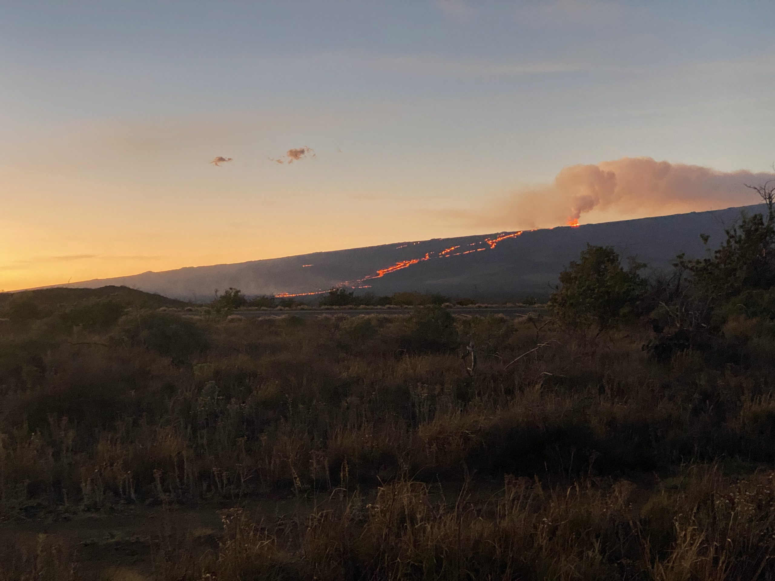
The morning of 01 December we headed out around 02:00 from Kona, for the Saddle Road, not knowing what to expect. As we approached the junction of the western end of the Saddle Road, we could see red glow off to the east.
We did know that the shoulders of the road had been closed to stopping along much of the top where the visibility was best. We arrived at the Mauna Kea Recreation Rest Area where there were a number of people watching the eruption. There was enough of a view that we didn't leave until after sunrise. During the night there was a steady stream of people stopping for a quick look, then moving on. I am guessing that a lot of them were tourist heading to one of the airports for an early morning flight on the other side of the island from where they were staying. Many people dressed in shorts and light jackets, while at that altitude (6500ft) it was decidedly cool.
After sunrise, we proceeded onward to find better places for observations. Did notice a bunch of cars pulled off at the junction of the Old Saddle Road and the highway, just west of the Puuhuluhulu trailhead. That junction looked like a possible viewing site, as did the trailhead. Didn't stick around, though, but drove on up to the Mauna Kea visitor center at 9200ft.
From that location there was a nice view across the saddle of the smoke from the main eruptive vent, Fissure 3. There was also some evidence of red glow along the lava stream coming down the mountain. Was probably another good view in the dark.
When we picked up our rental, we were offered the opportunity to upgrade to a Jeep at no cost. Normally renting a Jeep would have added several hundred dollars, and we probably wouldn't have put it to enough use to justify the expense. But here the only drawback would be lower gas mileage, so we took the opportunity. Now we were about to put that opportunity to use. In order to drive to the top of Mauna Kea, a four-wheel drive vehicle is required. It's not because the road is gravel much of the way, but because it's extremely steep and possibly icy. The paved section coming down from the Visitor Center has a sign with "17% grade" on it, and the road above is probably steeper. Low gears are required. That also helps filter out much the tourist traffic.
As it was, the road was closed because it had snowed the previous day, and the authorities wanted to check the road for icy conditions before opening. But we didn't have to wait long before we were on our way up.
It's a long, slow drive, and the view is impressive. You don't really see the telescopes until you are near the summit area, because you are just too close and it's that steep.
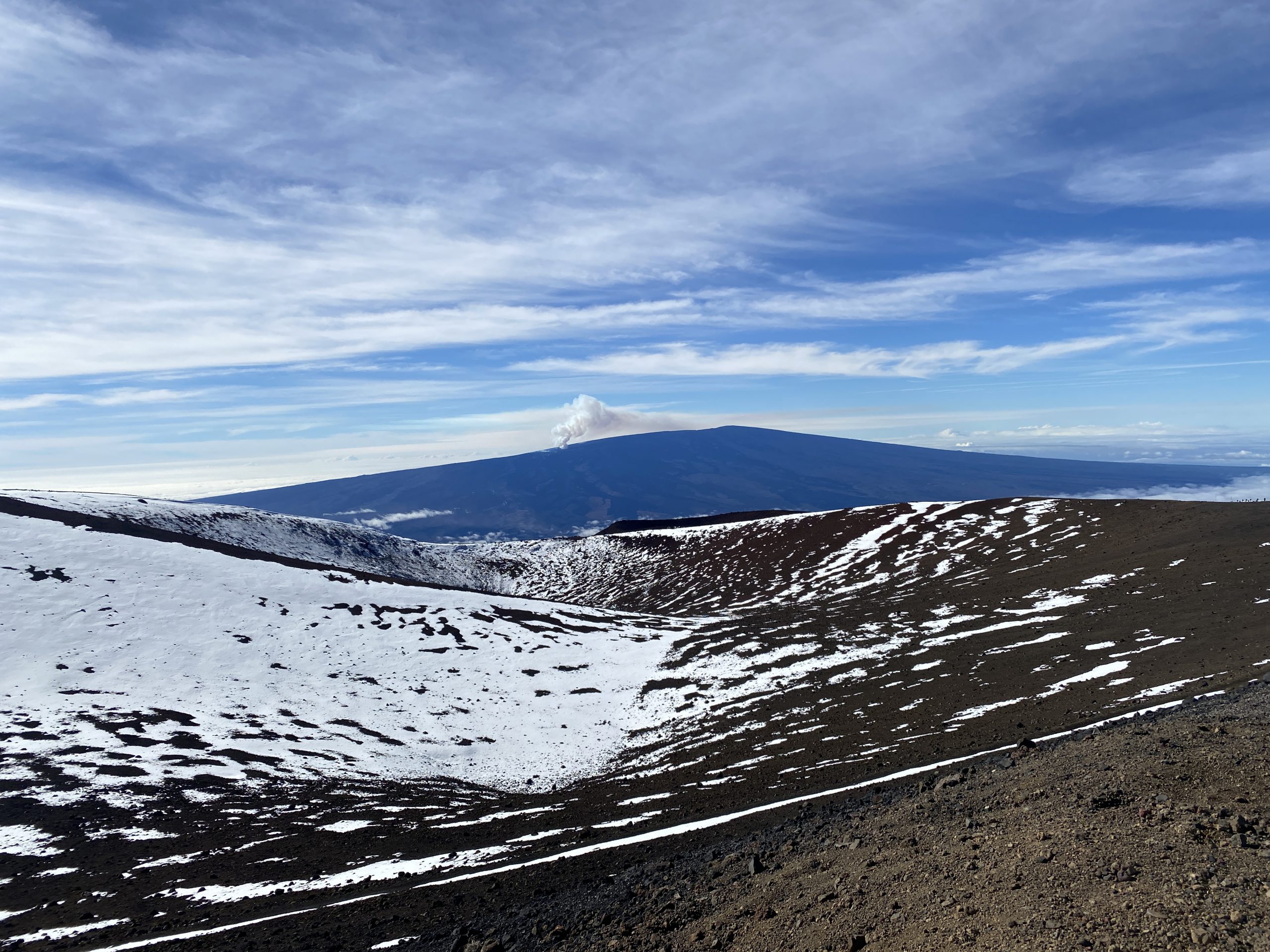
We spent several hours up there. There was still snow piled up where it had been plowed. It was clear up there, because we were well about the cloud layer, especially the clouds coming from the east that covered Hilo. There was little wind. Haleakela on Maui was a huge mass below us to the west. Most of the time, we had the area to ourselves. There were a few vehicles parked at the observatories, and a few people there going about their business. Several times people drove up, snapped a selfie or two, then headed back down. In one case I don't think they even bothered to get out of the truck.
By the time we left, I was starting to notice the elevation (just under 14,000 feet), despite having been in Denver only 24 hours earlier. Definitely did not want to do the short hike over to the actual summit. The drive down was no worse than the drive up. At the bottom, they will do brake checks and make people wait until they cool down a bit. Ours were just under the limit, which was surprising as I wasn't using them much.
Back on the Saddle Road, we noticed a lot of activity along the road as we headed back to the west. The Old Saddle Road jct was being coned off with lots of flashing lights from official vehicles.
We learned about what was going on when we got back. Turns out the authorities were in the process of turning the old Saddle Road into an observation area. From the junction across from the rest area to that exit junction was about 5.5 miles long. It was now one-way, to the east looking at the lava flow, with a low speed limit where the right lane was for parking/observing and the left for travel.
02 December
Headed out again in the middle of the night. When we got to the Rest Area, we took the side road to see what was it was like. There wasn't much view for the first couple of miles. The best views were in the last mile or so. The lava flow all the way down from the fissure was visible, but the base of the fissure was hidden by topography. We didn't stop, but headed on back up to the visitor center. All along the lower part of the Mauna Kea Access Road people had pulled over to the side to watch the activity. Higher up, there were groups of vehicles at various turnouts, too.
From the visitor center, we hiked to the top of Puu Kalepeamoa, a cinder cone just across the road that rises up an additional 200 ft. The view from there was ideal. The activity from the fissure was visible, as well as the full length of the lava flow. It was a bit breezy, not surprising considering how exposed the area is.
03 December
Another middle of the night observation. This time we only went up the Mauna Kea access road to the Mana Rd junction, the last place with a view on the lower part of the road. Going down the slope slightly got us away from the Canadian expounding on his experiences with heating with wood stoves, and from from all the lights of the selfie takers. Sitting on that slope we had a wonderful view of the full extent of the lava river, along with the lights of the vehicles moving along the roads. It looked like we could see the lava flowing down the channel at various bright spots.
04 December
Changed accommodations over to Volcano, so we went to the Kilauea overlook in the early morning hours. That was something we had done on the previous trip, and was planned for before the Mauna Load eruption started. Arrived around 03:00 to a diminishing crowd. Unfortunately, the last two people to leave took a half hour trying for the perfect selfies with both eruptions in the background. (Is that the point of the automated cameras and their annoying countdown beeping?) They had their stuff spread out all over the place before we arrived, and as they gathered it all up, discovered a lens cap got lost. Moving their stuff was "totally disrespectful, as we are locals." Spent the next ten minutes looking all over bare, rocky ground for it. For about twenty minutes after they finally left, we had the area to ourselves before people starting showing up for sunrise. A much quieter, less well lit, and less self-absorbed crowd.
Mauna Loa was the more interesting of the two eruptions. We could see variations on the fountaining which caused various parts of the fissure to brighten on occasion, Kilauea had quieted down. There was some convection in the lava lake, but unlike last March, there wasn't any activity along the edges, or much changing in the cracks and fissures. There was there any evidence of movement. Because of the overcast, there wasn't much to see in the actual sunrise.
06 December
We tried the Mana Rd. Junction again, but was clouded out. So we went on to the Visitor center, and hiked to the top of Puu Kalepeamoa again, and stayed until sunrise. It was very windy up there, but fortunately it was bearable just downslope on the leeward side.
07 December
We went out to Kilauea for the sunset. The activity down in the crater was even less than the previous visit, but the fountaining from Mauna Loa was easily visible from there. I was surprised how many people left before it became truly dark and the glow from the eruptions were fully visible.
08 December
This was the day we had to vacate our Volcano accommodations and head back to Kona. So we didn't get within view until early morning. The drive up was cloudy with misting rain, and we didn't see any activity until we arrived at the Mauna Kea visitor center. From there we could see increased fountaining, with the clouds occasionally obscuring the view. We only saw a hint of red, but the plume was nicely silhouetted against the sky. From 15 miles away, it looked huge, well over 400 feet high. (Which would make it the tallest eruptive activity I've seen.) At times, the plume looked like a geyser similar to Daisy or Riverside, as not only was it going continuously, but it was also tilted. The tilting varied as we watched, but most of the time it was to the west/right.
09 December
Based on the activity the day before, we expected the eruption might be nearing an end. When we left from Kona, there was little activity showing on the webcams. By the time we arrived at the Mauna Kea visitor center at dawn, it was obvious that the activity had decreased dramatically.
This turned out to be our last visit. By the time we returned to our accommodations, the webcam was showing no lava fountaining, just a vigorous smoke plume from a vent hidden behind the cinder cone. The next morning, there was so little activity visible we decided to not make the hour long drive.
10-12 December
Not only were things quieting, but before we got on the plane to head home, the USGS declared both eruptions to be over. So our timing for a trip that we planned back in August was almost perfect. We missed the initial first couple of days activity, but that was about it.
We also put the four-wheel drive of our Jeep upgrade to one other use, that of visiting the Green Sand Beach near the South Point. Only a couple of miles, but the way there alternates between rough track over lava to deep ruts in the sand. (At some points, we drove though a rutted, sandy section where to original ground surface was higher than the vehicle.) Did get a bit confused by the maze of trails at one point, and probably didn't take the easiest route at times. The green sand is really that, fine grains of dark green olivine with hints of pyrite. Was almost tempted to take a sample.
We never were able to get up close to the volcanic activity. The front of the lava flow never got closer than a couple of miles from the Old Saddle Road. The Mana Jct. viewpoint was about ten miles from the erupting fissure, and the Visitor Center a couple of miles even farther.
But this wasn't surprising. There was only one rough road up most of the way to Mauna Loa, and it was blocked off by the initial lava flows. Much of that area is an active US Army base, with notices along the highway to stay out due to unexploded ordnance. One morning the view road got closed for several hours after some people who wandered off the road into the lava fields discovered and reported an unexploded smoke grenade.
The county civil defense authority seemed to manage things well. I was afraid that access would be heavily restricted, so the opening of the viewing road was welcomed, even if we never really used it. Only on the last day was parking along the Mauna Kea Access road restricted, with orange cones all along the road up to Mana Rd. Jct. The rationale was "extreme fire hazard", which seemed odd considering most mornings we experience dew in that area.
Posted on
2020 Constant and Whirligig Geysers
12 July 2022. Video by H.Koenig.
Posted on
2022 Bulger and Bulger's Hole
Posted on
Fan & Mortar Geysers, 2022 Aug 26
Posted on
GeyserLog 3.4
GeyserLog 3.4 is now available on the iOS AppStore.
Added Pending events to Submissions view. These are events which have not been sent to the server because the network is not available. (For example, in the Lower Geyser Basin.) These events can be edited and deleted while pending.
Added a status bar at the top of views. It shows the clock, the time of the last update, and the number of pending events, if any. Swipe right to reveal feature timeline and eruption entry.
More options to filter out secondaries reports, or not display posting information. Display of intervals and option to display times always in Mountain Time or your local time. Date picker wraparound optional.
Also added better sync support. Database should now be completely synced after a submission.
More bug fixes and cosmetic cleanup.
This will probably be the last version to support iOS 12.4. The next major update will probably jump forward to iOS 14 or later.
If you'd like to try this app, contact me and I can provide a promo code for a free download.
Posted on
Observations for 2022 September 04
The repetitions have gotten tiresome. A long interval overnight put the One Burst Grand eruption at dawn again. I had to stop for a bison, in front of the store, again, made me stop for it to cross the biketrail. Fan & Mortar are back to dormant. The One Burst Grand delayed for six Turban eruptions, and Beehive's Indicator started as we got our bikes untied at Castle.
2022-Sep-04:13:36:41 T1C

2022-Sep-04 13:36:30	Vent Ovfl	-0m11s
2022-Sep-04 13:36:40	Turban		-0m01s
2022-Sep-04 13:36:41	Grand B1	---	d=9m37s
2022-Sep-04 13:39:27	Vent		2m46s
2022-Sep-04 13:46:18	P1		9m37s
Vent & Turban continue

				     	ΣD=9m37s
(Turban 17m25s)
* * * * *
2022-Sep-04 11:42:52			d=4m58s
2022-Sep-04 12:01:28	Int: 18m36s	d=4m37s
2022-Sep-04 12:21:26	Int: 19m58s	d=3m36s
2022-Sep-04 12:41:08	Int: 19m42s	d=3m37s
2022-Sep-04 13:00:34	Int: 19m26s	d=4m09s
2022-Sep-04 13:19:15	Int: 18m41s	d=3m41s
At sunset we got to wait at Grand two hours for no good reason. At least, once again, everyone out there let the moon illuminate the One Burst Eruption.
2022-Sep-04:22:07:44 V6/T1Q

2022-Sep-04 22:07:42	Turban		-0m02s
2022-Sep-04 22:07:44	Grand B1	---	d=10m46s
2022-Sep-04 22:18:30	P1		10m46s
2022-Sep-04 22:19:16	V&T Quit	11m32s

				     	ΣD=10m46s
(Turban 17m13s)
* * * * *
2022-Sep-04 19:21:59			d=5m32s
2022-Sep-04 19:40:36	Int: 18m37s	d=4m25s
2022-Sep-04 20:00:31	Int: 19m55s	d=4m28s
2022-Sep-04 20:19:29	Int: 18m58s	d=3m57s  V0 Vent ovfl: 20:19:23
2022-Sep-04 20:37:52	Int: 18m23s	d=3m58s  V1
2022-Sep-04 20:56:18	Int: 18m26s	d=3m59s  V2
2022-Sep-04 21:14:49	Int: 18m31s	d=3m52s  V3
2022-Sep-04 21:33:14	Int: 18m25s	d=3m37s  V4
2022-Sep-04 21:50:29	Int: 17m15s	d=4m05s  V5
But did stop in to see Daisy up close, and after the final Grand, Oblong erupted by moonlight.
Posted on
Observations for 2022 September 03
Today was pretty much a duplicate of yesterday, down to the bison hanging around the bike trail at dawn in front of the store. Grand erupted during the night at around the same time as yesterday. Went down to Fan & Mortar at dawn and found that it looked the same too. Watched for a few hours with nothing different.
Went out to Grand around 10:00 with the hope of a short interval and a sunset window. Instead, like yesterday, it took close to nine hours on a hot day to erupt. No Turban Delay intervals, just a series of Turban eruptions where Grand made no attempt at erupting. The sky was clear, so at least the One Burst Grand wasn't in shadow.
2022-Sep-03:13:54:21 G1Q

2022-Sep-03 13:54:15	Boop		-0m06s
2022-Sep-03 13:54:21	Grand B1	---	d=11m22s
2022-Sep-03 13:54:49	Vent Ovfl	0m28s
2022-Sep-03 13:55:06	Turban		0m45s
2022-Sep-03 13:57:24	Vent		3m03s
2022-Sep-03 14:05:43	P1		11m22s
2022-Sep-03 14:06:37	V&T Quit	12m16s

				     	ΣD=11m22s
(Turban 18m09s)
* * * * *
2022-Sep-03 10:49:41			d=4m42s
2022-Sep-03 11:09:24	Int: 19m43s	d=4m33s
2022-Sep-03 11:27:56	Int: 18m32s	d=4m09s
2022-Sep-03 11:47:03	Int: 19m07s	d=3m55s
2022-Sep-03 12:06:19	Int: 19m16s	d=4m07s
2022-Sep-03 12:25:02	Int: 18m43s	d=3m52s
2022-Sep-03 12:43:06	Int: 18m04s	d=3m51s
2022-Sep-03 13:00:54	Int: 17m48s	d=3m58s
2022-Sep-03 13:18:57	Int: 18m03s	d=3m26s
2022-Sep-03 13:36:12	Int: 17m15s	d=3m38s
The evening was also almost the same as yesterday. The only difference is that this time it took five Turban eruption intervals after the Turban Delay for us to get the One Burst Grand eruption. Also like yesterday, no one illuminated the eruption, so we got to see it by a bright quarter moon. Every so often during the eruption a moonbow would appear, especially at the start and later in the eruption as Vent was putting out a fine spray.
2022-Sep-03:21:23:49 T1C

2022-Sep-03 21:22:52	Turban		-0m57s
2022-Sep-03 21:23:49	Grand B1	---	d=9m59s
2022-Sep-03 21:33:48	P1		9m59s
Vent & Turban continue

				     	ΣD=9m59s
(Turban 17m27s)
* * * * *
2022-Sep-03 19:49:41			d=5m50s
2022-Sep-03 20:08:35	Int: 18m54s	d=4m33s
2022-Sep-03 20:28:37	Int: 20m02s	d=4m23s
2022-Sep-03 20:46:15	Int: 17m38s	d=4m06s
2022-Sep-03 21:05:25	Int: 19m10s	d=4m03s
Posted on
Observations for 2022 September 02
Once again, when out at dawn to see if anything had changed at Fan & Mortar, and nothing had. Didn't need to go to Grand, as Vent & Turban were in eruption when I checked. So hung around Fan & Mortar for an hour or so to do a more detailed observation, and that proved nothing really had changed.
Went out to Grand with the expectation of an eruption before noon and the possibility of a sunset eruption. Instead got over 3-1/2 hours of Turban eruptions and Sput D operating on a 24 minute interval. When we finally got the One Burst Grand, it didn't even last ten minutes, and was just late enough that the next eruption will be in the dark.
2022-Sep-02:14:33:58 G1C

2022-Sep-02 14:33:51	Boop		-0m07s
2022-Sep-02 14:33:58	Grand B1	---	d=9m46s
2022-Sep-02 14:34:33	Vent Ovfl	0m35s
2022-Sep-02 14:34:49	Turban		0m51s
2022-Sep-02 14:37:03	Vent		3m05s
2022-Sep-02 14:43:44	P1		9m46s
Vent & Turban continue

				     	ΣD=9m46s
(Turban 17m05s)
* * * * *
2022-Sep-02 10:28:08
2022-Sep-02 10:47:32	Int: 19m24s	d=4m58s
2022-Sep-02 11:07:58	Int: 20m26s	d=4m49s
2022-Sep-02 11:27:52	Int: 19m54s	d=4m20s
2022-Sep-02 11:48:33	Int: 20m41s	d=4m34s  Boop: 11:34:42
2022-Sep-02 12:07:51	Int: 19m18s	d=4m29s
2022-Sep-02 12:27:17	Int: 19m26s	d=4m15s
2022-Sep-02 12:46:55	Int: 19m38s	d=4m06s
2022-Sep-02 13:05:54	Int: 18m59s	d=4m06s
2022-Sep-02 13:23:49	Int: 17m55s	d=3m55s
2022-Sep-02 13:41:20	Int: 17m31s	d=3m47s
2022-Sep-02 13:59:27	Int: 18m07s	d=3m43s
2022-Sep-02 14:16:53	Int: 17m26s	d=3m47s
Beehive delayed long enough so I was able to get over there for the eruption from the cabin area. Were quite a few people settled in camp chairs who learned to check the wind direction once the Indicator starts.
Arrived after sunset at Grand for what appears to have been a Turban Delay Interval. The Turban eruption duration was 5-1/2 minutes, and the following Turban eruption had no Grand overflow. The delay wasn't all bad, as four Turban eruption intervals was enough for the sky to get dark and for the One Burst Eruption to be nicely illuminated by the quarter moon.
2022-Sep-02:21:33:26 T1Q

2022-Sep-02 21:33:12	Turban		-0m14s
2022-Sep-02 21:33:26	Grand B1	---	d=11m11s
2022-Sep-02 21:44:37	P1		11m11s
2022-Sep-02 21:45:37	V&T Quit	12m11s

				     	ΣD=11m11s
(Turban 20m46s)
* * * * *
2022-Sep-02 20:12:41			d=5m30s
2022-Sep-02 20:31:16	Int: 18m35s	d=4m38s
2022-Sep-02 20:50:49	Int: 19m33s	d=4m38s
2022-Sep-02 21:12:26	Int: 21m37s	d=4m42s
Posted on
Observations for 2022 September 01
Once again a dawn check of Fan & Mortar showed no eruption overnight and Angle active. With no reports on Grand overnight, was prepared to wait a while. Grand's pool was full and overflowing, so I knew that it had been at least 4-1/2 hours since an eruption.
Spent the next 2-1/2 hours watching a series of nondescript Turban eruption intervals. At the two hour mark, West Triplet had a weak, eight minute long eruption.
The Grand eruption was nicely backlit, with all the initial activity easily visible. It was a surprise when the first burst lasted over 9-1/2 minutes. But the sunlight was glinting off of the water sloshing in the pool for nearly a minute before we got a strong, high second burst.
2022-Sep-01:08:31:46 G2Q

2022-Sep-01 08:31:46	Grand B1	---	d=9m40s
2022-Sep-01 08:31:49	Vent Ovfl	0m03s
2022-Sep-01 08:32:29	Turban		0m43s
2022-Sep-01 08:34:21	Vent		2m35s
2022-Sep-01 08:41:26	P1		9m40s	d=0m59s
2022-Sep-01 08:42:25	B2		10m39s	d=0m38s
2022-Sep-01 08:43:03	P2		11m17s
2022-Sep-01 08:43:40	V&T Quit	11m54s

				     ΣB=10m18s	ΣD=11m17s
(Turban 16m16s)
* * * * *
2022-Sep-01 06:30:33			d=3m09s
2022-Sep-01 06:48:13	Int: 17m40s	d=3m57s
2022-Sep-01 07:06:02	Int: 17m49s	d=3m26s
2022-Sep-01 07:23:17	Int: 17m15s	d=3m48s
2022-Sep-01 07:41:08	Int: 17m51s	d=3m26s
2022-Sep-01 07:58:22	Int: 17m14s	d=3m32s
2022-Sep-01 08:15:30	Int: 17m08s	d=3m28s
The last few days several people have reported what they thought was unusual activity-- stronger boiling or more numerous boiling points in Excelsior. I have dismissed these as wishful thinking from people who aren't familiar with the area. With the parking situation there, who is, anymore?
I listen in on the NPS radio chatter because it is informative, entertaining, and sometimes even has useful information. Coming back from Grand, I heard a Naturalist report that something unusual had happened at Excelsior. At first I dismissed it as another example of people goading each other into seeing things that aren't really there. But because I thought it was early enough (09:00), I could go out there and check it out myself. Also, if it had erupted, I wanted to see the area, and when it does erupt, I expect the NPS to close the area to everyone, even if the activity is not as much as the 1985 activity.
Turns out that 09:00 is too late, the parking lot was full. Worse, there were enough people waiting that I couldn't just leave, but had to wait for the way to clear. I was finally able to bail out and parked up along the road by the junction.
It was obvious by the time I got to the bridge across the river that nothing had happened. There was no evidence of any new runoff, or debris in the river, or dead plant-life (we were down-wind, too). Up at the top, there was no disruption of the shoreline of Excelsior, no wash zone above the rim. A total disappointment, but fortunately, only took an hour to drive out there and back, and didn't miss Fan & Mortar activity.
Had breakfast and got back out to Fan & Mortar around 11:00. For the next two hours, there was nothing more than the usual continuous Angle splashing and the quick cycling of the rest of Fan's vents. As I was getting ready to leave, that's when High and Gold Vents started looking really good. After ten minutes, they hadn't decreased in activity, so a radio call was made. That was all it really took to get them to suddenly die down. Which was timely, as that was when the call for the start of Beehive's Indicator came in on the radio.
Went out for the sunset Castle eruption, but it didn't cooperate. Left after rainbows were no longer possible. Turns out it was a minor eruption, again.
Got back out to Grand for the afternoon, and again had a series of Turban eruption intervals that didn't vary much. This time the One Burst Grand eruption started with Turban active for half a minute. It was followed by strong overflow from West Triplet that didn't have any splashes.
2022-Sep-01:15:41:46 T1C

2022-Sep-01 15:41:19	Turban		-0m27s
2022-Sep-01 15:41:23	Vent Ovfl	-0m23s
2022-Sep-01 15:41:46	Grand B1	---	d=10m23s
2022-Sep-01 15:44:21	Vent		2m35s
2022-Sep-01 15:52:09	P1		10m23s
Vent & Turban continue

				     	ΣD=10m23s
(Turban 17m56s)
* * * * *
2022-Sep-01 14:28:22			d=5m39s
2022-Sep-01 14:46:36	Int: 18m14s	d=4m35s
2022-Sep-01 15:05:31	Int: 18m55s	d=3m54s
2022-Sep-01 15:23:23	Int: 17m52s	d=3m45s
2022-Sep-01:22:15:14 D0/1C

2022-Sep-01 22:15:14	Grand B1	---	d=9m50s
2022-Sep-01 22:17:13	Vent		1m59s
2022-Sep-01 22:25:04	P1		9m50s
Vent & Turban continue

				     	ΣD=9m50s
(Turban 32m16s)
* * * * *
2022-Sep-01 21:42:58			d=4m40s
Posted on
Observations for 2022 August 31
Once again, went out at dawn to check on Fan & Mortar. Once again, it was in Angle mode. Which is was in for the rest of the day. Went on over to Grand, where after two Turban eruption intervals, saw a One Burst Grand under nice, backlit conditions. West Triplet started late in the eruption, and lasted over eight minutes. A bit surprising, since earlier this year West Triplet would be quiet so soon after a Rift eruption.
2022-Aug-31:07:39:04 G1Q

2022-Aug-31 07:39:04	Grand B1	---	d=10m56s
2022-Aug-31 07:39:24	Vent Ovfl	0m20s
2022-Aug-31 07:39:27	Turban		0m23s
2022-Aug-31 07:42:14	Vent		3m10s
2022-Aug-31 07:50:00	P1		10m56s
2022-Aug-31 07:50:47	V&T Quit	11m43s

				     	ΣD=10m56s
(Turban 21m35s)
* * * * *
2022-Aug-31 06:56:44			d=4m25s
2022-Aug-31 07:17:29	Int: 20m45s	d=4m25s
Then spent almost three hours confirming that Fan & Mortar was not going to show signs of eruption any time soon. Instead, Angle was on continuously, while the rest of the Fan vents were cycling every 20 to 25 minutes. Occasionally they'd look good, especially when starting up (an "Artemisia Lock", named in honor of all those times someone passing by, usually headed to Artemisia, would call on the radio that Fan looked really good, almost in a lock, only to have it do nothing.)
In the early afternoon, Crystal and Belgian were high, with Slurp being flooded. Then it was time to wait for 3-1/2 hours of Turban eruption intervals. After 2-1/2, West Triplet erupted for about 25 minutes. Grand waited three more Turban eruption intervals after the West Triplet end before finally erupting. This turned out to be a two burst eruption, where it took Grand 45 seconds from the Turban start to get going.
2022-Aug-31:16:35:40 T2Q

2022-Aug-31 16:35:00	Vent Ovfl	-0m40s
2022-Aug-31 16:35:04	Turban		-0m36s
2022-Aug-31 16:35:30	Boop		-0m10s
2022-Aug-31 16:35:40	Grand B1	---	d=9m35s
2022-Aug-31 16:37:54	Vent		2m14s
2022-Aug-31 16:45:14	FP		9m34s
2022-Aug-31 16:45:15	P1		9m35s	d=0m38s
2022-Aug-31 16:45:53	B2		10m13s	d=0m45s
2022-Aug-31 16:46:38	P2		10m58s
2022-Aug-31 16:47:23	V&T Quit	11m43s

				     ΣB=10m20s	ΣD=10m58s
(Turban 17m20s)
* * * * *
2022-Aug-31 13:09:32			d=4m32s
2022-Aug-31 13:27:17	Int: 17m45s	d=4m20s
2022-Aug-31 13:47:14	Int: 19m57s	d=4m37s
2022-Aug-31 14:07:40	Int: 20m26s	d=4m34s
2022-Aug-31 14:26:07	Int: 18m27s	d=3m58s
2022-Aug-31 14:45:15	Int: 19m08s	d=3m45s
2022-Aug-31 15:02:58	Int: 17m43s	d=4m03s
2022-Aug-31 15:27:05	Int: 24m07s	d=4m52s
2022-Aug-31 15:45:16	Int: 18m11s	d=3m18s
2022-Aug-31 16:01:16	Int: 16m00s	d=3m51s
2022-Aug-31 16:17:44	Int: 16m28s	d=3m51s
Posted on
Observations for 2022 August 30
Went out to Fan & Mortar at dawn to check on it. When I saw in the predawn light Angle splashing away and the rest of Fan quiet, I figured that there wasn't much reason to stick around. Went over to Grand instead, where the interval was already over six hours.
Probably arrived at the end of a Turban Delay interval, as there was no overflow from Grand for the next Turban eruption. The waited five more Turban eruption intervals where nothing much happened. When Grand did finally erupt, it was another short One Burst Eruption lasting well under ten minutes.
Reconfigured back in the cabin, then went out to Fan & Mortar again. No change from yesterday-- lots of Fan turning on and off, but nothing from Mortar. After three hours, I left.
Back out for Grand, where the water levels in Belgian and Crystal were as high as I've seen this year. Once again Slurp was drowned, but quiet. Again, I may have arrived as a Turban Delay started, as the Turban eruption lasted over 5-1/2 minutes and the following Turban eruption had no Grand overflow.
After six more Turban eruptions, Grand started over a minute after Turban, along with about ten seconds of boops before the eruption began. It was another One Burst Eruption that lasted under ten minutes.
Almost immediately afterwards, West Triplet started to erupt. These were full bursts, not the upwellings that break the surface that has characterized it the last few weeks. Fifteen minutes in, Percolator and Sput D were also active, so it was no surprise that after 26 minutes, Rift also started. This is the first Rift start I've seen this trip, and nice to know that it started with a normal West Triplet. When I left shortly after West Triplet ended (with a duration of 45 minutes), Belgian and Crystal had dropped several centimeters, and Belgian was barely covering the lobe.
Three hours later, there was a report that Rift was still erupting.
Made one last trip down basin, and after about 45 minutes, it was obvious that there had been no change in Fan & Mortar while I was gone.
Posted on
Observations for 2022 August 29
In the morning, it was a two hour series of Turban eruptions that finally led to Grand finally erupting. Once again Grand had two bursts, this time the second lasting long enough to be considered a Long Second.
During the wait, there was no activity by Sput D. Afterward, West Triplet overflowed heavily, thumped and had one splash. Belgian and Crystal had high water levels. Slurp was drowned by Crystal's overflow, which was well beyond the vent. Over at Spasmodic, the runoff channel was wet from the first overflow that i've seen this season. Oval and Churn also had high water levels.
Spent a few hours at Fan & Mortar. They were in a mode where Angle wasn't pausing, and for the first hour, there were frequent starts and stops by the other Fan vents, but nothing strong. Then there was a period of strong activity by High and Gold Vents, followed by some rumbling in Upper Mortar. It did not look promising for there to be an eruption.
In the late afternoon had a short wait for the third two burst Grand eruption in two days. The total duration was less than ten minutes, and Grand's pool stayed full for a good half minute before finally draining. Vent & Turban didn't stop. Once again, West Triplet overflowed and thumped, and there was no activity seen from Sput D.
Back at Fan & Mortar for the hour before sunset, and the activity there did not change from the previous observations. Left with no expectation of missing any activity.
Posted on
Observations for 2022 August 28
A cool and smoky day, but not unpleasant like yesterday.
Unlike last night, there wasn't much of a wait, and when Grand did erupt, we got the first two burst eruption in almost a week. The second burst was not quite long enough to qualify for a "Long Second" burst.
In the late afternoon I arrived to what seemed like a Turban Delay Interval. The duration of the eruption and the lack of Grand overflow on the next Turban eruption tends to confirm that. Only had to wait for two Turban eruption intervals before we got the One Burst Grand eruption. Was only in the area for about an hour, but did not see any activity in Sput D during that time. In the morning it was as active as it had been before yesterday's Rift eruption.
Also stopped in to see a Daisy eruption, which seemed totally ordinary.
Later in the evening the local bison paid a visit to the Lodge cabin area. It stopped across from our cabin to grab some grass before heading off into the trees.
Posted on
Observations for 2022 August 27
The wait for the morning One Burst Grand took two hours longer than it should have. There wasn't any Turban Delay interval, but the Turban eruption intervals were undistinguished until the there was a Turban eruption that had almost no overflow from Grand. The One Burst Grand occurred on the next interval. Prior to the no overflow Turban eruption, there was a Turban eruption with Grand having low pool waves along with a strong but short Turban eruption duration.
Came out for the late afternoon Grand eruption to see Rift in eruption. It was a cool, windy afternoon. Proceeded to waste the next six hours waiting for nothing much to happen. Rift finally ended two hours later. A half hour after that, Grand had the first Turban Delay interval. After that, it seemed like every other Turban eruption had Grand's pool looking good, with minor waves. Finally well after dark and a total of seven Turban intervals, there was a second Turban Delay interval. In the dark, no sound of runoff was heard until about the 25 minute mark. With no Grand eruption and a weak, short Turban eruption instead, and with the wind still strong, called it a night and went in.
Posted on
Observations for 2022 August 26
With the only information available was that Grand was empty nine hours after the one we saw last night, figured there were several hours before time to show up again. So headed down to Fan & Mortar to do some computer work that didn't require Internet access.
About 45 minutes later, I'd finished the first task, and stopped to take a break and eat something from the food sack in the pack. Walked over toward the benches and commented on how good High vent looked. Was told the current cycle started about fifteen minutes earlier, and what we were seeing was High erupting a couple of meters high continuously, along with water pouring out of Gold. The Frying Pans were starting, and it really looked good. The radio call went out, and that caused High to stop briefly, but when it came back, it was as strong or stronger than before. We also got some rumbling in Upper Mortar
Within a few minutes, Upper Mortar had a short surge to about 1-1/2 meter high. That was followed about 75 seconds later by another, larger surge that lasted maybe 20 seconds. It died down momentarily, then all the vents-- Bottom, Lower, Main, East and Angle filled and began erupting.
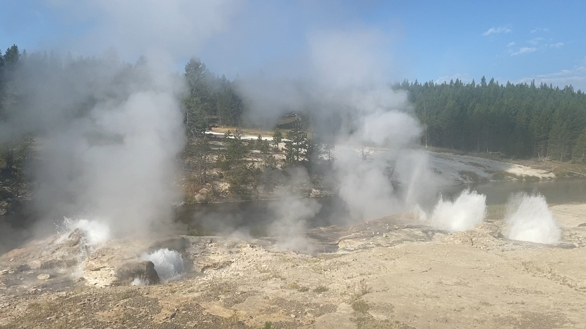
The wind and conditions for an eruption were ideal-- Warm enough that there was little steam, wind blowing downstream and away from the walkway, sun high enough in the east for rainbows. It also seemed like Lower Mortar was much more active than in the eruptions I've see over the past few years. All of the vents seemed to be taller or throw farther.
Afterwards, at Grand, it was a Turban Delay interval followed by five more intervals before we finally got the One Burst Grand. We never did find out when the overnight eruption occurred.
The next One Burst Grand Eruption took place just before sunset. Too bad there wasn't a second burst instead of one burst lasting 11-1/2 minutes. Also, this was another case where the eruption was preceded by a Turban eruption where Grand had little to no overflow.