
Posted on
Posted on
Posted on
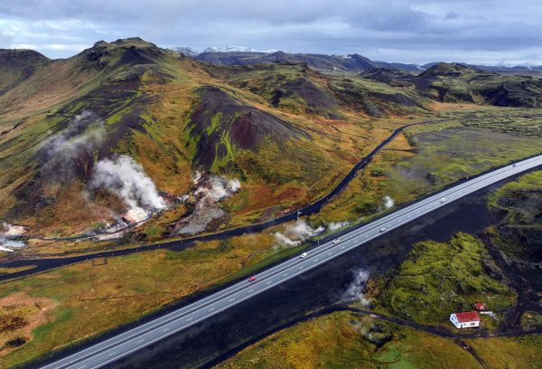
Changes at Hveradalir, Iceland.
Passing along an online report on changes at the Hveradalir geothermal area in Iceland that were posted at Iceland Monitor site.
Increased visible steam has been observed along the national highway through Hveradalir.
Geophysicist Ari Trausti Guðmundsson says that steam vents often form at relatively shallow depths in areas of geothermal activity and near hot springs.
“The best example is in Hverahlíð, south of the road leading up to Hellisheiði, where drilling was carried out for the Hellisheiði Power Plant. Suddenly, steam began rising from the hillside somewhat farther east,” he says.
Photos: Steam rising from the ground near the Ring Road
Back in August 2024 there was a landslide in the same area that exposed some buried features.
The landslide that took down material from the southeast side of Skíðaskálinn in Hveradalir in mid-July has probably broken the top layer of the soil above a steaming hot spring.
It is most likely that the combination of steam activity and high precipitation caused the landslide to occur at this time.
Photos: The landslide appears to have exposed a steam geyser
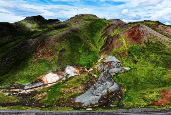
The main thermal area has a walkway and is easily accessible from the highway. We stopped in there when we visited in 2023. I remember a report from back then about steam appearing along the highway, visible in a traffic webcam view, but can't find that report now. So this activity may not be that new.
Posted on
Kilauea Eruption, Episode 34, 2025 October 01
The wait, despite the shorter expected interval, was longer this time. It started with the first visible pooling of the lava on the webcam at 2000. We continued to watch until we saw overflow at around 2145. Decided it was time to head over and start observing in person.
Arrived shortly before 2300, and did not witness another overflow until 0215. There was another almost two hours later. it was fairly strong, and lasted around 11 minutes.
The intervals were about one hour apart until 0700, with longer durations, when they started to decrease. By 1530, they had dropped into the 6 to 8 minutes range. This was starting to look the preliminary activity before the previous eruption.
All of these overflows seemed to have the effect of slowing raising the lip and bottom of the lava waterfall, with the bottom rising faster. There seemed to be less distance between the two by the time of the eruption start.
This state of affairs continued until 2100, when I decided to head back to the parking area and do some watching via webcam, which actually had a better view of the vent when it came to details.
The lot was full, but there was some turnover. A lot of the vehicles were running their engines, i guess because it was humid and foggy, and if you didn't open the windows, it fogged up inside.
The overflows stopped by the time I got to the car, and after several hours of absolutely nothing happening, Suzanne also returned and we went back to our accommodations to eat, recharge dead batteries and get a little sleep.
it was now well into 30 September, which was supposed to be our last full day of the trip. We had the webcam on the wall screen the whole time, and nothing continued to happen until noon approached. By then we decided to return to the parking lot to secure a space, if any were available.
We wasted some time since the overflows were still intermittent. The parking lot had a number of empty spaces when we arrived, but these were slowly filling up. The people started using the parallel spaces, and we decided it was time to return to the overlook.
We managed to replace our previous view spot, as there weren't many there. I didn't notice anyone who looked like they were waiting like we were, as we had the only chairs out there.
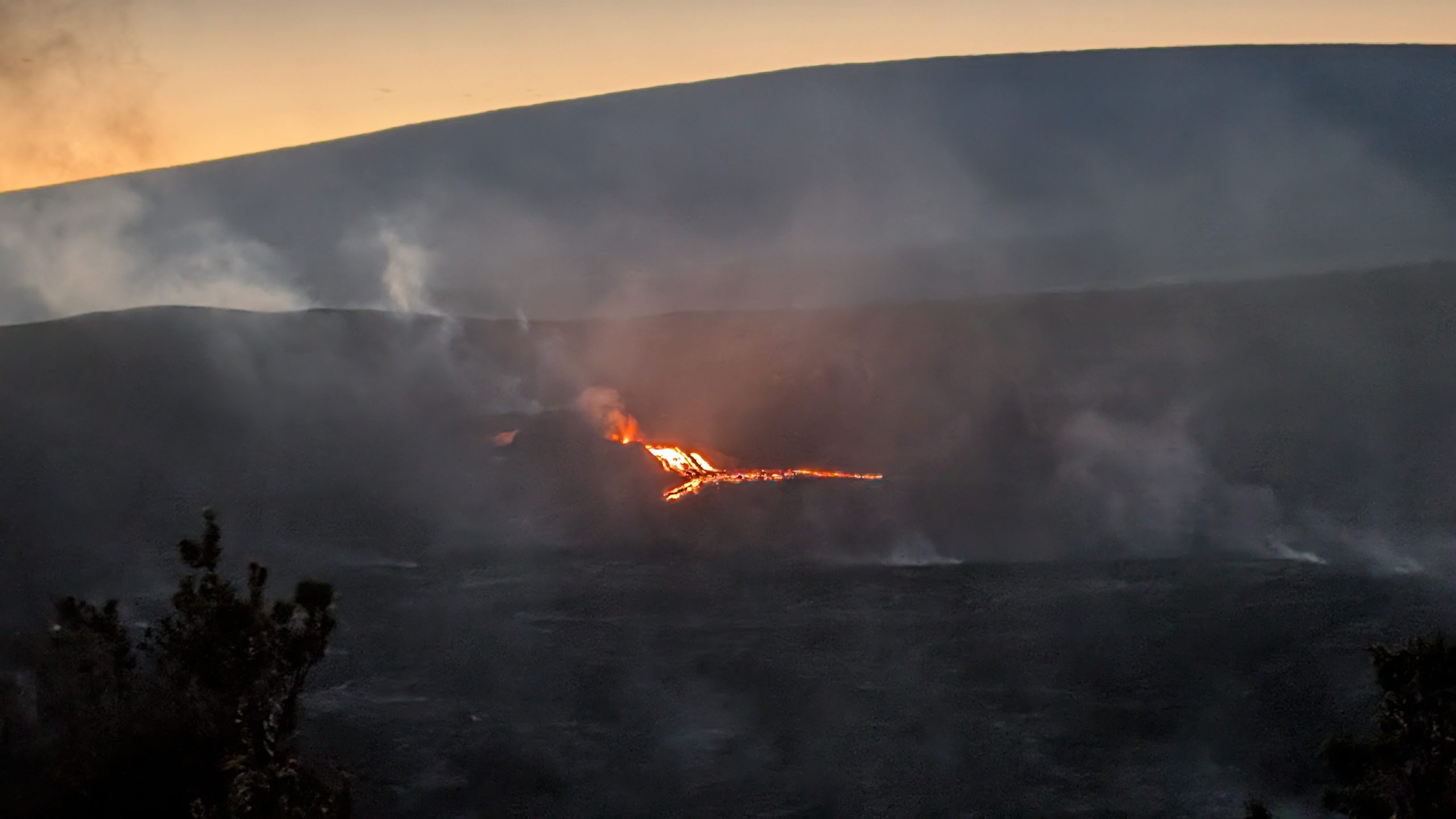
The second round of overflow ended around 1900. A couple of hours later I did as the night before, headed back to the car to reconfigure. Dozed off and just before midnight decided to check the camera again. There was heavy overflow from the vent, so called Suzanne to find out when it started. She said she was about to call me. I quickly got myself together, and a half hour later was back out. The sky was glowing red for the last half of the mile walk.
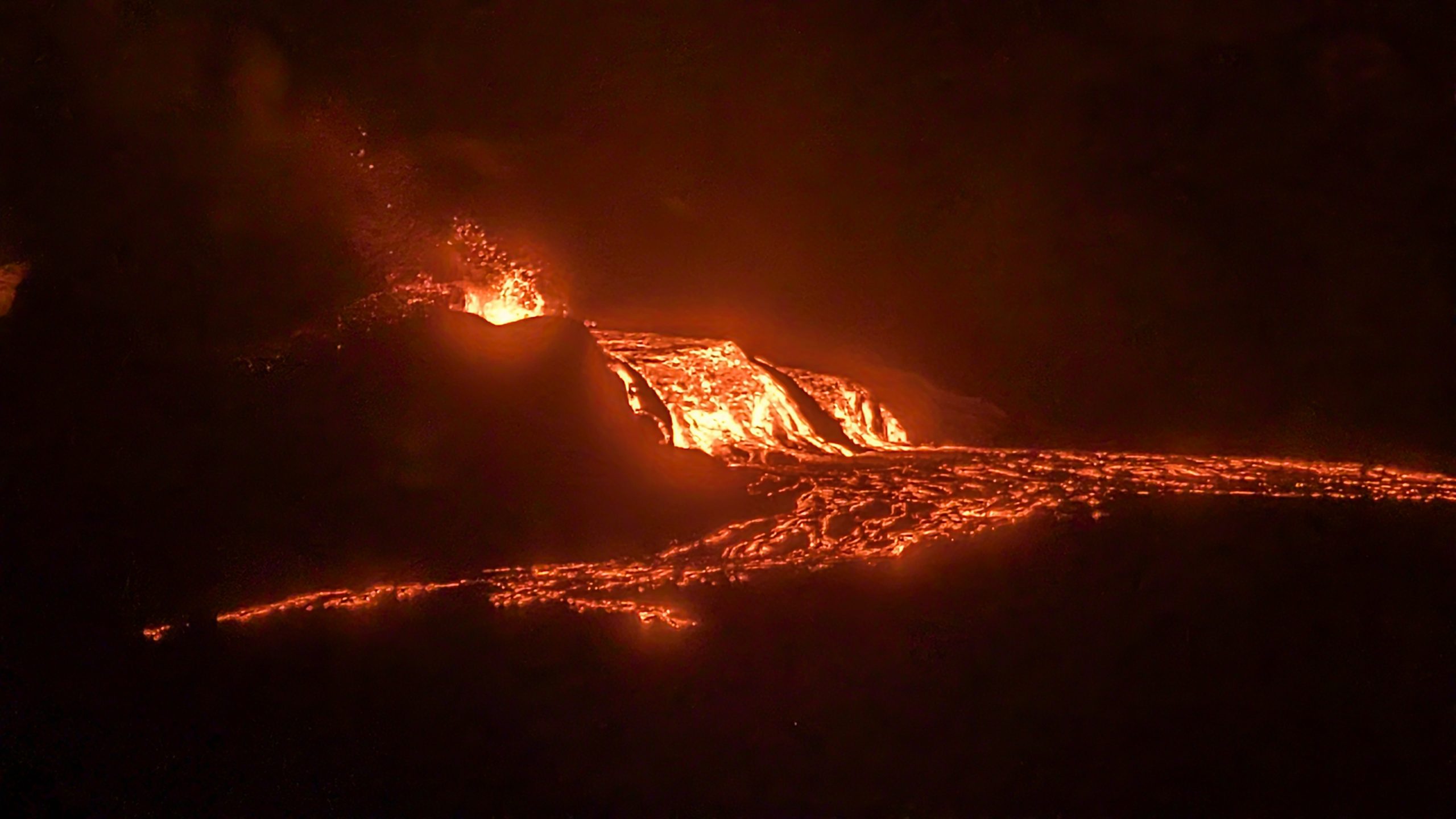
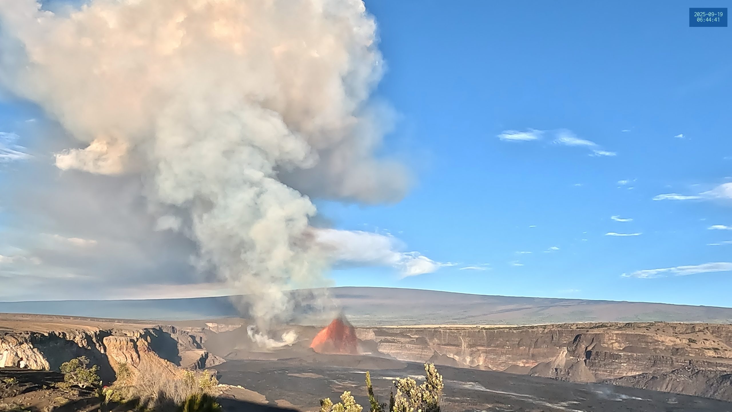
For the next half hour the flow did not let up, and then it seemed like the doming over the vent was turning to jetting. The USGS start of the eruption was put at 0053. For the next hour the height of the jetting got taller, surpassing the height we had seen in the previous eruption. Then at just before 0145, the glow in the South vent began to get brighter. First lava poured out, then it too began jetting. Within a couple of minutes its height was greater than that of the North Vent. And it continued to get higher.
At their best, I was estimating 240 to 300 m/800 to 1000 ft for the North Vent, and 350 to 450m/1200 to 1500 ft for the South. I've not seen a report for the North, but the USGS put the south at 1300ft, so my estimates were in range.
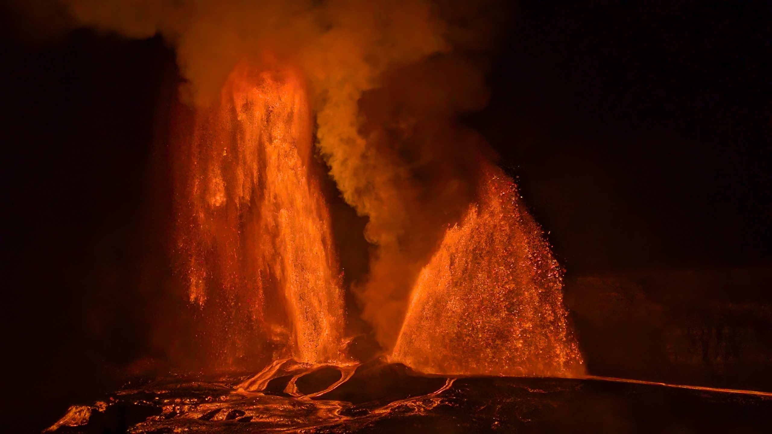
With the eruptions so tall, there was little liquid lava running down the slopes. Instead there was a stead rain of solidified lava. At times the jets were obscured by a curtain of this material. We could also see it being swept upwards by the convection current, which made height estimation a bit difficult.
With two lava columns, we could feel a bit of warmth coming from that direction, surprising considering the distance.
It wasn't until about 0400 that it started to look like the height was decreasing. Around 0530 I thought that the power of the columns was decreasing, but they kept coming back.
By then it was getting light. The night started out clear, but as it got lighter, the clouds turned to mist. It never turned into rain, but the area got wet.
Finally, around 0650 it be came obvious that the end was near. The South vent height dropped rapidly, ending at 0700. The North Vent continued for another three minutes before it also quit.
For the first few hours the crowd was well behaved. Around 0300 the Asian selfie mobs started to appear. At one point the took over a huge area beyond the rope boundary to the left of us, and proceeded for the next hour to prance around making idiotic poses and gang gestures. It got kind of tiring to see these same gestures over and over by people who seemed to be under the impression they were being witty and original. At a couple of points we had to yell at some of the selfie gaijin, as they were stop waving their overly bright lights in our direction, or getting too close to the cliff edge slope. I came to the conclusion that the best way to describe these people is that "they were not here to see the volcano erupt, but to be seen at the volcano eruption". It would have been easier and cheaper, in both time and money, so do their antics in front of a large screen projector. (I hope and expect to see so-called AI created selfies in the near future. Then maybe the selfie plague will end when no one will believe you were there.)
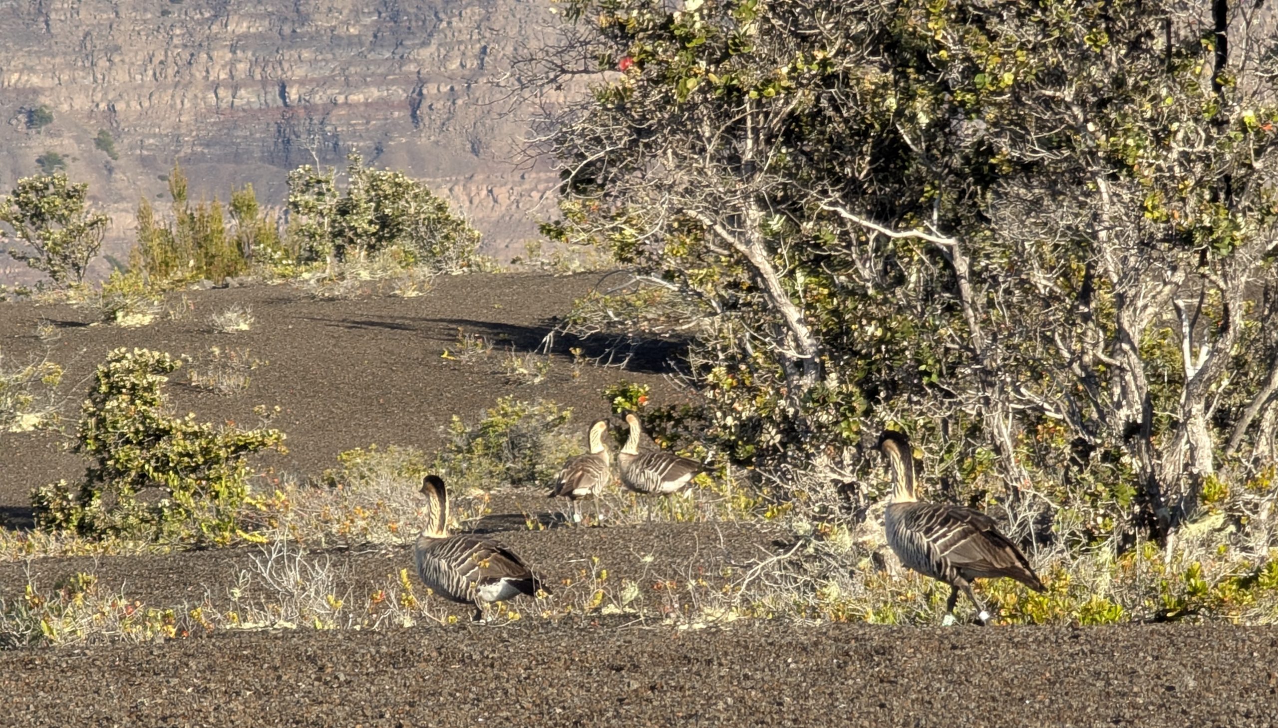
Just before the eruption ended, at dawn, a flock of nene (Hawaiian geese) flew behind us. As in Yellowstone, it appears they commute into an area in the morning, hang around for the day, then disappear at sunset. We saw them (with multiple tourists getting too close) on our way back to the parking lot.
The order of events we saw were quite similar in both eruptions we saw, but more drawn out this time, despite the shorter interval. At times it seemed the volcano was deliberately going slow to make sure we could not make our original travel plans for home. As it was, the eruption started after our deadline for leaving. Fortunately, we had alternate flights booked, and were easily able to extend the car rental. It was midday after the eruption ended when we were able to find a place to stay.
On the evening of 02 October, I felt the 3.7 earthquake at 2029 located just south of Pahala. It was like the rumbling for a second of a piece of heavy equipment (electric generator, for example) starting up. Outside, the frog noises, which are loud and constant much of the night, decreased for a moment or two. Suzanne didn't feel a thing.
Posted on
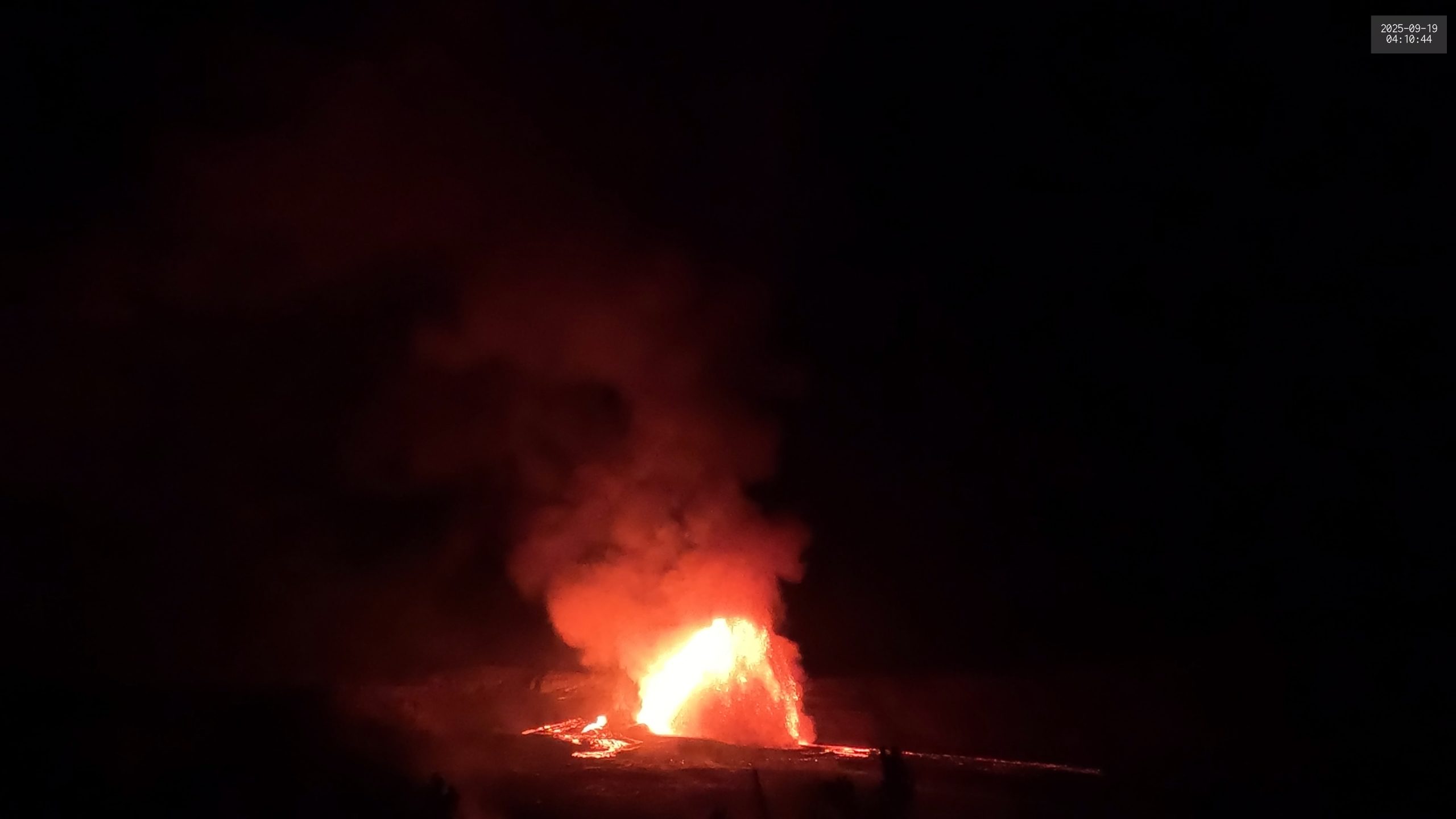
Kilauea Eruption, Episode 33, 2025 September 19
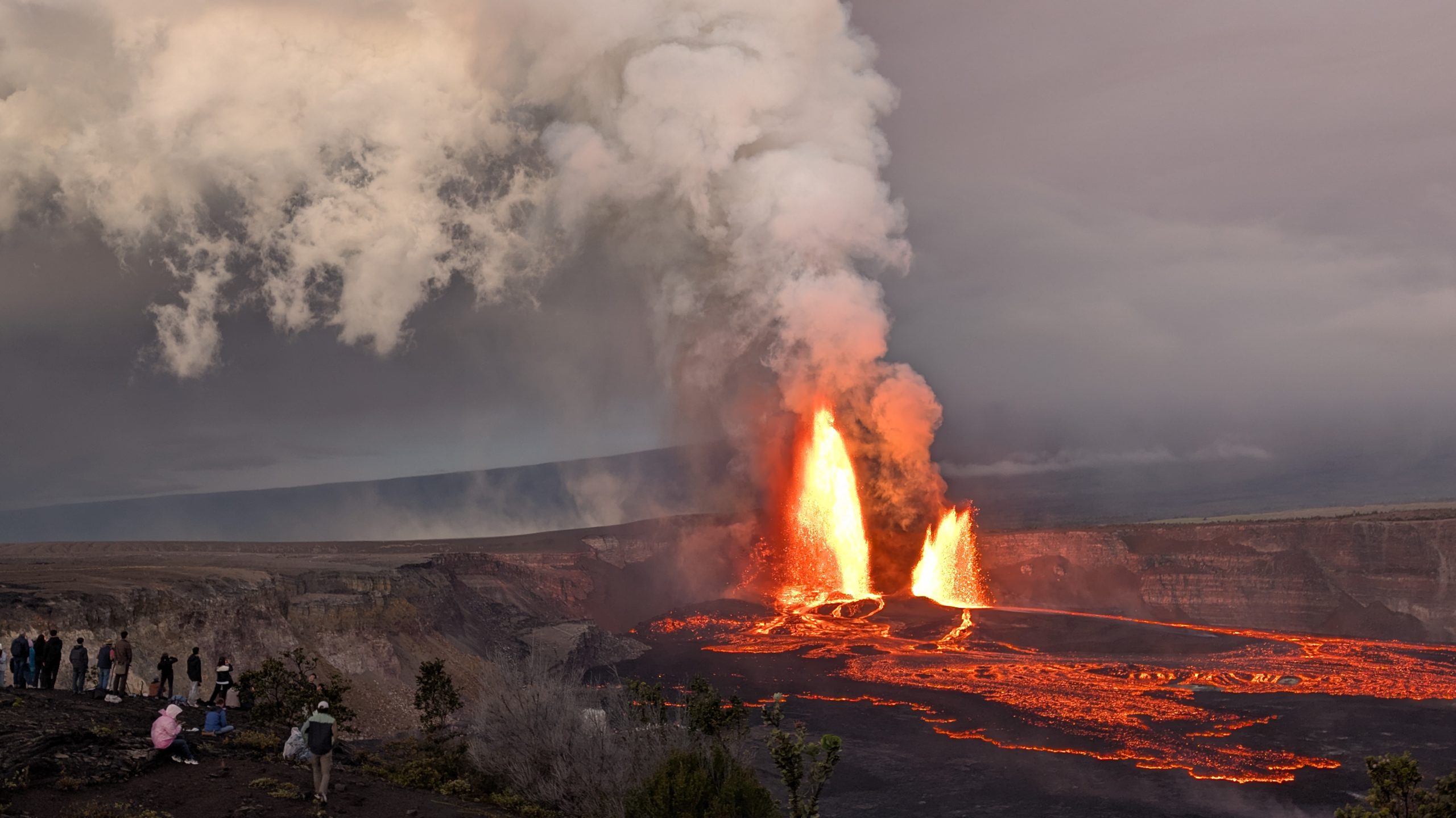
Since the last visit in December, what can be seen of the volcano has changes, as the level inside the crater has come up considerably, and the vents are now at the top of a large cinder cone. Spent a couple of days checking out the various viewpoints to determine which one best suited our needs. The viewpoint off the old Crater Rim Road before from the Keanakako'i Crater still seemed the best, although just down the road across from the crater seemed possible.
Across from the Kilauea Military Camp along the rim, between the trees, were a number of viewpoints with direct views at the vents, but these would view an inclined eruption column head on. It was from one of these at around 0838 on the morning of 17 September that we saw the first lava overflow for the upcoming eruption episode. Saw two from there, indicating that it was time to start paying attention.
We arrived around midnight to start 18 September. We decided to try the farther overlook, to stay away from the crowds at the main overlook. We had the area to ourselves, and started watching the overflows. The overflows were quite consistent, lasting about two minutes and occurring every seven to nine minutes. This location was a bit breezy, and during much of the night until dawn it was damp from a consistent mist that never really turned into rain.
Around noon the overflows stopped. We returned to the car and the parking lot to get out of the wind for a while. A couple of overflows around 1400 got us back out, but these overflows again stopped, with nothing going on until sunset. We decided to go back to the car to get a nap and wait for something to happen. By 2100, nothing had, se that was when we decided that we needed to return to our cabin to rest up, have something to eat, and recharge our various powered devices. Put the V1 webcam view on the wall screen and waited.
Around midnight (again) we saw the first lava overflow since sunset, and knew it was time to head out. The parking lot was half empty, which was a pleasant surprise. We had thought that there would be a considerable number of people waiting. Decided that were we had waited the day before was too windy and exposed, and would need to join the rest of the crowd. We left our cabin at 0100, arrived at the parking lot 15 minutes later, and walked out to the main overlook, arriving around 00:45. The overflow had continued, or restarted before we arrived. (The glow was consistent on the walk out.) We found the rope line pretty much filled with people waiting. Found a spot that gave us an unobstructed view, and started another wait.
This time the overflows were more irregular and longer. A couple of hours later we got the strongest one yet, and it looked as if it was finally going to go into a full eruption. The USGS start time was 0311, but from our point of view it had started well before that.
Unlike a geyser, where the maximum height is near the start. This eruption took its time, at least a half hour, to slowly reach full height. For this eruption, that height seemed around 225m/750ft, and it stayed there for several hours.
Several times during this period, starting at 0400, the South Vent started to overflow, then well up strongly for a minute or two. It looked like it too was about to start erupting, but it never did. By dawn this activity had subsided.
Before dawn there was an influx of people who seemed to only be there to take selfies, no matter what the volcano was doing, so they got lucky to see an eruption. By sunrise most of the people waiting overnight had left.
Just before noon the South Vent overflowed again, the first time in daylight. With the second overflow, it seemed apparent that the eruption was ending. Over a matter of a couple of minutes the North Vent eruption height dropped, and then it quit.
People applauding the end of an eruption is not just a Yellowstone Grand Geyser phenomena. That happened with the end of this eruption.
There seemed to be a large contingent of people arriving just after the eruption ended. Overheard a few mentioning that they were staying at resorts in the Kona area, which is well over two hours drive away. So I would suspect these are people who hadn't intended to be hear, but in the morning heard of the eruption and headed over, leaving at the start of Tourist Hours (1000-1700), arriving just in time to miss everything.
Posted on
GeyserLog 4.1.1
GeyserLog 4.1.1 is available on the iOS AppStore.
Added SMS note support and fixed a few bugs found during field testing:
- Fixed issue where edited changes could be lost in the event submission view.
- Fixed crash in GrandWait summarizing Turban events.
Once again, geyser gazers are welcome to contact me to get a Promo Code which will allow downloading of the app for free. I'm also open to suggestions for features users would like to see added, or finding out about bugs that need to be fixed.
Posted on
Yellowstone Radio — 2025
Haven't done this in a few years, but during the first visit back in May and June, there was enough strange calls that I decided to try it again this latest trip.
20 Aug
- At Lower Station, RV hits awning with roof air conditioning unit, left area, probably not aware of the damage.
- Motorcycle vandalism call at VC parking lot. Culprit was a raven.
- After sunset, but while still light, report of wrong way driver at exit to Firehole Canyon Drive.
21 Aug
- Person in SUV coming through the south entrance with smoking joint visible
- Two calls in 1/2 hour of wrong way travel on OF entrance roads.
- South of Fountain Flats Dr a gravel truck partially spilled a load, causing damage to several cars. One was undriveable due to windshield damage.
22 Aug
- At 0630, actual fire in Lodge employee kitchen
- C-Tour bus entering Midway parking lot going in left/wrong lane
- Someone very upset over her entrance station experience, including verbal abuse and throwing maps back. Got verbal warning for "discon" — disorderly conduct.
23 Aug
- Seven Romanians warned for thermal trespass at Midway.
24 Aug
- Replacing a dumpster at the VC that got hit and no longer opens.
- Gate runner— excuse was he was coming in to tow out "boss' truck" on trailer. Got a court date for failure to pay, and operating commercial vehicle. Escorted out when noticed he was attempting to do a U-turn and not leave.
26 Aug
- Cowbird with string wrapped around leg at OF boardwalk. Not sure what to do.
- In afternoon, tent set up at turnout just west of Madison Campground.
28 Aug
- Rear end collision at crosswalk next to ranger station results it two vehicles in need of towing.
- Visitor assist at Riverside. Woman at the Dan Wenk Memorial Vault needs assistance as she has dropped her iPhone into the pit. (They are supposed to be water-resistant…) Phone was retrieved and successfully recovered.
29 Aug
- Vehicle in VC parking lot "being attacked by raven."
- In looking for the assault ravens, encountered littering. Contact had two prior IMARS in recent years: Assault, and dog off leash and obstructing traffic.
- Porcupine carcass removed from road near Biscuit Basin.
31 Aug
- "Discon"-- woman trying to "save a spot" in lot beside Lodge was nudged twice by a car wanting that spot real bad.
- Responding ranger commenting on previous entry, "looks like mid-July out here."
- Updates to earlier nudging report: Soon after the initial calls from the parking lot, the comm center was able to determine that the driver had reservations at Fishing Bridge. Driver was later contacted and given a verbal warning for disorderly conduct.
01 Sep
- Morning call about messy, post-party Madison campsite. Mostly empty cartons and containers, no actual food. Verbal warning, but leaving today.
- Trash container at Lone Star trailhead is overflowing.
- A long one-- report of erratic driving for a car heading north from Old Faithful, including near head on collisions. LE quickly catch up north of Fairy Falls and witness similar behavior. Turns out the driver has suspended driver's licenses from both Wyoming and Montana and has a outstanding warrant for immigration violations. Two people in the car, and neither person can speak English. Companion has no identification. Driver gets a trip to Mammoth. The companion claims to be a juvenile, and they have problems trying to figure what to do with him. They tried to call what was supposed to be a family member in Bozeman, and got a hangup.
- At Madison campsite, occupants have dug a large hole that is a tripping hazard.
- Also at Madison. Someone reporting that their hatchet and two boxes of wood are missing from their campsite.
04 Sep
- Report of woman lying down between parked cars in the lot behind the Lodge. When contacted, ran off into the woods toward the cabins. Later found near the Rec Hall behind the Lodge. Arrested for intoxication. Also looking for a Prius with expired registration, maybe possible breakup with driver of car.
- Because of this previous incident, "no one available right now" was the response to "thermal trespass" at Giantess.
- Someone in VC giving Old Faithful information/prediction on NPS West Direction channel. Gets the Comm Center response: "Unit on Direct. You are not on Common."
05 Sep
- Raccoon inside vehicle parked behind Inn. It appears to be a pet.
06 Sep
- At Midway — citation for parking in gov't reserved parking space.
07 Sep
- In East Lot — ravens looting the back of a pickup truck.
08 Sep
- Written warnings to at least four vehicles in the "make your own parking space" line between Lower Ham's and the Gas Station. One of them also had plates which expired on 29 Feb 2024.
- Madison Campground host calls for attitude adjustment at particular campsite. Warning issued for off-road vehicle and for food storage.
- After sunset, escorting a wide load from OF to West Yellowstone.
Posted on
Observations for 2025 September 10
A moonlight Beehive eruption in the early morning, except the moon was hidden by some clouds. Along with the lights from the Inn, there was still enough to see it, so that it didn't need to be lit up.
While passing by Sulphide on the way back we caught a smell I've never encountered in this area before, that of a skunk. Didn't notice it on the way out, and was localized to just that area.
A few hours later, in the time it took to go into the Lodge and check out from our cabin, two ravens managed to open the pocket on my bike handlebars and empty the contents out onto the pavement.
Posted on
Observations for 2025 September 09
By getting out at the eight hour mark, only ended up waiting for Grand for an hour. It was cold and clear, so the moon was bright. The One Burst Grand eruption was short enough that it could've had a second burst, but the slowing down during the final minute seemed like an indication that once it ended, Grand wasn't going to restart.
2025-Sep-09 : 03:16:04 T1C

 03:16:00	Turban	-0m04s
 03:16:04	B1	--- d=08m54s
 03:18:25	Vent	2m20s
 03:24:59	P1	8m54s
Vent & Turban continue

				     	ΣD=08m54s
	* * * * *
 02:33:28			d=03m46s
 02:52:33	Int: 19m05s	d=03m33s
		     Turban: 23m27s
Beehive erupted just before the start of the Grand eruption window, so many were able to see both eruptions. Ended up waiting for about 1-1/2 hours before the start of a West Triplet eruption, then we needed to wait until West Triplet was nearing the end of its eruption before we got another One Burst Grand eruption.
This eruption had a definite false pause around the nine minute mark before its sudden resumption of activity for another 1-1/3 minutes. West Triplet quit at about the same time as Grand, and Rift still hasn't made an appearance in several days.
2025-Sep-09 : 12:24:12 T1C

 12:23:13	Turban	-0m59s
 12:23:33	Vent Ovfl	-0m39s
 12:24:06	Boop	-0m06s
 12:24:12	B1	--- d=10m19s
 12:26:44	Vent	2m32s
 12:33:11	FP	8m59s
 12:34:31	P1	10m19s
Vent & Turban continue

				     	ΣD=10m19s
	* * * * *
 10:38:42			d=04m02s
 10:55:56	Int: 17m14s	d=03m38s
 11:14:29	Int: 18m33s	d=03m19s
 11:31:11	Int: 16m42s	d=03m35s
 11:48:37	Int: 17m26s	d=03m41s
 11:58:16	West Triplet
 12:06:00	Int: 17m23s	d=03m37s
		     Turban: 17m13s
It was after sunset, but still light, as I headed out for the next Grand eruption. As I approached the signboards and junction by the lift station, I noticed three deer right next to the bike trail. One ran across the trail into the trees, while the other two stared at me for a few moments, then went bounding off into the meadow toward Old Faithful and Geyser Hill.
I had just tied down my bike at the bikerack near Castle, and was walking toward Crested Pool when Castle started to erupt. It being a windy day, I quickly went the rest of the way toward Tilt to watch what turned out to be the second major eruption of the day. By that time I'd already seen that Rift was in eruption.
Rift erupted for another hour. Two Turban eruption intervals after Rift had quit, Turban had a strong, but short eruption. The next interval was short, and there was little overflow from Grand. So it wasn't a total surprise when the next Turban eruption started strongly. Others waiting for Grand were illuminating it, and I could see at least one boop before the One Burst Grand eruption started. Once again, we got an eruption lasting less than ten minutes with no attempt at a second burst.
2025-Sep-09 : 21:35:42 T1C

 21:35:24	Turban	-0m18s
 21:35:37	Boop	-0m05s
 21:35:42	B1	--- d=09m30s
 21:38:19	Vent	2m37s
 21:45:12	P1	9m30s
Vent & Turban continue

				     	ΣD=09m30s
	* * * * *
 20:04:06			d=03m14s
 20:22:18	Int: 18m12s	d=03m22s
 20:41:44	Int: 19m26s	d=03m59s
 20:59:36	Int: 17m52s	d=02m58s
 21:16:38	Int: 17m02s	d=03m06s
		     Turban: 18m46s
Posted on
Observations for 2025 September 08
The Beehive's Indicator call came in about an hour before the time the alarm was set. It was hours before dawn, so nicely backlit by the almost full moon.
Took a short nap, then went out for a 2-1/2 hour wait for a One Burst Grand Eruption. At first it was dark and mostly clear, with the moon a couple of hours from setting. As it got lighter, the fog formed so that by the time Grand finally did erupt, it was not possible to see into the Sawmill Group from the trees by Rift. Uncertain erupted, and I couldn't tell that until I got closer.
2025-Sep-08 : 07:26:05 T1Q

 07:25:48	Turban	-0m17s
 07:25:58	Vent Ovfl	-0m07s
 07:26:05	B1	--- d=11m15s
 07:28:40	Vent	2m35s
 07:37:20	P1	11m15s
 07:38:26	V&T Quit	12m21s

				     	ΣD=11m15s
	* * * * *
 05:03:08			d=04m47s
 05:20:43	Int: 17m35s	d=03m51s
 05:38:39	Int: 17m56s	d=03m47s
 05:57:45	Int: 19m06s	d=03m45s
 06:15:11	Int: 17m26s	d=03m19s
 06:33:11	Int: 18m00s	d=03m51s
 06:51:13	Int: 18m02s	d=03m43s
 07:09:22	Int: 18m09s	d=03m28s
		     Turban: 16m26s
A bit later headed out with the intention of waiting for Oblong. The large steamcloud I saw while riding past the Lodge said that we were a bit late. So instead went Fan & Mortar to see what it wasn't doing.
As I arrived, Bottom was erupting, and Fan's High and Gold vents had high water levels and were erupting vigorously. That activity died down, and over the next couple of hours, there were a series of more ordinary cycles which were never really strong.
Just as about to leave came a radio call about some interesting activity by East Sentinel. The boiling was quite strong, and cyclic. Every fifteen to twenty minutes, the right side would increase in activity and pour water over the side nearest to us. Occasionally the left side would show some activity, but only briefly. It looks like East Sentinel needs to be watched for an eruption.
By then it was time to return to Grand. On the way back, Rocket had a major eruption start just as I rode up. Shortly after, the guy dumping boardwalk pieces fired up his powered wheelbarrow, providing an unwelcome amount of noise. Rather than put up with it, I left.
Arrived at the Grand Group with West Triplet in eruption. Grand spent the next two hours never trying to erupt. Then we got a Turban Delay interval, and four more Turban eruption intervals later Grand finally appeared ready to erupt.
It was a slow start with almost a minute between the start of Turban and the start of Grand. It was a pleasant surprise when the first burst ended at 7m20s. I had just been joking about how we never seemed to get short first bursts any more.
The pause was pretty normal, and Grand didn't play around too much prior to the second burst. That burst wasn't long, and after it quit, it seemed like Grand was sloshing more than normal, with jets of water coming from the vent, when suddenly the pool drained. The eruption lasted less than nine minutes. West Triplet started just before the second burst started.
2025-Sep-08 : 18:12:32 D4/T2C

 18:11:40	Turban	-0m52s
 18:11:43	Vent Ovfl	-0m49s
 18:12:27	Boop	-0m05s
 18:12:32	B1	--- d=07m20s
 18:14:49	Vent	2m17s
 18:19:52	P1	7m20s d=39s
 18:20:31	B2	7m59s d=46s
 18:21:17	P2	8m45s
Vent & Turban continue

				     ΣB=08m06s	ΣD=08m45s
	* * * * *
 14:59:15	West Triplet
 15:00:27			d=03m04s
 15:19:21	Int: 18m54s	d=03m38s
 15:37:40	Int: 18m19s	d=03m34s
 15:56:59	Int: 19m19s	d=03m28s
 16:15:47	Int: 18m48s	d=03m29s
 16:34:01	Int: 18m14s	d=03m26s
 17:03:31	Int: 29m30s	d=04m53s  D0
 17:20:42	Int: 17m11s	d=03m13s  D1
 17:36:49	Int: 16m07s	d=03m41s  D2
 17:54:40	Int: 17m51s	d=03m50s  D3
 18:20:26	West Triplet
		     Turban: 17m00s
Even with the short eruption duration, Grand didn't seem to have any afterplay.
Did not stick around for the end of West Triplet, or a start of Rift as it was pointed out that this was an ideal time for an eruption of Great Fountain. So left quickly, and when we got over to the cabin to load up the bikes, learned that overflow had started about a half hour prior. So we had plenty of time to drive out and bike over.
The sun was about to set, and it was below the horizon when Great Fountain finally did erupt. But it was still well lit, and after a few preliminary surges, we got a huge burst that sent out multiple waves across the terrace. Not a superburst, but still impressive, and it all showed up nicely in the recording I made. Didn't stick around much longer, as no one wanted to deal with biking back in the dark.
On the drive back, I did get to encounter just over the Biscuit Basin bridge an oncoming van that just had to get in front of someone else even though I was coming right at him. At least I didn't have to deal with any bison on the road.
In the cabin area, the elk continue to bugle off in the distance to the south.
Posted on
Observations for 2025 September 07
The moon was nearly full, but the sky and view seemed off, thanks to the considerable smoke still in the air. Shadows were faint and indistinct, and filled in from light scatter by the smoke.
With Grand having erupted during Rift the previous evening, it was hoped that this next Grand eruption interval would be shorter than average. Instead, several Turban eruption intervals after arrival there was a longer Turban interval. It wasn't long enough to be considered a formal Delay, but it felt much like one. Afterwards, the next Turban eruption was accompanied by no runoff from Grand, also typical of a Delay type eruption.
During the wait, I kept checking the weather radar map, because there was a small patch of showers that first appeared over Jackson Lake, and was slowly moving north. Every time I looked, it seemed like it was about an hour away.
So it took Grand five Turban eruption intervals to finally have its One Burst Eruption.. Turban started well before Grand. By that time the clouds had started to move in, so the moonlight, combined with steam from the water column in windless conditions, made viewing difficult. No chance for moonbows.
2025-Sep-07 : 03:19:29 T1Q

 03:18:59	Turban	-0m30s
 03:19:29	B1	--- d=10m59s
 03:21:58	Vent	2m29s
 03:30:28	P1	10m59s
 03:31:27	V&T Quit	11m58s

				     	ΣD=10m59s
	* * * * *
 00:52:59			d=03m52s
 01:12:37	Int: 19m38s	d=03m54s
 01:35:13	Int: 22m36s	d=03m39s
 01:51:46	Int: 16m33s	d=03m40s
 02:10:41	Int: 18m55s	d=03m51s
 02:27:54	Int: 17m13s	d=03m43s
 02:45:20	Int: 17m26s	d=03m37s
 03:02:53	Int: 17m33s	d=03m34s
		     Turban: 16m06s
Some point after we returned to the cabin, the showers finally came through, as everything was wet when awakened by the call that Beehive's Indicator was erupting. Didn't have enough time to make it out of the cabin area before the Beehive eruption started.
Thanks to the longer intervals, Grand was finally going to have an eruption wait starting at a new time of day. West Triplet was in eruption, quitting without a Rift eruption. As it ended, Grand had a long Turban Delay interval. Three Turban eruptions later, we got another long wait as the pool slowly filled, but never started pulsations until the last minute.
Even after Turban started, it seemed Grand was reluctant to erupt. The Vent overflow was well after Turban started, and then Grand had at least 15 seconds of Boops before finally erupting. The first burst lasted well under nine minutes, and there was a short pause. Then the second burst lasted almost two minutes. After the eruption, it took Vent & Turban, which quit, about twenty minutes to restart.
2025-Sep-07 : 11:54:32 D3/D0/T2*Q

 11:53:50	Turban	-0m42s
 11:54:06	Vent Ovfl	-0m26s
 11:54:16	Boop	-0m16s
 11:54:32	B1	--- d=08m44s
 11:56:59	Vent	2m27s
 12:03:16	P1	8m44s d=22s
 12:03:38	B2	9m06s d=01m58s
 12:05:36	P2	11m04s
 12:06:21	V&T Quit	11m49s
 12:28:00	V&T Restart	33m28s

				     ΣB=10m42s	ΣD=11m04s
	* * * * *
 10:07:51ie	West Triplet
 10:12:44			d=03m38s
 10:46:30	Int: 33m46s	d=05m20s  D0
 11:04:52	Int: 18m22s	d=03m52s  D1
 11:22:06	Int: 17m14s	d=03m37s  D2
		     Turban: 31m44s
Went out for Grand's first overflow, which was relatively short at 4h17m. Once again, this took place during an eruption of West Triplet and a Turban Delay interval.
Made it back to the cabin just ahead of the first thunderstorm. The second one featured raisin sized hail that turned the area white, along with at least one lightning strike nearby, as I saw now flash but heard what sounded like a gunshot.
The rains continued up to the time to head back out for the next Grand eruption, and I decided I'd rather not get wet for a One Burst Eruption, or even a two burst eruption.
Posted on
Observations for 2025 September 06
With intervals averaging around eight hours, Grand has locked itself into erupting around the same time of day, every day. Right now that means just before dawn, middle of the day, and just after dark. This morning, I was fully dressed and about to head out the door when I saw that the webcam was reporting Grand in eruption. So time to undress and get a couple more hours of sleep.
Went over to Geyser Hill to try and get some video recordings. Did get another eruption of Slot, and could have gotten a Lion initial if I had been paying attention. With the huge crowd forming after the start of Beehive's Indicator, I decided to try and do a video from Sponge. With the smokey haze creating a white background for the white eruption column, it's probably not the greatest.
Early afternoon it was time again for the mid-day Grand eruption. Which turned into the late afternoon Grand eruption.
I got out to the Grand Group with West Triplet in eruption. When that ended without an eruption of Rift, I figured we had a bit of a wait until the next West Triplet eruption. That took place over three hours later, after a long series of quick fills by Grand, followed by low pool waves and short Turban eruption intervals and durations.
During the wait we also got to see a Castle minor eruption and three Daisy eruptions.
West Triplet finally erupted again, with no real change in Grand's behavior. Finally Rift started to erupt, and then we got the One Burst Grand eruption another two Turban eruptions after that. The eruption lasted almost exactly ten minutes, but at least Vent & Turban continued.
2025-Sep-06 : 17:36:45 T1C

 17:36:09	Vent Ovfl	-0m36s
 17:36:12	Turban	-0m33s
 17:36:37	Boop	-0m08s
 17:36:45	B1	--- d=10m01s
 17:38:52	Vent	2m07s
 17:46:46	P1	10m01s
Vent & Turban continue

				     	ΣD=10m01s
	* * * * *
 13:03:02
 13:19:53	Int: 16m51s	d=03m53s
 13:36:22	Int: 16m29s	d=03m27s
 13:53:59	Int: 17m37s	d=03m36s
 14:12:21	Int: 18m22s	d=03m35s
 14:30:08	Int: 17m47s	d=03m13s
 14:47:34	Int: 17m26s	d=03m37s
 15:04:50	Int: 17m16s	d=03m24s
 15:21:37	Int: 16m47s	d=03m06s
 15:38:00	Int: 16m23s	d=03m04s
 15:55:49	Int: 17m49s	d=03m31s
 16:11:10	Int: 15m21s	d=02m54s
 16:14:23	West Triplet d=01h00m
 16:28:18	Int: 17m08s	d=03m09s
 16:45:08	Int: 16m50s	d=03m01s
 16:55:31	Rift
 17:02:56	Int: 17m48s	d=02m42s
 17:20:03	Int: 17m07s	d=03m30s
		     Turban: 16m09s
Posted on
Observations for 2025 September 05
The string of One Burst Grand eruptions continued today.
First it was the one before dawn, which consisted of a series of short Turban eruption intervals before a short One Burst Grand eruption.
2025-Sep-05 : 05:47:55 T1C

 05:47:04	Turban	-0m51s
 05:47:55	B1	--- d=09m26s
 05:50:17	Vent	2m22s
 05:57:21	P1	9m26s
Vent & Turban continue

				     	ΣD=09m26s
	* * * * *
 03:44:40
 04:01:42	Int: 17m02s	d=03m49s
 04:20:59	Int: 19m17s	d=03m20s
 04:38:37	Int: 17m38s	d=03m35s
 04:56:05	Int: 17m28s	d=03m09s
 05:12:07	Int: 16m02s	d=02m58s
 05:29:16	Int: 17m09s	d=03m34s
		     Turban: 17m48s
Then there was the One Burst Grand eruption that had a shorter series, but also had short Turban eruption intervals. This time Turban initiated the eruption, and it lasted over 11-1/2 minutes. West Triplet also started erupting just over a minute after Grand started. And once again, there was some large afterplay from Grand starting about five minutes after the restart. Disappointed that we didn't get the Rift eruption over with.
2025-Sep-05 : 14:02:22 G1Q

 14:02:17	Boop	-0m05s
 14:02:22	B1	--- d=11m35s
 14:02:26	Vent Ovfl	0m04s
 14:02:43	Turban	0m21s
 14:05:28	Vent	3m06s
 14:13:57	P1	11m35s
 14:14:39	V&T Quit	12m17s
 14:22:07	V&T Restart	19m45s

				     	ΣD=11m35s
	* * * * *
 12:54:50
 13:08:50	Int: 14m00s	d=04m25s
 13:27:33	Int: 18m43s	d=03m37s
 13:45:14	Int: 17m41s	d=03m58s
 14:03:32	West Triplet d=35m33s
		      Grand: 17m08s
Just after dinner came the call for Beehive. During the walk over, also heard that Depression was starting to erupt, so I managed to capture that to video.
At the seven hour mark, Rift was in eruption, and had been so for quite a while. Only 45 minutes into the wait, Castle started to erupt, and it quickly became obvious that it was going to be a major eruption. A number of those waiting were going to go over there to look for moonbows, with Rift still in eruption. But on the next Turban eruption opportunity, it also became obvious that Grand was going to start, based on the strong Turban eruption.
There was a nice, short first burst, a fairly lot pause, and a short second burst. It was dead calm, and the jets of water rose above the building steam cloud. But once again, we got a two burst eruption lasting less than ten minutes, with Vent & Turban then quitting.
2025-Sep-05 : 22:13:24 T2Q

 22:12:40	Turban	-0m44s
 22:13:24	B1	--- d=08m15s
 22:15:53	Vent	2m29s
 22:21:39	P1	8m15s d=45s
 22:22:24	B2	9m00s d=33s
 22:22:57	P2	9m33s
 22:24:08	V&T Quit	10m44s

				     ΣB=08m48s	ΣD=09m33s
	* * * * *
 21:17:05			d=03m46s
 21:36:51	Int: 19m46s	d=03m35s
 21:55:05	Int: 18m14s	d=03m26s
		     Turban: 17m35s
Castle was still in eruption, and had pretty much made the transition to steam, but was still impressive seen from the boardwalk, and there was enough spray to see a nice moonbow.
Posted on
Observations for 2025 September 04
Another morning wait for Grand with the previous eruption time in doubt. But only a 1-1/2 hour wait before the One Burst Grand eruption, and did get to see from Sawmill the Beehive eruption. The start of Grand's eruption was one of those where the pool is nice and high early, and never drops or does something annoying.
2025-Sep-04 : 09:44:26 G1Q

 09:44:23	Boop	-0m03s
 09:44:26	B1	--- d=10m46s
 09:45:03	Turban	0m37s
 09:46:15	Vent Ovfl	1m49s
 09:47:36	Vent	3m10s
 09:55:12	P1	10m46s
 09:56:09	V&T Quit	11m43s
 10:03:28	V&T Restart	19m02s

				     	ΣD=10m46s
	* * * * *
 08:29:52			d=03m25s
 08:48:30	Int: 18m38s	d=03m44s
 09:08:34	Int: 20m04s	d=03m20s
 09:26:31	Int: 17m57s	d=03m35s
 09:53:57	West Triplet d=33m35s
		      Grand: 17m55s
West Triplet started at about the time it became apparant that this was going to be a long eruption. I waited for the end of that eruption intending to record the start of Rift's eruption, but for once I was disappointed that Rift did not erupt.
Afterwards realized that it had been an hour since the last report of an eruption of Tilt, so waited about ten minutes to record the next eruption. At least I didn't wait an hour there like the last attempt.
Went out to Grand prepared for a stay into the dark, and needed what I took out. First, West Triplet was in eruption as I arrived, and when it ended without a Grand or Rift eruption, I figured we had a few hour wait until the next West Triplet eruption.
During the wait, Grand had several early fills but then dropped. West Triplet finally erupted over three hours later, and the very next Turban eruption was a Delay eruption interval. Then 45 minutes later Rift started. Fortunately, Grand was able to have the One Burst Eruption two Turban eruption intervals later. The moon was brown, so the view wasn't great.
2025-Sep-04 : 21:13:05 D3/G1C

 21:13:05	B1	--- d=09m33s
 21:13:51	Turban	0m46s
 21:15:58	Vent	2m53s
 21:22:38	P1	9m33s
Vent & Turban continue

				     	ΣD=09m33s
	* * * * *
 17:02:19			d=03m02s
 17:20:44	Int: 18m25s	d=03m10s
 17:39:54	Int: 19m10s	d=03m16s
 17:58:25	Int: 18m31s	d=03m22s
 18:15:25	Int: 17m00s	d=03m12s
 18:33:00	Int: 17m35s	d=03m25s
 18:53:43	Int: 20m43s	d=03m56s
 19:14:36	Int: 20m53s	d=03m57s
 19:32:50	Int: 18m14s	d=04m07s
 19:50:27	Int: 17m37s	d=03m59s
 19:57:58	West Triplet d=44m30s
 20:22:28	Int: 32m01s	d=04m38s  D0
 20:38:33	Int: 16m05s	 D1
 20:40:05	Rift
 20:54:25	Int: 15m52s	d=03m09s  D2
		      Grand: 18m40s
It was pointed out that the missing GeyserTimes Grand info could be because it was never entered in the first place. That would seem to be the case, as there are a few non-electronic records during those years. But the electronic times never duplicate the observed times. That implies that the electronic records are incomplete. In any case, I are confused, and maybe what is going on with the electronic records needs to be clarified.
Posted on
Observations for 2025 September 03
After last night, not in a great hurry to get out and about. Did end up getting out to Grand Group around the seven hour mark. An hour later it was warmer and drying and we got a nice One Burst Grand. No West Triplet eruption before or after.
2025-Sep-03 : 10:08:32 T1Q

 10:08:17	Vent Ovfl	-0m15s
 10:08:20	Turban	-0m12s
 10:08:25	Boop	-0m07s
 10:08:32	B1	--- d=10m09s
 10:11:06	Vent	2m34s
 10:18:41	P1	10m09s
 10:20:01	V&T Quit	11m29s

				     	ΣD=10m09s
	* * * * *
 08:56:20			d=03m14s
 09:15:40	Int: 19m20s	d=02m56s
 09:34:19	Int: 18m39s	d=03m13s
 09:51:09	Int: 16m50s	d=03m33s
		     Turban: 17m11s
In the Sawmill Group Uncertain was splashing and slopping out water, so it wasn't a long wait before we got an eruption there. Did not seem to be as tall as the one I saw yesterday from Grand.
Oblong hadn't been seen this morning, so worth a trip down that way. Economic was in slight overflow, although it is getting oranger. Got to Oblong, and barely had enough time to set up the camera before the eruption began.
About that time came a call that water was splashing in Fan's Main Vent. Got down there and there were still a number of huge splashes seen. Mortar's Bottom vent was also in eruption when Gold and High vent had abrupt starts. High was especially impressive, and if later in the cycle, would have been a really good sign. Instead the activity slowly decreased. But it is encouraging that Fan & Mortar are exhibiting more than short, weak cycles.
From there, it was noted that it had been over a day since an eruption of Artemisia had been seen. A quick side trip showed that East Sentinel was boiling heavily, but there was no sign of any recent eruption. At Artemisia there was first a short wait before an Atomizer minor eruption, then almost immediately Artemisia started. The wind was ideal the entire eruption, with the steam going into the trees and no one having to move to avoid the steam bath.
On the way back, attempted to see a Rocket Major eruption, but instead got Grotto quitting. The dumpster makes for a nice view block for a number of the benches which by then were in the shade.
Just got back to the cabin after having a burger at the Lower Store when suddenly Beehive's Indicator started. So it was back out to Geyser Hill. Little Squirt may have started erupting during Beehive's eruption, because I don't remember seeing it when walking out, and the water was just starting to progress down one runoff channel.
Got out to Grand in time for a Castle minor eruption. Then waited an hour for West Triplet to start. This time Grand had the One Burst Eruption on the next Turban eruption. It was short in height, but long in duration.
2025-Sep-03 : 18:20:01 T1Q

 18:19:18	Turban	-0m43s
 18:19:22	Vent Ovfl	-0m39s
 18:20:01	B1	--- d=11m47s
 18:22:25	Vent	2m24s
 18:31:48	P1	11m47s
 18:32:39	V&T Quit	12m38s
 18:39:14	V&T Restart	19m13s

				     	ΣD=11m47s
	* * * * *
 17:26:45			d=03m44s
 17:44:57	Int: 18m12s	d=03m35s
 18:02:55	Int: 17m58s	d=03m41s
 18:05:12	West Triplet d=36m29s
		     Turban: 16m23s
Since the wait for Grand was shorter than expected, some of us went down to Oblong to see if we could catch another eruption. Waited until well after sunset, but despite some strong overflows, it did not erupt.
Posted on
Observations for 2025 September 02
In the predawn hour, just outside my cabin, I encountered a deer as I was headed toward the indoor plumbing. It was still there, but took off, as I returned.
Went out to check on Grand next, and found that it had erupted as I was getting prepared to go out. I did see a steamy runoff channel from Rift, indicating that it had quit during or just after the Grand eruption.
Back to the cabin, where it was time to make a quick sandwich for breakfast. Just as I put the jelly on the bread, get a radio call for Beehive's Indicator in eruption. The sun was low and it was calm, with a nice rainbow at the top of the water column and in the rainfall.
It was during Beehive's eruption that another radio call came through. This time it Fan & Mortar were finally having an observed event cycle, with Main Vent splashing and Bottom Vent erupting. So after returning to the cabin, got on the bike and headed on down. Nothing much came of it, but it's nice to see something happening there.
The afternoon eruption was really a wait for West Triplet to erupt. The Turban eruption intervals were fairly short, and it wasn't until West Triplet erupted that Grand showed that it might erupt, by having the Turban intervals get shorter. The One Burst Grand eruption took place on the Turban eruption immediately after the end of the West Triplet eruption. The start was nearly simultaneous, with Grand having a boop, then Turban, then the Grand start, all within a couple of seconds. The eruption itself was long, almost 12-1/2 minutes long.
2025-Sep-02 : 15:03:09 T1Q

 15:02:53	Vent Ovfl	-0m16s
 15:03:08	Turban	-0m01s
 15:03:09	B1	--- d=12m26s
 15:05:46	Vent	2m37s
 15:15:35	P1	12m26s
 15:15:54	V&T Quit	12m45s
 15:24:18	V&T Restart	21m09s

				     	ΣD=12m26s
	* * * * *
 12:59:16
 13:16:27	Int: 17m11s	d=03m53s
 13:34:52	Int: 18m25s	d=03m45s
 13:52:31	Int: 17m39s	d=04m02s
 14:11:06	Int: 18m35s	d=03m46s
 14:18:35	West Triplet d=34m25s
 14:28:57	Int: 17m51s	d=03m28s
 14:47:05	Int: 18m08s	d=03m01s
		     Turban: 16m03s
Back out to Grand in the dark, but with a nice moon until well after midnight. An hour after arrival West Triplet started, triggering Rift to start just before midnight. Waited a few more Turban eruption intervals, then as the moon was setting, decided to give up and head in.
Had just approached the bike rack at Castle when we heard the radio call for Beehive's Indicator. So bicycled back to the cabin and headed for Geyser Hill. The moon had set, so the bright lights were on. I was at Anemone when it started. Was quite impressive.
Returning from Geyser Hill we saw a large steamcloud to the north. Grand was erupting.
Back at the cabin, headed to the indoor plumbing and in the light from the streelight I saw a head poking up from behind the rocks along the drive. Was being watched by a deer just downslope from the road. Leaving the restrooms I was surprised by a second deer running out from the cabin area, across the road and running down the hillside. The first deer on the slope was still there, watching me. Then it moved away and I lost sight of it.
Posted on
Observations for 2025 September 01
I want to get a video of Tilt from the start, as part of my project to document all sorts of features. The best way to get a full eruption of any geyser is to start recording well before there's any indication of an eruption. So I spent an hour out there, with nothing happening. Finally Tilt starts to steam heavily and splashing begins. And that's when the battery finally runs out. I had checked just a minute or so before, and it still read 10%, so that last tenth goes quickly. Noted for the future. And I still need a full Tilt eruption.
After that fiasco, it was time to head to Grand. Not sure if Rift erupted overnight. It was two hours of non-descript Turban eruptions, again. Grand then finally looked good around the 20 minute mark, and kept on slowly filling and started to have waves. This process was so slow that Grand ended up having a Turban Delay for the One Burst Eruption. It lasted just under ten minutes, just before the end West Triplet began erupting.
2025-Sep-01 : 12:34:36 D0/G1C

 12:34:32	Vent Ovfl	-0m04s
 12:34:36	B1	--- d=09m49s
 12:34:39	Turban	0m03s
 12:37:01	Vent	2m25s
 12:44:25	P1	9m49s
Vent & Turban continue

				     	ΣD=09m49s
	* * * * *
 10:35:39
 10:51:59	Int: 16m20s	d=03m31s
 11:10:36	Int: 18m37s	d=03m59s
 11:29:11	Int: 18m35s	d=03m55s
 11:48:13	Int: 19m02s	d=03m57s
 12:05:48	Int: 17m35s	d=03m24s
 12:43:06	West Triplet d=36m03s
		      Grand: 28m48s
Beehive's Indicator was called just as Grand started. The bench behind me, which had been full, was empty by the time Vent started.
After Grand I stuck around to get the duration on West Triplet, to see if Rift would start, and also to observe if there was afterplay. There wasn't any afterplay other than a few weak splashes just about the time West Triplet ended, a half hour later. Rift did not erupt.
Back out at sunset for another West Triplet eruption. And once again, no Rift eruption. I thought that would be a good sign, but instead ended up waiting almost three hours before getting the One Burst Grand eruption. And West Triplet was not erupting when finally left the area.
2025-Sep-01 : 22:28:39 T1C

 22:28:28	Turban	-0m11s
 22:28:39	B1	--- d=09m35s
 22:31:20	Vent	2m41s
 22:38:14	P1	9m35s
Vent & Turban continue

				     	ΣD=09m35s
	* * * * *
 19:39:16ie	West Triplet d>=19m09s
 19:48:14			d=03m51s
 20:04:56	Int: 16m42s	d=03m29s
 20:23:29	Int: 18m33s	d=03m55s
 20:43:41	Int: 20m12s	d=03m51s
 21:01:53	Int: 18m12s	d=03m46s
 21:20:11	Int: 18m18s	d=03m38s
 21:38:50	Int: 18m39s	d=03m16s
 21:55:24	Int: 16m34s	d=03m07s
 22:12:02	Int: 16m38s	d=03m18s
		     Turban: 16m26s
During the wait Castle had another minor eruption.
So this afternoon, shortly after Rift failed to give me its blessing, as I'm leaving the area, I notice a host of GeyserTimes note entries for several features in the Sawmill group, each with cutesy commentary. The last one for Spasmodic is one word: "Chunked".
I have no idea what this is supposed to mean, and I've been observing the Sawmill Group for decades. So I post a flag on the entry, "what does "chunk" signify?" Is it supposed to be a noun, verb, adjective, or some other meaning?
The poster, "Craigmon99", instead of clarifying the observation, amends the comment to say, "Chunk! The feature that is known as Chunk near Spasmodic was overflowing HKoenig… are you familiar? :)"
It seems "Chunk" is what was years ago called Spasmodic's Triangle Vent. For years it had a small rock wedged into it, and no attempt was made at removal because the most likely outcome would have pushed it deeper. It disappeared one year. It was also one of the vents that was vandalized when someone went around dumping purple dye into some features in May 2020.
In any case, the owners of GeyserTimes don't like "interpersonal drama", so this insult has been swept into the Memory Hole. I want to preserve it here. And it was an insult, as too many newcomers are treating GeyserTimes as their personal High School Cafeteria where Kool Kidz hang out and insult the nerds and geeks.
Related, I've also learned recently that for a number of years all the Grand observations: codes, durations and comments, etc., have been deleted in favor of electronic download records. I checked, and that's the case from 1999 through 2001.