Posted on

Observations for 2026 March 03


Today was the day to visit Waiotapu. As usual, we arrived as early as possible. The objective was to quickly assess the situation at the Waiotapu Geyser (#70) and then based on those observations, either wait or go watch the Lady Knox spectacle.

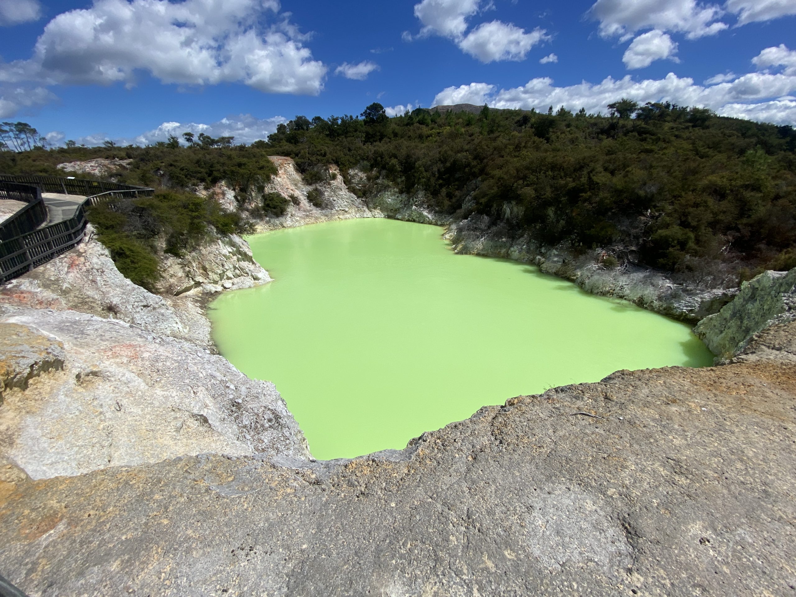
The first thing noticed was that the water level in Rotokarikitea/Devil's Cave appeared to be down at least a meter, based on the yellowish bathtub ring above the current water line. When the sun came out, the water was the brilliant greenish, almost phosphorescent color we'd seen during previous visits.

Rotokarikitea/Devil's Cave at Waiotapu.

When we got to the geyser, it was pretty obvious that it had not erupted recently. The formations surrounding the vent were completely dry, despite it being a cold, humid morning. The vent was mostly in shadow, but there was no indication of any water visible in the vent. Twenty minutes later, everything appeared to be the same, so we decided to join the crowd headed to see the induced eruption.

There was a long line of cars headed that way, and we learned that it was possible to pay for admission at the gate there. I don't remember that being the case when we went there in 2019. In any case, that would not have altered our plans. We found some open seating down at the front, in what at the time appeared to be a location that wasn't down-wind.

The stadium was packed, more so than our previous visit, which was still pretty full. Previously, there had been a small talk about the history, the soap was introduced and once the geyser started to overfoam the guide let it be the center of attention. The eruption we saw lasted well over a half hour, and was still erupting as we left.

Crowd at Lady Knox

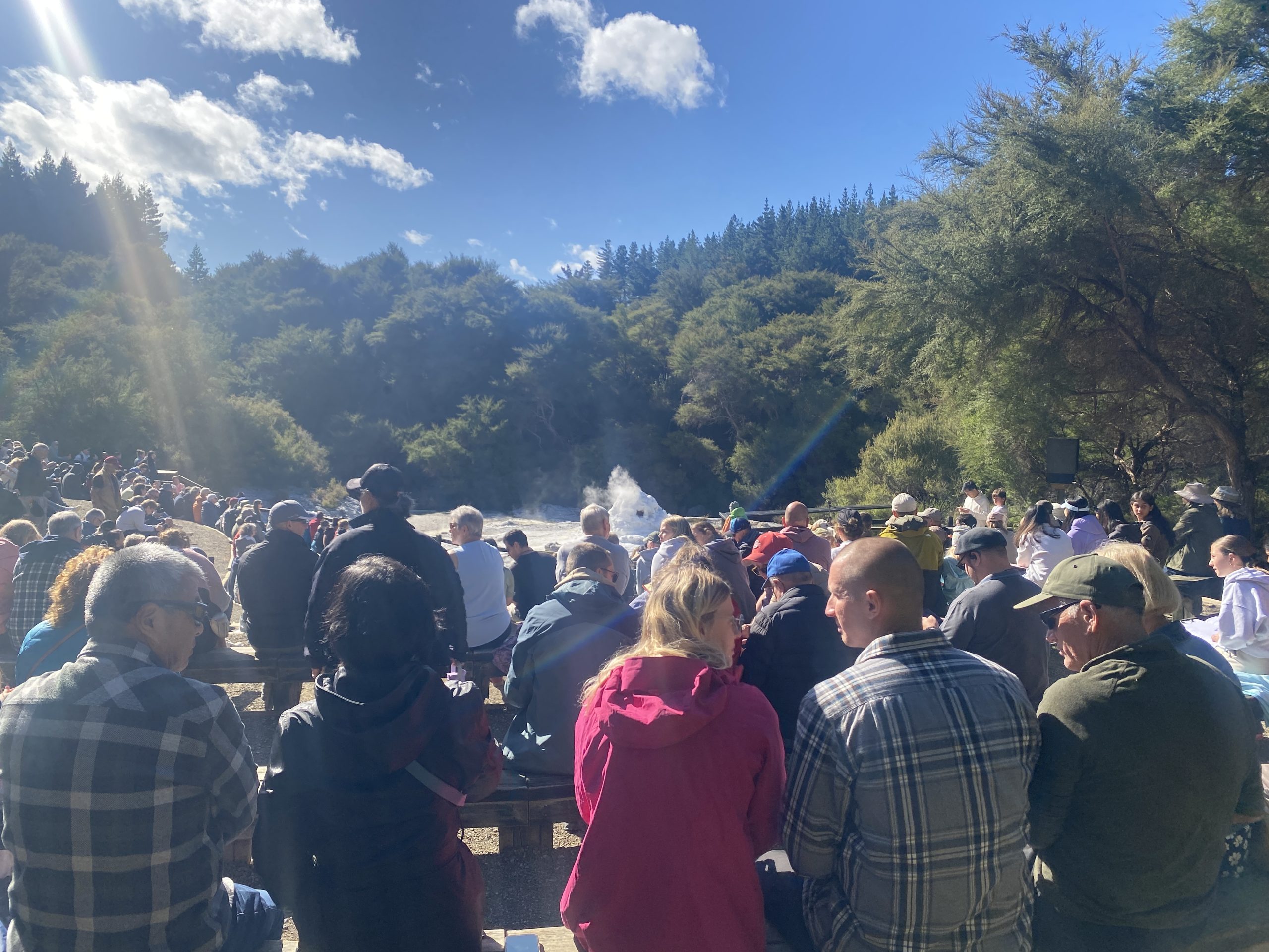
This time there was entertainment. The guide sang a Maori song as the overfoaming started, so when the eruption started, we couldn't hear it, despite some roaring as it reached maximum height. Then the eruption died down completely, ending at just over a minute in duration. There was no attempt at any afterplay splashing that I could see. On the whole, a disappointing experience. Years ago we managed to induce better eruptions from #42w.

We returned to the main thermal area a pretty much the end of the line of vehicles, but we did get a decent parking spot. Returned to the geyser overlook, and learned that we hadn't missed anything. The area around the vent was still dry, and even with the better sun angle, there didn't appear to be any water visible in the vent.

Also while we were gone, it got windy at the overlook location, which made observing distinctly uncomfortable. Suzanne left me to do that. Just a short distance away there were some picnic table in the sunlight where the breeze was tolerable, so I waited there for ten to fifteen minutes, then returned to the overlook to be disappointed by no change in the geyser.

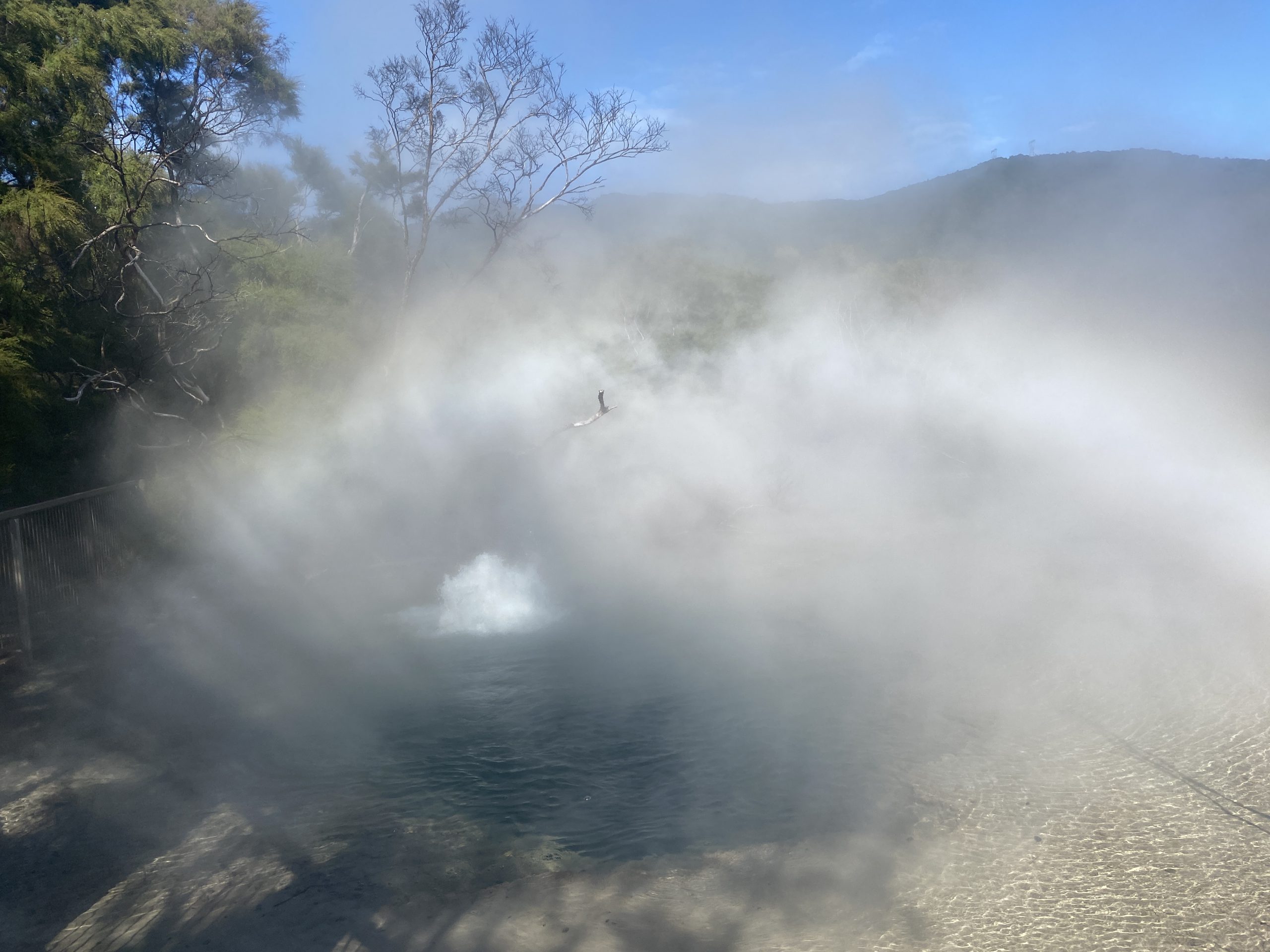
Finally gave up a couple of hours later. Figured that there wasn't going to be enough time for the geyser to show signs of life before closing time. Did do some videos of Champagne Pool and the features around it. There was one vent that was splashing slightly, which was the sum total of the natural eruption activity I saw today.

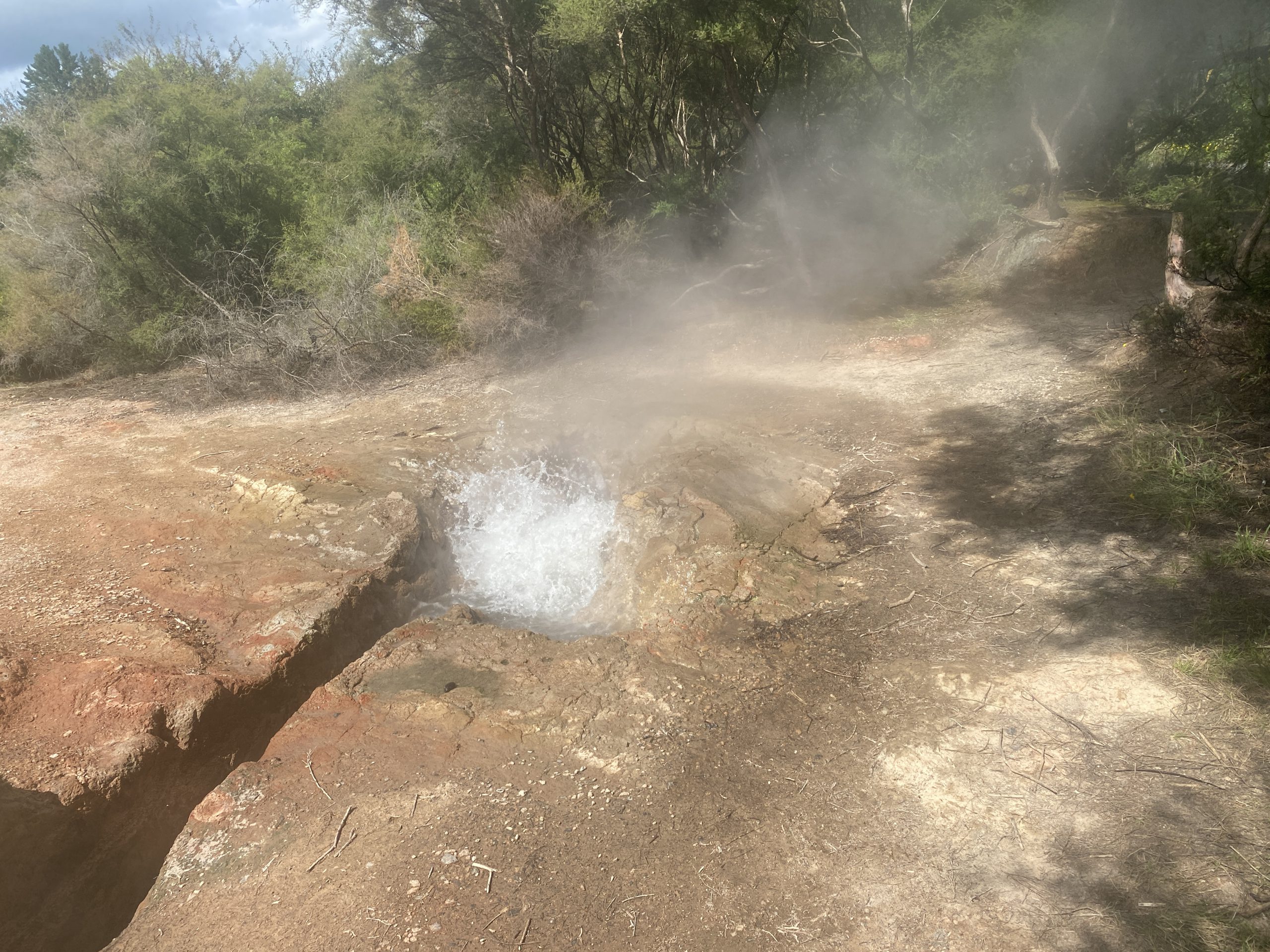
Since it was just down the road, we stopped in at the mudpots again. The activity there was much more entertaining. There were a couple of areas that every so often would explode with mud thrown in all directions, reaching heights of about four meters.

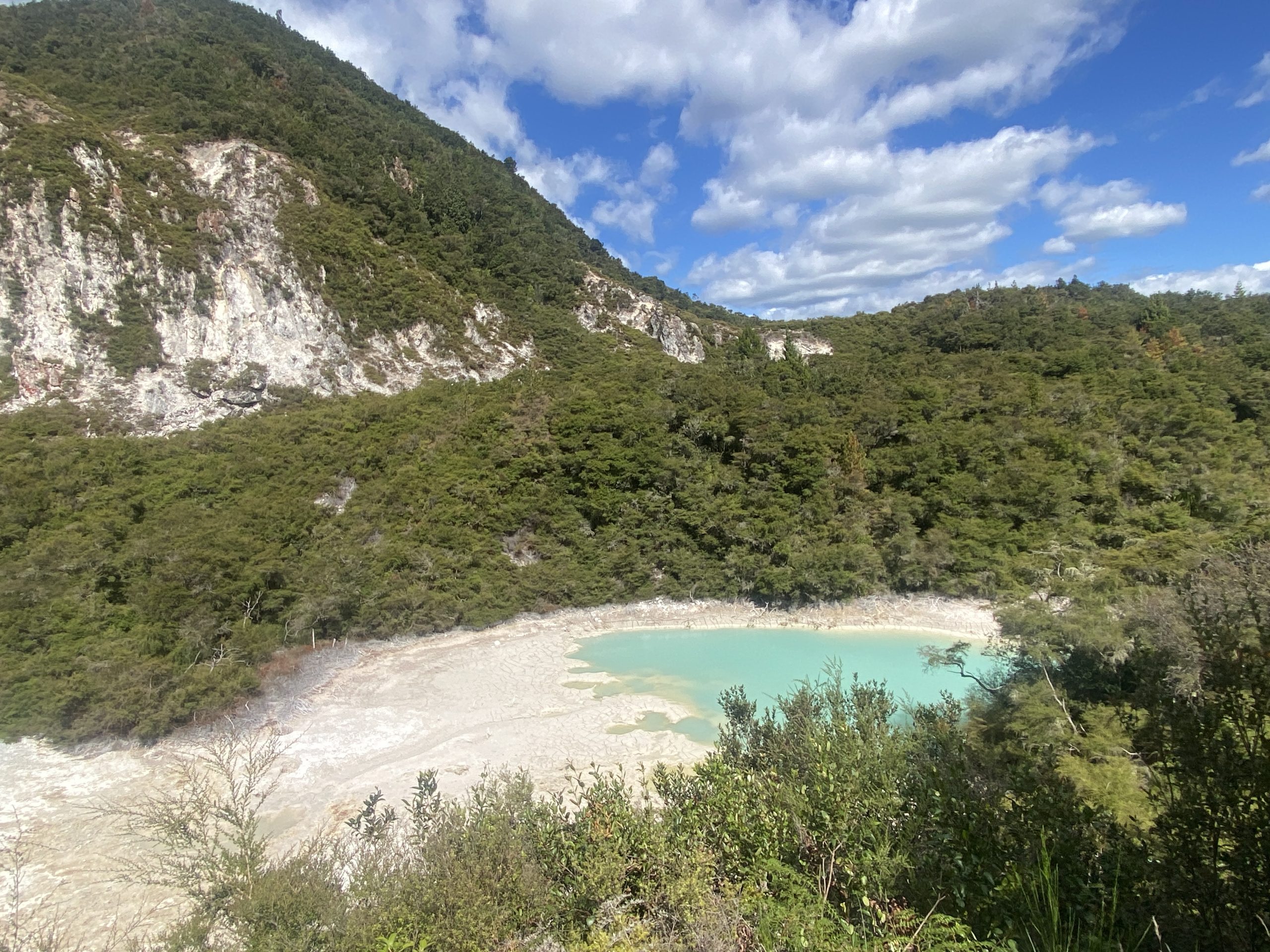
Finally, on the drive back, we stopped at the trail to the Crater Lake overlook. This is a warm thermal pool at the base of Rainbow Mountain. It used to be two craters, but the one to the north was more of a mud flat. The color of the water is that milky, opalescent blue that would otherwise indicate that it was much hotter.

Crater Lakes.

At this point I'm thinking that should there be a future visit to New Zealand, there will be no need to visit Waiotapu.


Posted on

Observations for 2023 March 04


It was cool and damp when we arrived at Tokaanu. Before going into the Reserve proper, we investigated the features across the road. There we could hear, hidden in the bush, the sounds of splashing. Along the street, there were areas of hot ground, including a spot between the curbstones where a frying pan was forming.

Went into the reserve, and almost immediately things didn't look good. There were two vehicles parked exactly at the spot where there's a gap in the fence to get to Taumatapuhipuhi. On the back of the flatbed truck was a dog that loudly objected my presence anywhere while I was within sight. It barked continuously for several minutes. At one point I heard an eruption hidden by the vehicles, which I assume was Taumatapuhipuhi. I finally decided to walk the loop taking videos and then decide what to do.

As I neared the finish of the loop, I heard the vehicles leave. The way to Taumatapuhipuhi was now open. As it turned out, I heard them leave as I was passing a feature that would become a center of attention during our visit, and so I didn't pay as much attention to that feature as I should have.

Eruption of Taumatapuhipuhi, 11:54

Was able to log the times for eight consecutive eruptions of Taumatapuhipuhi, starting with the one I heard. The intervals started long. We had to wait almost 36 minutes to see the eruption after the one I heard. From then on, the intervals decreased so that the last interval we saw was 21 minutes. Because of this, we did miss a couple of the eruptions. The first time that happened, we walked up to see the sinter platform wet and steaming. The second time I did get an "in eruption" time.

The durations of the eruptions varied from 26 to 10 seconds, with the other three durations being about 20 seconds. The heights were about two meters, and wide. I got splashed once standing about three meters from the rim.

The reason we missed eruptions was because we discovered another erupting feature. Named Hoani, it is a wide, deep boiling pool. The central pit was about five meters across, and I could not see any bottom to it. It is located in a broad, tannish colored sinter sheet depression.

Eruption of Hoani

When I walked by taking a video, and the video shows that it was quite hot, and full to the rim. I didn't remember any such feature from our visit four years ago. After the first eruption of Taumatapuhipuhi finished, we decided to head back to look at a few features along the trail, and immediately noticed the 30-40cm high boiling on one side of the crater. This boiling built up to well over a meter, then subsided. This activity continued for at least 1h15m, and we probably saw it near the start. At one point, I saw some surges that could have been two meters high. The activity was much like Artemisia.

The walkway was not built with an erupting, boiling spring in mind. There were times when I was walking along that the fog from the eruption was almost scaldingly hot. This steam was condensing on some of the trees, producing a rain below them. We tried to time our visits to Taumatapuhipuhi and spend rest of the time at Hoani, which is why we missed a couple of Taumatapuhipuhi eruptions.

It was after one of those eruptions that we noticed that the pool was quiet again. Previous pauses had lasted only a few seconds, but this one stretched into a minute or more. Then we noticed that the pool was dropping. By the time we left the area, 45 minutes later, Hoani was down 30-40cm, with the outer rim already drying in spots.

Beyond Taumatapuhipuhi is an area that's been heavily "culturally modified." An area of hot ground and frying pans that's been converted into an area for the preparation of hangi, the Maori method of cooking in hot ground.

Hangi area, Tokaanu.

After almost four hours at Tokaanu, we headed towards Rotorua. There were a couple of minor thermal areas north of Taupo that we had not visited the last time that we were going to try to see.

The first was "Craters of the Moon", where the Karapiti Blowhole was located. The area has been heavily affected by the nearby geothermal powerplants, and consists mostly of subsidence craters with some weak fumaroles scattered about. The only feature of any interest is the replacement for Karapiti, which is up on a hillside and consists of a wet, moderately noisy fumarole and some other noisy fumaroles. This of "A Fumarole" at Fountain Paint Pots.

This area can be bypassed unless you want to see what a destroyed thermal area looks like, or want to complete a checklist.

The second stop was going to be the "Wairakei Thermal Valley". This is an area that used to contain close to a hundred geysers, some playing to over 30 meters. It is now completely overgrown because all the activity has gone into making electric power. Was not looking forward to visiting, but figured should at least see what it looked like. But when we got to the entrance road, we were blocked by a closed sign. In the Taupo area the cyclone of a few weeks earlier had destroyed a significant percentage of the trees in the area. A lot of those trees had their tops snapped off, while others were complete uprooted.

(Earlier in the week, near Tongario National Park, we had to lengthen our hike to a waterfall by an extra 500 meters because the road was blocked in three places by downed trees. The road was low priority for clearance, as it had no other reason for being other than access to that hike.)

Since we had a little time, and we were passing right by, instead we stopped at the Waiotapu Mud Pots. These are in a free area, and well worth a stop. In the pool were a number of active areas spouting mud to as much as three meters high. These areas were periodic, with the longer the quiet period, the more vigorous the activity when it finally did erupt.