
Posted on
Category: New Zealand
Posted on
Posted on
Thermal Walk, Whakarewarewa Village, New Zealand
The names and labels used are based on several maps and sources, some of which disagree.
Posted on
Whakarewarewa Rāhui, New Zealand
Posted on
Rotorua Lakeshore and Government Gardens, New Zealand
Video by H.Koenig
Posted on
Tokaanu Thermal Reserve, New Zealand
Posted on
Champagne Pool, Waiotapu, New Zealand
Posted on
KiwiRail, South Island, New Zealand.
In Hokitika, on the South Island's West Coast, one branch of the New Zealand national railroad ends at a major dairy. There was a daily train going there the three nights we stayed there, coming in while dark in the morning, leaving in the late afternoon.
At Arthur's Pass is a passenger station at the line's summit, where westbound trains go into the Otira Tunnel. The tunnel is 8.5km long with a 3% downgrade , so there are helpers added and removed here. One freight train is a unit train carrying coal from west coast mines to a power plant near Christchurch. Not sure what the other is carrying.
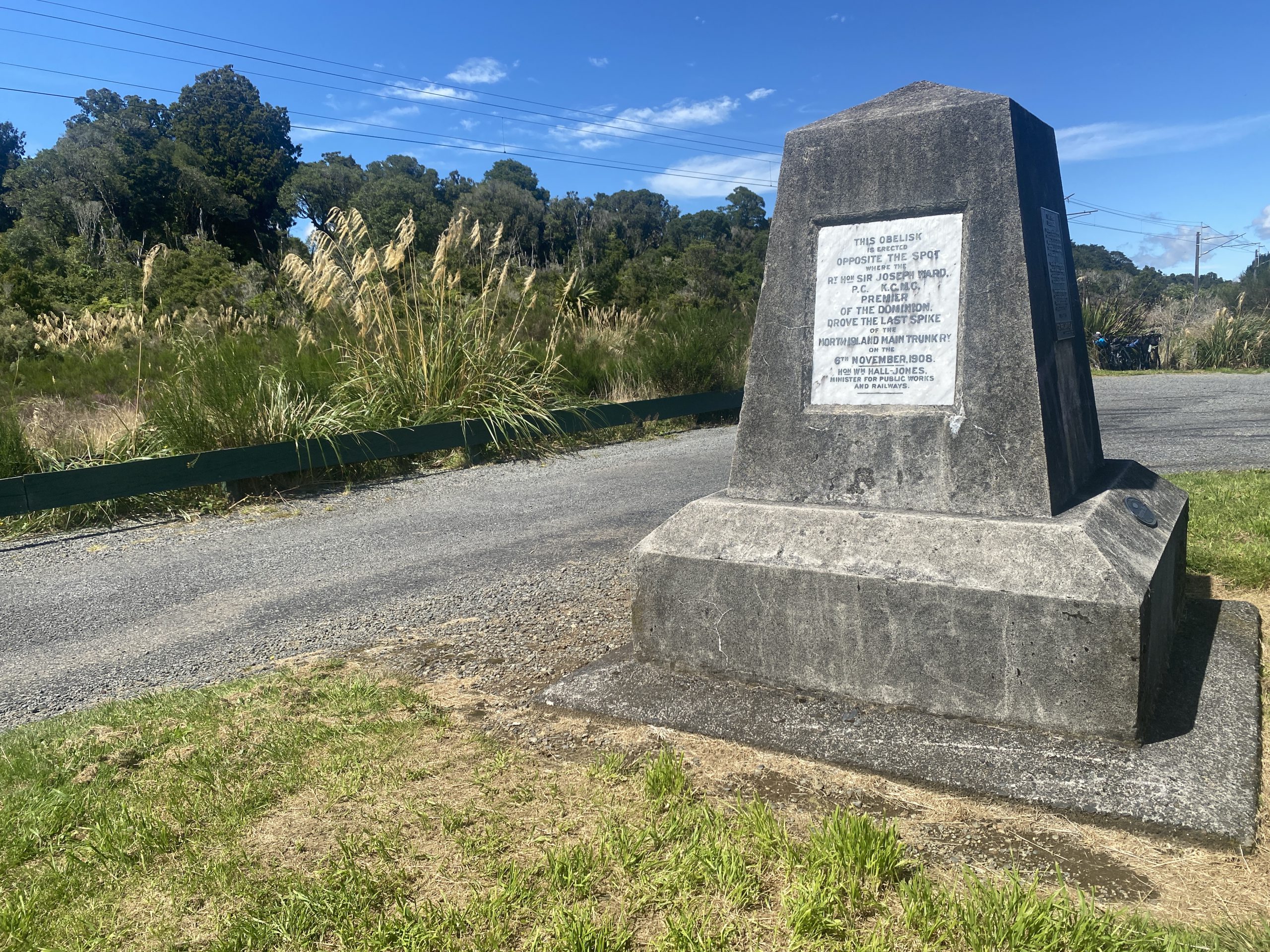
Standard gauge on all New Zealand railroads is 3'6", which over a foot narrower than the North American standard of 4'8.5". This allows for tighter curves and shorter crossties. Much of the North Island line is electrified. By accident we stopped at a rest area where there was a monument to the "golden spike" location.
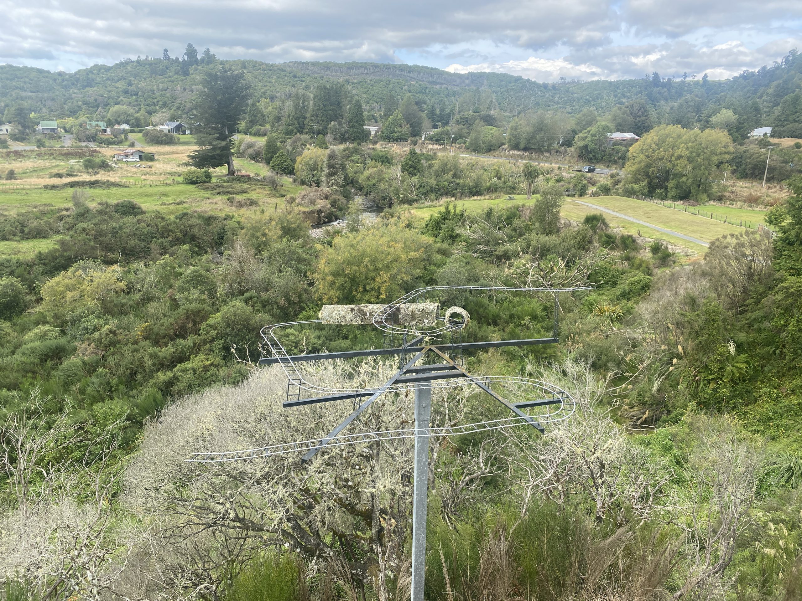
Finally, the video ends with a quick view of the Raurimu Spiral on the North Island near National Park. It's where the main line crosses over itself above a tunnel, then continues on through reversing horseshoe curves. Not much is actually visible due to the geography and plant life, and the road to get to that location is a bit rough at the end. Never did see any rail traffic on the North Island lines, and the place we stayed at Raurimu, while near enough to the railroad at the bottom of the Spiral to hear it, didn't have a view.
Posted on
Kea at Arthur's Pass, South Island, New Zealand
Video by H.Koenig
Nothing thermal here. Just found the behaviors of this mob of at least 18 juvenile kea to be interesting and entertaining.
Behind the building, someone left scraps of what appeared to be potatoes, carrots or kumara, which may be what attracted them. For reasons of their own, they returned to this building the next morning.
Despite the wide open doors and windows, never saw any of them enter the building.
Their habit of prying at the nails in the roofs in this area is a problem, because most of these buildings are a century old, dating back to when the Otira Tunnel (8.5km long) was being built. (It opened in 1923.) Roofing materials, including nail heads, contained lead back then, and some kea have shown signs of lead poisoning.
Posted on
New Zealand 2023 Postings
Videos:
- Sapphire and Cascade Geysers, Orakeikorako
- Wairiri Geyser, Orakeikorako
- Bush Geyser, Orakeikorako
- Artist's Palette, Orakeikorako
- Waimangu Valley
- Steaming Cliffs at Rotomahana, Waimangu
- Waiotapu Mudpots
- Champagne Pool, Waiotapu
- Te Manaroa, Waikite
- Kereru, Whakarewarewa
- Pohutu, Whakarewarewa
- Mahanga, Whakarewarewa
- Whakarewarewa Thermal Walkway
- Whakarewarewa Forest Mudpot
- Hoani, Tokaanu
- Taumatapuhipuhi, Tokaanu
- Puanga & Mangaroa Street Features, Tokaanu
- Te Kopia
- Kuirau Park, Rotorua
- Rotorua Lakeshore and Government Gardens
Observation reports:
- 2023 March 04 : Tokaanu, Karapiti/ Craters of the Moon, Wairakei
- 2023 March 05 : Waiotapu, Waikite, Te Kopia
- 2023 March 06 : Whakarewarewa / Te Puia
- 2023 March 07 : Waimangu & Rotomahana
- 2023 March 08 : Orakeikorako
- 2023 March 09 : Whakarewarewa Village
- 2023 March 10 : Kuirau Park
- 2023 March 11 : Tikitere / Hell's Gate
- 2023 March 12 : Rotorua (Government Gardens, Lakeshore, Puarenga Stream), Whakarewarewa Forest
Other, non-thermal videos:
Posted on
Kuirau Park, New Zealand
Posted on
Puanga & Mangaroa St. Features, Tokaanu, New Zealand
Video by H.Koenig
Posted on
Whakarewarewa Forest Mudpot, Rotorua, New Zealand
Posted on
Te Kopia, New Zealand
Posted on
Sapphire and Cascade Geysers, Orakeikorako, New Zealand
Posted on
Wairiri Geyser, Orakeikorako, New Zealand
Update 2023-July-18: It turns out that the name "Manganese Pool", used in most published sources, appears to be the correct name for this feature, despite what the sign says.
Posted on